Country:
 France
Region:
City:
Latitude and Longitude:
Time Zone:
Postal Code:
IP information under different IP Channel
ip-api
Country
Region
City
ASN
Time Zone
ISP
Blacklist
Proxy
Latitude
Longitude
Postal
Route
IPinfo
Country
Region
City
ASN
Time Zone
ISP
Blacklist
Proxy
Latitude
Longitude
Postal
Route
MaxMind
Country
Region
City
ASN
Time Zone
ISP
Blacklist
Proxy
Latitude
Longitude
Postal
Route
Luminati
Country
FRRegion
idf
City
saintouen
ASN
Time Zone
Europe/Paris
ISP
ADISTA SAS
Latitude
Longitude
Postal
db-ip
Country
Region
City
ASN
Time Zone
ISP
Blacklist
Proxy
Latitude
Longitude
Postal
Route
ipdata
Country
Region
City
ASN
Time Zone
ISP
Blacklist
Proxy
Latitude
Longitude
Postal
Route
Popular places and events near this IP address
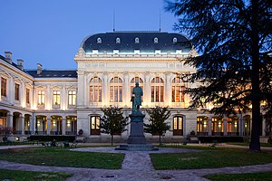
University of Lyon
Cluster of several higher education institutions in the region of Lyon, France
Distance: Approx. 447 meters
Latitude and longitude: 45.748151,4.852352
The University of Lyon (French: Université de Lyon, or UdL) is a community of universities and establishments (ComUE) based in Lyon, France. It comprises 12 members and 9 associated institutions. The three main universities in this center are: Claude Bernard University Lyon 1, which focuses upon health and science studies and has approximately 27,000 students; Lumière University Lyon 2, which focuses upon the social sciences and arts, and has about 30,000 students; Jean Moulin University Lyon 3, which focuses upon the law and humanities with about 20,000 students.
Lyon Anglican Church
Church in France
Distance: Approx. 723 meters
Latitude and longitude: 45.746,4.8379
The Lyon Anglican Church (now known as Trinity Church Lyon) is a church of the Anglican Archdeaconry of France, part of the Diocese of Europe and is run by the Intercontinental Church Society. English-language church services were first held in Lyon by a Rev. McDermott as early as 1843.
Institut d'études politiques de Lyon
Political science school in Lyon, France
Distance: Approx. 852 meters
Latitude and longitude: 45.74694444,4.83580556
The Institut d'Études politiques de Lyon (or Lyon Institute of Political Studies) also known as Sciences Po Lyon, is a grande école located in Lyon, France. It is one of ten Institutes of Political Studies in France, and was established in 1948 by Charles de Gaulle's provisional government following the model of the École Libre des Sciences Politiques. It is located at the Centre Berthelot within the buildings of a former military health college and operates as an autonomous institution within the University of Lyon.

African Museum of Lyon
Museum of African art, ethnographic museum in Lyon, France
Distance: Approx. 896 meters
Latitude and longitude: 45.74986111,4.85791667
The African Museum of Lyon (French: Musée Africain de Lyon) is the oldest museum in France dedicated to Africa and African art, and one of the oldest museums in Lyon. The collections specialise in West African objects. From 2012 to 2017, the museum was managed by a secular association, the Association du Musée Africain de Lyon.

Lumière University Lyon 2
Distance: Approx. 781 meters
Latitude and longitude: 45.75083333,4.83722222
Lumière University Lyon 2 (French: Université Lumière Lyon 2) is one of the three universities that comprise the current University of Lyon, having splintered from an older university of the same name, and is primarily based on two campuses in Lyon itself. It has a total of 27,500 students studying for three-to-eight-year degrees in the arts, humanities and social sciences.

Centre d'histoire de la résistance et de la déportation
Distance: Approx. 852 meters
Latitude and longitude: 45.74694444,4.83580556
The Centre d'histoire de la résistance et de la déportation (English: Center for the History of the Resistance and Deportation) is a museum in Lyon, France.
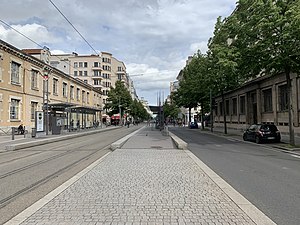
Avenue Berthelot
Street in Lyon, France
Distance: Approx. 715 meters
Latitude and longitude: 45.7425,4.85055556
Avenue Berthelot is a street in the 7th (Guillotière) and 8th arrondissement (Bachut) of Lyon which connects the Galliéni bridge at the east to the A43 highway via the avenue Jean Mermoz which extends it to the west.

Lyon-Jean Macé station
Railway station in the 7th arrondissement of Lyon, France
Distance: Approx. 527 meters
Latitude and longitude: 45.7451,4.8416
Lyon-Jean Macé station (French: Gare de Lyon-Jean Macé) is a railway station in the 7th arrondissement of Lyon. It is situated on the Paris–Marseille railway and the Lyon–Geneva railway. The station is a part of the Lyon urban area rapid transit network.

Rue de l'Université, Lyon
Distance: Approx. 325 meters
Latitude and longitude: 45.74888889,4.8425
The Rue de l'Université is a large street in the 7th arrondissement of Lyon which connects the Pont de l'Université and the Avenue Jean-Jaurès. It is extended to the east by the rue Marc Bloch then the route de Vienne. It was named after the presence of several university buildings, built at the end of the nineteenth century starting in 1884.

Château de La Motte (Lyon)
Distance: Approx. 616 meters
Latitude and longitude: 45.7446,4.8525
Château de La Motte is a French castle that is also known as The castle of La Motte or just La Mothe. It is located in the 7th arrondissement of Lyon, on the left bank of the Rhône. It stands near the junction of two ancient roads of eastern and southern Lyon, on the border between the Dauphiné and Lyonnais.

Berges du Rhône
Distance: Approx. 921 meters
Latitude and longitude: 45.754,4.838
The Berges du Rhône (Banks of the Rhône) or Quais du Rhône (Quays of the Rhône) refer to a series of parks, quays, streets and walking paths along the Rhône river in Lyon, France. The construction for the modern Berges du Rhône took place between 2005 and 2007, resulting in the development of 10 hectares of land on the left and right banks of the Rhône from Parc de la Tête d'Or to Parc de Gerland.
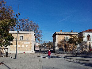
Parc Sergent Blandan
Urban park in Lyon, France
Distance: Approx. 682 meters
Latitude and longitude: 45.745,4.854
Parc Sergent Blandan, also shortened to Parc Blandan, is an urban park in the 7th arrondissement of Lyon in Lyon, France, adjacent to Cimetière de la Guillotière Ancien. With an area of 17 hectares (42 acres), the park opened to the public on 13 September 2013 at the location of Caserne sergent Blandan, a military barracks previously known as "Fort Lamothe". The park has three distinct areas: a multi-purpose square to the north, an ecological area to the south, and a central garden that surrounds the barracks' ramparts.
Weather in this IP's area
clear sky
22 Celsius
22 Celsius
21 Celsius
22 Celsius
1021 hPa
73 %
1021 hPa
1001 hPa
10000 meters
3.09 m/s
340 degree
06:20:31
21:13:25