Country:
 Switzerland
Region:
City:
Latitude and Longitude:
Time Zone:
Postal Code:
IP information under different IP Channel
ip-api
Country
Region
City
ASN
Time Zone
ISP
Blacklist
Proxy
Latitude
Longitude
Postal
Route
IPinfo
Country
Region
City
ASN
Time Zone
ISP
Blacklist
Proxy
Latitude
Longitude
Postal
Route
MaxMind
Country
Region
City
ASN
Time Zone
ISP
Blacklist
Proxy
Latitude
Longitude
Postal
Route
Luminati
Country
CHASN
Time Zone
Europe/Zurich
ISP
NTS workspace AG
Latitude
Longitude
Postal
db-ip
Country
Region
City
ASN
Time Zone
ISP
Blacklist
Proxy
Latitude
Longitude
Postal
Route
ipdata
Country
Region
City
ASN
Time Zone
ISP
Blacklist
Proxy
Latitude
Longitude
Postal
Route
Popular places and events near this IP address

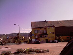
Frauenfeld
Municipality in Switzerland
Distance: Approx. 896 meters
Latitude and longitude: 47.55,8.9
Frauenfeld (Alemannic: Frauefäld) is the capital of the canton of Thurgau in Switzerland. The official language of Frauenfeld is (the Swiss variety of Standard) German, but the main spoken language is the local variant of the Alemannic Swiss German dialect.
Felben-Wellhausen
Municipality in Thurgau, Switzerland
Distance: Approx. 3837 meters
Latitude and longitude: 47.58333333,8.93333333
Felben-Wellhausen is a municipality in the district of Frauenfeld in the canton of Thurgau in Switzerland. The municipality was created in 1983 by a merger of Felben and Wellhausen.
Warth-Weiningen
Municipality in Thurgau, Switzerland
Distance: Approx. 3707 meters
Latitude and longitude: 47.58333333,8.86666667
Warth-Weiningen is a municipality in the district of Frauenfeld in the canton of Thurgau in Switzerland.
Frauenfeld District
District in Switzerland
Distance: Approx. 1458 meters
Latitude and longitude: 47.55,8.88333333
Frauenfeld District is one of the five districts of the canton of Thurgau, Switzerland. It has a population of 69,773 (as of 31 December 2020). Its capital, and the capital of Thurgau, is the city of Frauenfeld.
Felben
Distance: Approx. 3837 meters
Latitude and longitude: 47.58333333,8.93333333
Felben is a village and former municipality in the canton of Thurgau, Switzerland. It was first recorded in the year 1178 as Veluen. In 1433 it was known as Felwan.
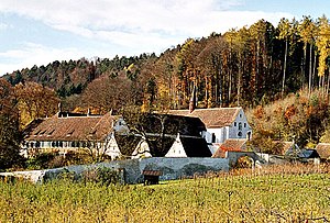
Ittingen Charterhouse
Carthusian monastery near Warth, Thurgau, Switzerland
Distance: Approx. 3721 meters
Latitude and longitude: 47.5838,8.8672
Ittingen Charterhouse (Kartause Ittingen) is a former Carthusian monastery near Warth, Canton Thurgau, Switzerland. It is now used as an education and seminar centre with two museums and a farm.

Frauenfeld Castle
Castle in Switzerland
Distance: Approx. 342 meters
Latitude and longitude: 47.555186,8.896877
Frauenfeld Castle is a castle in the municipality of Frauenfeld of the Canton of Thurgau in Switzerland. It is a Swiss heritage site of national significance.

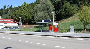
Frauenfeld railway station
Distance: Approx. 132 meters
Latitude and longitude: 47.55805556,8.89694444
Frauenfeld railway station is a railway station in the Swiss canton of Thurgau and municipality of Frauenfeld. The station is located on the Winterthur–Romanshorn railway line, and is the terminus of the narrow-gauge Frauenfeld–Wil railway line. On the main line, Frauenfeld is an intermediate stop on the InterCity service from Brig to Romanshorn, the InterRegio service from Lucerne to Konstanz, and on Zürich S-Bahn services S24 and S30.
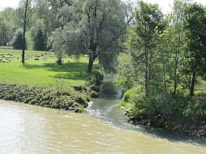
Murg (Thur)
River in Switzerland
Distance: Approx. 2620 meters
Latitude and longitude: 47.5795,8.8845
The Murg is a 34.1 kilometres (21.2 mi) long tributary of the Thur in Switzerland. It rises in the canton of St. Gallen, flows through the canton of Thurgau, and joins the Thur near Warth.

Frauenfeld Marktplatz railway station
Distance: Approx. 458 meters
Latitude and longitude: 47.55388889,8.89888889
Frauenfeld Marktplatz railway station (German: Bahnhof Frauenfeld Marktplatz) is a railway station in the municipality of Frauenfeld, in the Swiss canton of Thurgau. It is located on the 1,000 mm (3 ft 3+3⁄8 in) Frauenfeld–Wil line of Appenzell Railways.

Lüdem railway station
Distance: Approx. 1804 meters
Latitude and longitude: 47.54194444,8.90194444
Lüdem railway station (German: Bahnhof Lüdem) is a railway station in the municipality of Frauenfeld, in the Swiss canton of Thurgau. It is located on the 1,000 mm (3 ft 3+3⁄8 in) Frauenfeld–Wil line of Appenzell Railways, and is served as a request stop by local trains only.
Weberei Matzingen railway station
Distance: Approx. 3873 meters
Latitude and longitude: 47.52694444,8.92194444
Weberei Matzingen railway station (German: Bahnhof Weberei Matzingen) is a railway station in the municipality of Matzingen, in the Swiss canton of Thurgau. It is located on the 1,000 mm (3 ft 3+3⁄8 in) Frauenfeld–Wil line of Appenzell Railways, and is served as a request stop by local trains only.
Weather in this IP's area
clear sky
18 Celsius
18 Celsius
17 Celsius
19 Celsius
1025 hPa
93 %
1025 hPa
976 hPa
10000 meters
1.51 m/s
1.56 m/s
44 degree
2 %
05:58:30
21:03:01