Country:
 Netherlands
Region:
City:
Latitude and Longitude:
Time Zone:
Postal Code:
IP information under different IP Channel
ip-api
Country
Region
City
ASN
Time Zone
ISP
Blacklist
Proxy
Latitude
Longitude
Postal
Route
IPinfo
Country
Region
City
ASN
Time Zone
ISP
Blacklist
Proxy
Latitude
Longitude
Postal
Route
MaxMind
Country
Region
City
ASN
Time Zone
ISP
Blacklist
Proxy
Latitude
Longitude
Postal
Route
Luminati
Country
NLRegion
zh
City
rotterdam
ASN
Time Zone
Europe/Amsterdam
ISP
IP Visie Networking B.V.
Latitude
Longitude
Postal
db-ip
Country
Region
City
ASN
Time Zone
ISP
Blacklist
Proxy
Latitude
Longitude
Postal
Route
ipdata
Country
Region
City
ASN
Time Zone
ISP
Blacklist
Proxy
Latitude
Longitude
Postal
Route
Popular places and events near this IP address
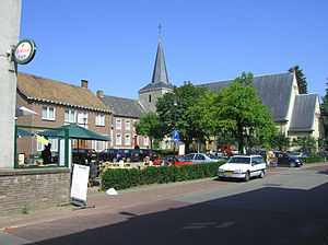
Margraten
Village and former municipality in Limburg, Netherlands
Distance: Approx. 544 meters
Latitude and longitude: 50.81666667,5.81666667
Margraten (Dutch: [mɑrˈɣraːtə(n)] ; Limburgish: Mergraote) is a village and a former municipality in the southeastern part of the Netherlands. On 1 January 2011 this former municipality merged with a neighbouring one, which resulted in the new Eijsden-Margraten municipality.

Banholt
Village in Limburg, Netherlands
Distance: Approx. 3551 meters
Latitude and longitude: 50.78972222,5.80944444
Banholt (Limburgish: Tebannet) is a village in the Dutch province of Limburg. It is part of the municipality of Eijsden-Margraten and lies about 10 km southeast of Maastricht. The village was first mentioned in 1294 or 1295 as Bannoyt.
Cadier en Keer
Village in Limburg, Netherlands
Distance: Approx. 3681 meters
Latitude and longitude: 50.82722222,5.76944444
Cadier en Keer (Limburgish: Keer) is a village in the Dutch province of Limburg. It is a part of the municipality of Eijsden-Margraten, and lies about 5 km east of Maastricht.

Terhorst
Hamlet in Limburg, Netherlands
Distance: Approx. 3765 meters
Latitude and longitude: 50.78711,5.81608
Terhorst (in Limburgs dialect: Terhoorsj) is a little hamlet of 33 houses and part of the village of Banholt (in Limburgs dialect: Tebannet), which is in the municipality of Eijsden-Margraten in the province of Limburg, Netherlands. In the middle of the village, Terhorst has its own little chapel built in 1949 and every year in August there is the traditional annual Chapel party (kapelfeest). Terhorst is not a statistical entity, and the postal authorities have placed it under Banholt.
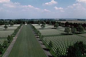
Netherlands American Cemetery
ABMC World War II cemetery in the Netherlands
Distance: Approx. 1533 meters
Latitude and longitude: 50.81666667,5.8
Netherlands American Cemetery and Memorial (Dutch: Amerikaanse Begraafplaats Margraten) is a Second World War military war grave cemetery, located in the village of Margraten, 10 km (6.2 mi) east of Maastricht, in the most southern part of the Netherlands. The cemetery, the only American one in the Netherlands and dedicated in 1960, contains a constantly varying number above 8,000 American war dead and covers 65.5 acres (26.5 ha). It is administered by the American Battle Monuments Commission (ABMC).
Cadier
Village in Limburg, Netherlands
Distance: Approx. 4054 meters
Latitude and longitude: 50.83333333,5.76666667
Cadier is a former village in the Dutch province of Limburg. It is now part of Cadier en Keer. Until 1828, "Cadier" was also the name of a municipality; it then changed its name to "Cadier en Keer".
Vilt
Village in Limburg, Netherlands
Distance: Approx. 4118 meters
Latitude and longitude: 50.85722222,5.81055556
Vilt is a village in the Dutch province of Limburg, within the municipality of Valkenburg aan de Geul. It is located on the top of the Cauberg. The village was first mentioned in the 14th century as Velt, and means field.

Reijmerstok
Village in Limburg, Netherlands
Distance: Approx. 2646 meters
Latitude and longitude: 50.79916667,5.83638889
Reijmerstok (Limburgish: Rimmesjtók) is a village in the municipality Gulpen-Wittem in the Dutch province of Limburg. It lies southwest of Gulpen and counts about 600 inhabitants. In the village several half timbered houses can be found.

1938 UCI Road World Championships
Cycling championship held in Valkenburg, Netherlands
Distance: Approx. 3333 meters
Latitude and longitude: 50.84972222,5.83305556
The 1938 UCI Road World Championships was the eighteenth edition of the UCI Road World Championships. It took place in Valkenburg, the Netherlands on 2 and 5 September 1938. Belgian Marcel Kint became the winner in the professional road race.

1948 UCI Road World Championships
Cycling championship held in Valkenburg, Netherlands
Distance: Approx. 3333 meters
Latitude and longitude: 50.84972222,5.83305556
The 1948 UCI Road World Championships was the 21st edition of the UCI Road World Championships It took place on Saturday 21 and Sunday 22 August 1948 in Valkenburg, the Netherlands. For the first time, six riders per country were allowed to participate in the professional race. The Cauberg had to be climbed every lap.

Honthem
Hamlet in Limburg, Netherlands
Distance: Approx. 1384 meters
Latitude and longitude: 50.81388889,5.80444444
Honthem is a hamlet in the Limburg province of the Netherlands, about 7 km from Maastricht. It was the first mentioned in 1375 as Huynthem, and means "settlement of Hundo (person)". Honthem has placed name signs.

Sibbe
Village in Limburg, Netherlands
Distance: Approx. 2531 meters
Latitude and longitude: 50.84333333,5.82555556
Sibbe (Limburgish: Sub or Süp) is the official Dutch name of a village in the municipality of Valkenburg aan de Geul in the province of Limburg in the southern part of the Netherlands.
Weather in this IP's area
broken clouds
16 Celsius
16 Celsius
14 Celsius
17 Celsius
1018 hPa
84 %
1018 hPa
998 hPa
10000 meters
2.06 m/s
150 degree
55 %
06:00:32
21:25:34