Country:
 Greece
Region:
City:
Latitude and Longitude:
Time Zone:
Postal Code:
IP information under different IP Channel
ip-api
Country
Region
City
ASN
Time Zone
ISP
Blacklist
Proxy
Latitude
Longitude
Postal
Route
IPinfo
Country
Region
City
ASN
Time Zone
ISP
Blacklist
Proxy
Latitude
Longitude
Postal
Route
MaxMind
Country
Region
City
ASN
Time Zone
ISP
Blacklist
Proxy
Latitude
Longitude
Postal
Route
Luminati
Country
GRASN
Time Zone
Europe/Athens
ISP
Th.papamichail Vainas - G.psaltakis G.p
Latitude
Longitude
Postal
db-ip
Country
Region
City
ASN
Time Zone
ISP
Blacklist
Proxy
Latitude
Longitude
Postal
Route
ipdata
Country
Region
City
ASN
Time Zone
ISP
Blacklist
Proxy
Latitude
Longitude
Postal
Route
Popular places and events near this IP address

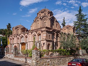
Hagios Demetrios
Main sanctuary dedicated to Saint Demetrius
Distance: Approx. 363 meters
Latitude and longitude: 40.63888889,22.94777778
The Church of Saint Demetrius, or Hagios Demetrios (Greek: Άγιος Δημήτριος), is the main sanctuary dedicated to Saint Demetrius, the patron saint of Thessaloniki (in Central Macedonia, Greece), dating from a time when it was the second largest city of the Byzantine Empire. Since 1988, it has been on the UNESCO World Heritage List as a part of the site Paleochristian and Byzantine monuments of Thessaloniki.

Karipeion Melathron
Distance: Approx. 273 meters
Latitude and longitude: 40.6421,22.9461
Karipeio Melathro (Greek: Καρίπειο Μέλαθρο) is an Ottoman-period historical building in the center of Thessaloniki, Greece. It is located in the crossroad of Olympiados and Stefaniou Dragoumi streets. Its architect is the Italian Vitaliano Poselli.

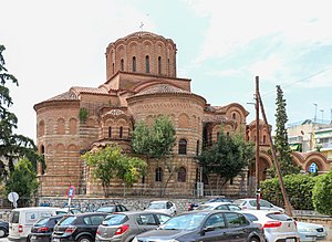
Church of Panagia Chalkeon
11th-century Byzantine church and UNESCO World Heritage site in Thessaloniki, Greece
Distance: Approx. 390 meters
Latitude and longitude: 40.63680556,22.94361111
The Church of Panagia Chalkeon (Greek: Παναγία τῶν Χαλκέων) is an 11th-century Byzantine church in the northern Greek city of Thessaloniki. The church's well-preserved Byzantine architecture and testimony to the importance of Thessaloniki in early and medieval Christianity led it to be inscribed on the UNESCO World Heritage List in 1988 along with other Paleochristian and Byzantine monuments of Thessaloniki.
Siege of Thessalonica (1422–1430)
Ottoman capture of the Byzantine city
Distance: Approx. 325 meters
Latitude and longitude: 40.6375,22.945
The siege of Thessalonica between 1422 and 1430 saw the Ottoman Empire, under Sultan Murad II, capture the city of Thessalonica. Afterwards, the city remained in Ottoman hands for the next five centuries until it became part of the Kingdom of Greece in 1912. Thessalonica had already been under Ottoman control from 1387 to 1403 before returning to Byzantine rule in the aftermath of the Battle of Ankara.

Battle of Thessalonica (380)
Distance: Approx. 0 meters
Latitude and longitude: 40.6403,22.9439
The Battle of Thessalonica was fought in the summer or autumn of 380 by Fritigern's Goths and a Roman army led by Theodosius I. Reconstituted after Adrianople, the East Roman army suffered another major defeat. Theodosius retreated to Thessalonica and surrendered control of operations to the Western Emperor, Gratian.

Monastir Synagogue (Thessaloniki)
Former Orthodox synagogue in Thessaloniki, Greece
Distance: Approx. 182 meters
Latitude and longitude: 40.6397,22.9419
The Monastir Synagogue (Hebrew: קהל קדוש מונאסטירליס, Judaeo-Spanish "Kal de los Monastirlis") is a former Orthodox Jewish congregation and synagogue of the once vibrant Jewish community in Thessaloniki, Greece.
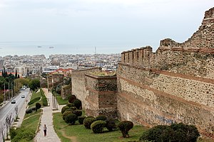
Thessaloniki Province
Distance: Approx. 50 meters
Latitude and longitude: 40.64053,22.944403
Thessaloniki Province was one of the two provinces of Thessaloniki Prefecture of Greece. Its territory corresponded with that of the current municipalities Ampelokipoi-Menemeni, Chalkidona, Delta, Kalamaria, Kordelio-Evosmos, Neapoli-Sykies, Oraiokastro, Pavlos Melas, Pylaia-Chortiatis, Thermaikos, Thermi and Thessaloniki. It was abolished in 2006.
Church of Prophet Elijah (Thessaloniki)
UNESCO World Heritage Site in Macedonia, Greece
Distance: Approx. 379 meters
Latitude and longitude: 40.64083333,22.94833333
The Church of Prophet Elijah (Greek: Ναός Προφήτη Ηλία, Naós Profíti Ilía) is a 14th-century church in Thessaloniki, Greece, and a UNESCO World Heritage Site. The church is located in the upper quarter of the old city, and dates to the Palaiologan period, but its original dedication is unknown. In Ottoman times, it was known as the Saraylı Mosque (Palace Mosque or Court Mosque), and through a misinterpretation of this name came about its modern dedication to the Prophet Elijah.
Church of Saint Catherine, Thessaloniki
UNESCO World Heritage Site in Macedonia, Greece
Distance: Approx. 324 meters
Latitude and longitude: 40.64319444,22.94430556
The Church of Saint Catherine (Greek: Αγία Αικατερίνη) is a late Byzantine church in the northwestern corner of the Ano Poli, Thessaloniki, Greece.

Hamza Bey Mosque
Historical mosque in Thessaloniki, Greece
Distance: Approx. 363 meters
Latitude and longitude: 40.6375,22.9417
Hamza Bey Mosque (Greek: Αλκαζάρ Θεσσαλονίκης, Turkish: Hamza Bey Camii) is a 15th-century Ottoman Mosque in Thessaloniki, Greece. Modern Thessalonians commonly known it as Alkazar, after a cinema that operated in the premises for decades.

Government House (Thessaloniki)
Distance: Approx. 98 meters
Latitude and longitude: 40.640848,22.9448068
The Konak (Turkish: Konak, Greek: Κονάκι; also known as the Government House (Διοικητήριο)) is an Ottoman-era building in central Thessaloniki, Greece. Originally built in 1891 as the residence (konak) of the governor-general (vali) of the Salonica Vilayet and the seat of the Ottoman authorities, it now houses the Ministry of Macedonia and Thrace.

Roman Forum (Thessaloniki)
Distance: Approx. 311 meters
Latitude and longitude: 40.638,22.946
The Roman Forum of Thessaloniki is the ancient Roman-era forum of the city, located at the upper side of Aristotelous Square. It is a large two-terraced forum featuring two-storey stoas, dug up by accident in the 1960s. The forum complex also boasts two Roman baths, one of which has been excavated while the other is buried underneath the city, and a small theater which was also used for gladiatorial games.
Weather in this IP's area
few clouds
34 Celsius
34 Celsius
33 Celsius
36 Celsius
1014 hPa
30 %
1014 hPa
1008 hPa
10000 meters
4.63 m/s
270 degree
20 %
06:20:28
20:48:45