Country:
 Germany
Region:
City:
Latitude and Longitude:
Time Zone:
Postal Code:
IP information under different IP Channel
ip-api
Country
Region
City
ASN
Time Zone
ISP
Blacklist
Proxy
Latitude
Longitude
Postal
Route
IPinfo
Country
Region
City
ASN
Time Zone
ISP
Blacklist
Proxy
Latitude
Longitude
Postal
Route
MaxMind
Country
Region
City
ASN
Time Zone
ISP
Blacklist
Proxy
Latitude
Longitude
Postal
Route
Luminati
Country
DERegion
nw
City
wuppertal
ASN
Time Zone
Europe/Berlin
ISP
PHILUNET GmbH
Latitude
Longitude
Postal
db-ip
Country
Region
City
ASN
Time Zone
ISP
Blacklist
Proxy
Latitude
Longitude
Postal
Route
ipdata
Country
Region
City
ASN
Time Zone
ISP
Blacklist
Proxy
Latitude
Longitude
Postal
Route
Popular places and events near this IP address

Düsseldorf-Benrath
Quarter of Düsseldorf in North Rhine-Westphalia, Germany
Distance: Approx. 2235 meters
Latitude and longitude: 51.16138889,6.87388889
Benrath (German pronunciation: [ˈbɛnʁaːt]) is a quarter of Düsseldorf in the south of the city, part of Borough 9. It has been a part of Düsseldorf since 1929. Benrath has an area of 5.99 km2 (2.31 sq mi), and 17,178 inhabitants (2020).
Schloss Benrath
Castle in Düsseldorf, Germany
Distance: Approx. 2278 meters
Latitude and longitude: 51.16083333,6.87
Schloss Benrath (Benrath Palace) is a Baroque-style maison de plaisance (pleasure palace) in Benrath, which is now a borough of Düsseldorf. It was erected for the Elector Palatine Charles Theodor and his wife, Countess Palatine Elisabeth Auguste of Sulzbach, by his garden and building director Nicolas de Pigage. Construction began in 1755 and was completed in 1770.
Düsseldorf-Eller
City district of Düsseldorf, Germany
Distance: Approx. 2861 meters
Latitude and longitude: 51.2,6.84166667
Eller is an urban quarter of Düsseldorf, part of Borough 8. It is located southeast of the city centre. Eller has been a part of Düsseldorf since the year 1909.

Hassels
City district of Düsseldorf, Germany
Distance: Approx. 371 meters
Latitude and longitude: 51.17916667,6.87388889
Hassels is an urban quarter in Düsseldorf, Germany, part of Borough 9. It has an area of 4.37 km2 (1.69 sq mi), and 18,465 inhabitants (2020). It was called "Hasselholt" (modern German Haselholz) meaning hazel wood until the 17th century, when it was shortened to its current name.

Düsseldorf-Holthausen
Stadtteil of Düsseldorf in North Rhine-Westphalia, Germany
Distance: Approx. 2858 meters
Latitude and longitude: 51.17194444,6.83166667
Holthausen is an urban quarter of Düsseldorf, part of Borough 9. It is located south of Oberbilk, west of Reisholz, north of Benrath and east of Itter and Himmelgeist. A natural border is the river Rhine.

Reisholz
City district of Düsseldorf, Germany
Distance: Approx. 613 meters
Latitude and longitude: 51.17638889,6.86583333
Reisholz is an urban quarter of Düsseldorf, part of Borough 9. It is located in the south of the city, bordering Holthausen, Benrath, Hassels and the river Rhine. It has an area of 1.85 km2 (0.71 sq mi), and 3,753 inhabitants (2020).

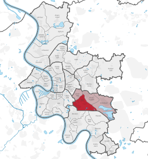
Borough 9 (Düsseldorf)
Borough of Düsseldorf in North Rhine-Westphalia, Germany
Distance: Approx. 926 meters
Latitude and longitude: 51.17777778,6.85777778
Borough 9 (German: Stadtbezirk 9) is a southern borough of Düsseldorf, the state capital of North Rhine-Westphalia, Germany. The borough covers an area of 36.57 square kilometres and (as of December 2020) has approximately 94,000 inhabitants, making it the city's second most populous borough after Borough 3. The borough borders Düsseldorf Boroughs 3 and 8 to the north, and 10 to the south.

Düsseldorf-Benrath station
Distance: Approx. 2204 meters
Latitude and longitude: 51.16225,6.87838889
Düsseldorf-Benrath station is about 10 kilometres south of Düsseldorf Hauptbahnhof in the Düsseldorf district of Benrath. It is on the Cologne–Duisburg line, and is classified by Deutsche Bahn as a category 3 station. In addition, Düsseldorf Benrath station is served by two Regional-Express services, several city bus services and two Stadtbahn lines.

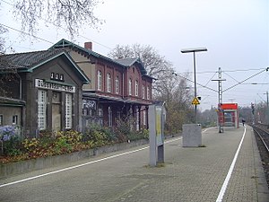
Düsseldorf-Reisholz station
Distance: Approx. 609 meters
Latitude and longitude: 51.18075,6.86111111
Düsseldorf-Reisholz is a railway station situated at Reisholz, Düsseldorf in western Germany. It is served by Rhine-Ruhr S-Bahn line S 6 at 20-minute intervals and several services on line S68 during the peak.

Düsseldorf-Eller Süd station
Distance: Approx. 2979 meters
Latitude and longitude: 51.19791667,6.83633333
Düsseldorf-Eller Süd station is located approximately 5 kilometres south of Düsseldorf Hauptbahnhof in the district of Eller in the city of Düsseldorf in the German state of North Rhine-Westphalia. It is on the Cologne–Duisburg line and is classified by Deutsche Bahn as a category 5 station. It is served by Rhine-Ruhr S-Bahn lines S 6 every 20 minutes and by a few services of S 68 in the peak hour.
Düsseldorf-Eller station
Distance: Approx. 2631 meters
Latitude and longitude: 51.202294,6.852475
Düsseldorf-Eller station is located in the district of Eller in the German city of Düsseldorf in the German state of North Rhine-Westphalia. It is on the Düsseldorf–Solingen line and is classified by Deutsche Bahn as a category 5 station.
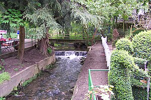
Itter (Rhine)
River of North Rhine-Westphalia, Germany
Distance: Approx. 2997 meters
Latitude and longitude: 51.1551,6.8599
Itter is a river of North Rhine-Westphalia, Germany. It is a right tributary of the Rhine in Benrath.
Weather in this IP's area
clear sky
28 Celsius
27 Celsius
26 Celsius
29 Celsius
1021 hPa
39 %
1021 hPa
1016 hPa
10000 meters
2.57 m/s
05:53:28
21:24:17