Country:
 Romania
Region:
City:
Latitude and Longitude:
Time Zone:
Postal Code:
IP information under different IP Channel
ip-api
Country
Region
City
ASN
Time Zone
ISP
Blacklist
Proxy
Latitude
Longitude
Postal
Route
IPinfo
Country
Region
City
ASN
Time Zone
ISP
Blacklist
Proxy
Latitude
Longitude
Postal
Route
MaxMind
Country
Region
City
ASN
Time Zone
ISP
Blacklist
Proxy
Latitude
Longitude
Postal
Route
Luminati
Country
ROASN
Time Zone
Europe/Bucharest
ISP
ROMARG SRL
Latitude
Longitude
Postal
db-ip
Country
Region
City
ASN
Time Zone
ISP
Blacklist
Proxy
Latitude
Longitude
Postal
Route
ipdata
Country
Region
City
ASN
Time Zone
ISP
Blacklist
Proxy
Latitude
Longitude
Postal
Route
Popular places and events near this IP address
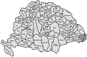
Háromszék County
County of the Kingdom of Hungary
Distance: Approx. 5 meters
Latitude and longitude: 45.86666667,25.78333333
Háromszék (Three Seats; Romanian: Trei Scaune) was an administrative county (comitatus) of the Kingdom of Hungary. Situated in south-eastern Transylvania, its territory is now in central Romania (in the counties of Covasna, Brașov and Bacău). The capital of the county was Sepsiszentgyörgy (now Sfântu Gheorghe).

Sfântu Gheorghe
Municipality in Covasna, Romania
Distance: Approx. 474 meters
Latitude and longitude: 45.86361111,25.7875
Sfântu Gheorghe (pronounced [ˈsfɨntu ˈɡe̯orɡe] ; Hungarian: Sepsiszentgyörgy or Szentgyörgy [ˈʃɛpʃisɛɲɟørɟ] ; Yiddish: סנט דזשארדזש; English lit.: Saint George) is a city that serves as the seat of Covasna County in Transylvania, Romania. Located in the central part of the country, it lies on the Olt River in a valley between the Baraolt Mountains and the Bodoc Mountains. The town administers two villages, Chilieni (Kilyén) and Coșeni (Szotyor).
Arcuș
Commune in Covasna, Romania
Distance: Approx. 3925 meters
Latitude and longitude: 45.9,25.76666667
Arcuș (Hungarian: Árkos [ˈaːrkoʃ]) is a commune in Covasna County, Transylvania, Romania. Composed of a single village, Arcuș, it became an independent commune when it split from Valea Crișului in 2004. Arcuș previously formed part of the Székely Land region of the historical Transylvania province.

Valea Crișului
Commune in Covasna, Romania
Distance: Approx. 5710 meters
Latitude and longitude: 45.91666667,25.76666667
Valea Crișului (Hungarian: Sepsikőröspatak [ˈʃɛpʃikørøʃpɒtɒk]) is a commune in Covasna County, Transylvania, Romania composed of two villages: Calnic (Kálnok) and Valea Crișului. In 2004, the village of Arcuș split away from Valea Crișului to form an independent commune.
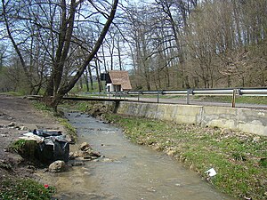
Arcuș (river)
River in Covasna County, Romania
Distance: Approx. 2799 meters
Latitude and longitude: 45.881,25.813
The Arcuș (Hungarian: Árkos-patak) is a right tributary of the river Olt in Romania. It discharges into the Olt near the city Sfântu Gheorghe. Its length is 14 km (8.7 mi) and its basin size is 29 km2 (11 sq mi).
Valea Crișului (river)
River in Covasna County, Romania
Distance: Approx. 5694 meters
Latitude and longitude: 45.9027,25.8355
The Valea Crișului is a right tributary of the river Olt in Romania. It flows into the Olt in Ghidfalău. Its length is 16 km (9.9 mi) and its basin size is 33 km2 (13 sq mi).
Debren (river)
River in Covasna County, Romania
Distance: Approx. 1543 meters
Latitude and longitude: 45.8664,25.8032
The Debren is a right tributary of the river Olt in Romania. It flows into the Olt in the city Sfântu Gheorghe. Its length is 10 km (6.2 mi) and its basin size is 18 km2 (6.9 sq mi).
Sfântu Gheorghe Solar Park
Photovoltaic power stations in Romania
Distance: Approx. 1859 meters
Latitude and longitude: 45.85,25.78333333
Sfântu Gheorghe Solar Park is a large thin-film photovoltaic (PV) power system on a 4 ha plot of land near the Sfântu Gheorghe city in Romania. The power plant is a 2.4-megawatt solar power system using state-of-the-art thin film technology, and was finished by the end of 2012. The solar park is expected to supply 1,000 MWh of electricity per year.

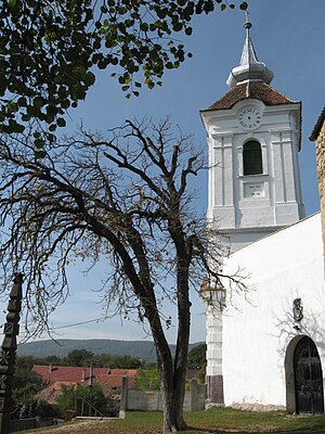
Reformed Church, Ghidfalău
Distance: Approx. 5893 meters
Latitude and longitude: 45.9019,25.8401
The Reformed church of Ghidfalău is a church on the edge of the village, on the hills surrounding the floodplain of the Olt River. It is a stronghold from the Middle Ages, which had an important role in the defence of the local citizens. It is one of those fortresses in Háromszék County which have been built by the residents of multiple municipalities.
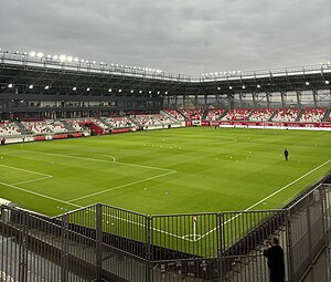
Sepsi Arena Stadium
Romanian stadium
Distance: Approx. 2591 meters
Latitude and longitude: 45.88361111,25.80627778
The Sepsi Arena stadium (Romanian: Stadionul Arena Sepsi, Hungarian: Sepsi Aréna Stadion) is a football stadium in Sfântu Gheorghe, Romania. It was opened in October 2021 and primarily serves as the new home stadium of Sepsi OSK Sfântu Gheorghe. Sepsi played its home matches on Municipal Stadium until the new stadium opened.

St. George's Church, Sfântu Gheorghe
Heritage site in Covasna County, Romania
Distance: Approx. 328 meters
Latitude and longitude: 45.86955,25.78222
St. George's Church (Romanian: Biserica Sfântul Gheorghe) is a Romanian Orthodox church located at 1 Piața Andrei Șaguna, Sfântu Gheorghe, Romania. It is dedicated to Saint George.
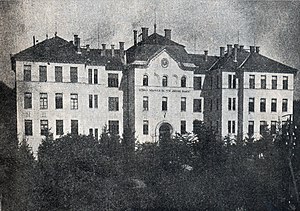
Mihai Viteazul National College (Sfântu Gheorghe)
Romanian high school
Distance: Approx. 660 meters
Latitude and longitude: 45.8608,25.7841
Mihai Viteazul National College (Romanian: Colegiul Național Mihai Viteazul) is a high school located at 22 Kós Károly Street, Sfântu Gheorghe, Romania. The old wing of the school was built in 1908–1910, on the site of a demolished beer factory; the area was then part of Austria-Hungary. New buildings were added over the years, such as a dormitory and a gymnasium.
Weather in this IP's area
few clouds
26 Celsius
26 Celsius
25 Celsius
27 Celsius
1017 hPa
48 %
1017 hPa
955 hPa
10000 meters
2.38 m/s
3.99 m/s
274 degree
15 %
05:56:20
20:50:07