Country:
 Denmark
Region:
City:
Latitude and Longitude:
Time Zone:
Postal Code:
IP information under different IP Channel
ip-api
Country
Region
City
ASN
Time Zone
ISP
Blacklist
Proxy
Latitude
Longitude
Postal
Route
IPinfo
Country
Region
City
ASN
Time Zone
ISP
Blacklist
Proxy
Latitude
Longitude
Postal
Route
MaxMind
Country
Region
City
ASN
Time Zone
ISP
Blacklist
Proxy
Latitude
Longitude
Postal
Route
Luminati
Country
DKRegion
83
City
tonder
ASN
Time Zone
Europe/Copenhagen
ISP
WNB A/S
Latitude
Longitude
Postal
db-ip
Country
Region
City
ASN
Time Zone
ISP
Blacklist
Proxy
Latitude
Longitude
Postal
Route
ipdata
Country
Region
City
ASN
Time Zone
ISP
Blacklist
Proxy
Latitude
Longitude
Postal
Route
Popular places and events near this IP address
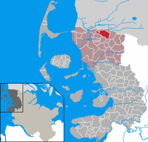
Tønder Municipality
Municipality in Southern Denmark
Distance: Approx. 2130 meters
Latitude and longitude: 54.93333333,8.9
Tønder Municipality (Danish: Tønder Kommune, German: Kommune Tondern, North Frisian: Tuner Komuun) is a kommune in the Region of Southern Denmark on the Jutland peninsula in south Denmark. The municipality covers an area of 1,252 km2, and has a total population of 36,651 (2024). Its mayor is Jørgen Popp Petersen, a member of the regional Schleswig Party.
Süderlügum
Municipality in Schleswig-Holstein, Germany
Distance: Approx. 8057 meters
Latitude and longitude: 54.86666667,8.91666667
Süderlügum (Danish: Sønder Løgum; Mooring North Frisian: Läigem or Sööderläigem; Wiedingharde North Frisian: Leegem) is a municipality in the district of Nordfriesland, in Schleswig-Holstein, Germany. It is situated near the border with Denmark, approximately 35 km west of Flensburg, and 7 km southeast of Tønder. Süderlügum is part of the amt (collective municipality) of Südtondern.
Vidå
Distance: Approx. 2130 meters
Latitude and longitude: 54.93333333,8.9
The Vidå (German: Wiedau, North Frisian Widuu) is a creek in the Jutland region of Denmark.

Tondern raid
Distance: Approx. 1068 meters
Latitude and longitude: 54.93333333,8.85
The Tondern raid or Operation F.7, was a British bombing raid by the Royal Navy and Royal Air Force against the Imperial German Navy airship base at Tønder, Denmark, then a part of Germany. The airships were used for the strategic bombing of Britain. It was the first attack in history by aircraft from an aircraft carrier.

Aventoft
Municipality in Schleswig-Holstein, Germany
Distance: Approx. 6399 meters
Latitude and longitude: 54.88333333,8.81666667
Aventoft (in German and Danish; Oowentoft in North Frisian) is a municipality in the district of Nordfriesland, in Schleswig-Holstein, Germany.

Ellhöft
Municipality in Schleswig-Holstein, Germany
Distance: Approx. 8537 meters
Latitude and longitude: 54.86666667,8.93333333
Ellhöft (Danish: Ellehoved) is a municipality in the district of Nordfriesland, in Schleswig-Holstein, Germany.

Humptrup
Municipality in Schleswig-Holstein, Germany
Distance: Approx. 7395 meters
Latitude and longitude: 54.86666667,8.86666667
Humptrup (Danish: Humtrup) is a municipality in the district of Nordfriesland, in Schleswig-Holstein, Germany.

Uphusum
Municipality in Schleswig-Holstein, Germany
Distance: Approx. 9494 meters
Latitude and longitude: 54.85,8.83333333
Uphusum (Danish: Ophusum) is a municipality in the district of Nordfriesland, in Schleswig-Holstein, Germany.

Süderlügum (Amt)
Former Amt in Germany
Distance: Approx. 8032 meters
Latitude and longitude: 54.867,8.917
Süderlügum was an Amt ("collective municipality") in the district of Nordfriesland, in Schleswig-Holstein, Germany. Its seat was in Süderlügum. In January 2008, it was merged with the Ämter Karrharde, Bökingharde and Wiedingharde, and the municipalities Niebüll and Leck to form the Amt Südtondern.

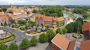
Tønder
Town in Southern Denmark, Denmark
Distance: Approx. 1092 meters
Latitude and longitude: 54.94277778,8.86388889
Tønder (Danish pronunciation: [ˈtsʰønˀɐ]; German: Tondern [ˈtɔndɐn]) is a town in the Region of Southern Denmark. With a population of 7,564 (as of 1 January 2024), it is the main town and the administrative seat of the Tønder Municipality.
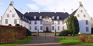
Schackenborg Castle
Distance: Approx. 3854 meters
Latitude and longitude: 54.94272222,8.80880278
Schackenborg Castle (Danish: Schackenborg Slot, pronounced [ˈɕɑkŋ̍ˌpɒˀ ˈslʌt]) is a château located in Møgeltønder Parish, Southern Jutland. From 1993 until 2014, it was the private residence of Prince Joachim of Denmark, the second son of Queen Margrethe II of Denmark.

Nolde Stiftung Seebüll
Museum in Seebüll, Schleswig-Holstein
Distance: Approx. 8081 meters
Latitude and longitude: 54.88405556,8.77361111
The Nolde Stiftung Seebüll, also known as Stiftung Seebüll Ada und Emil Nolde, in English, the Nolde Foundation Seebüll, or the Seebüll Ada and Emil Nolde Foundation, is a foundation established in 1956, who is the sponsor of an art museum in Seebüll, in Schleswig-Holstein, dedicated to the life and works of the German painter Emil Nolde. The museum was opened in 1957, after Nolde's death, by the Seebüll Ada and Emil Nolde Foundation.
Weather in this IP's area
scattered clouds
12 Celsius
11 Celsius
11 Celsius
14 Celsius
1018 hPa
94 %
1018 hPa
1018 hPa
10000 meters
3.37 m/s
6.46 m/s
319 degree
38 %
05:27:10
21:34:39