Country:
 Slovenia
Region:
City:
Latitude and Longitude:
Time Zone:
Postal Code:
IP information under different IP Channel
ip-api
Country
Region
City
ASN
Time Zone
ISP
Blacklist
Proxy
Latitude
Longitude
Postal
Route
IPinfo
Country
Region
City
ASN
Time Zone
ISP
Blacklist
Proxy
Latitude
Longitude
Postal
Route
MaxMind
Country
Region
City
ASN
Time Zone
ISP
Blacklist
Proxy
Latitude
Longitude
Postal
Route
Luminati
Country
SIASN
Time Zone
Europe/Ljubljana
ISP
SEEWEB s.r.l.
Latitude
Longitude
Postal
db-ip
Country
Region
City
ASN
Time Zone
ISP
Blacklist
Proxy
Latitude
Longitude
Postal
Route
ipdata
Country
Region
City
ASN
Time Zone
ISP
Blacklist
Proxy
Latitude
Longitude
Postal
Route
Popular places and events near this IP address

Tržič
Town in Upper Carniola, Slovenia
Distance: Approx. 1481 meters
Latitude and longitude: 46.35808056,14.29295556
Tržič (pronounced [təɾˈʒitʃ] ; German: Neumarktl) is a town in northern Slovenia, close to the Austrian border. It is the seat of the Municipality of Tržič.

Bistrica pri Tržiču
Place in Upper Carniola, Slovenia
Distance: Approx. 1481 meters
Latitude and longitude: 46.35808056,14.29295556
Bistrica pri Tržiču (pronounced [ˈbiːstɾitsa pɾi təɾˈʒiːtʃu]; German: Feistritz) is a settlement in the Municipality of Tržič in the Upper Carniola region of Slovenia.
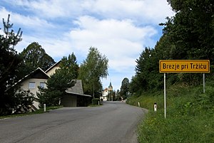
Brezje pri Tržiču
Place in Upper Carniola, Slovenia
Distance: Approx. 2647 meters
Latitude and longitude: 46.35896944,14.2767
Brezje pri Tržiču (pronounced [ˈbɾeːzjɛ pɾi təɾˈʒiːtʃu]) is a settlement in the Municipality of Tržič in the Upper Carniola region of Slovenia. It is located near the road from Tržič to Begunje. In 2018 it had a population of 359.
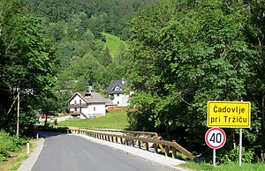
Čadovlje pri Tržiču
Place in Upper Carniola, Slovenia
Distance: Approx. 1906 meters
Latitude and longitude: 46.3786,14.322475
Čadovlje pri Tržiču (pronounced [ˈtʃaːdɔu̯ljɛ pɾi təɾˈʒiːtʃu]) is a settlement in the Municipality of Tržič in the Upper Carniola region of Slovenia.
Križe, Tržič
Place in Upper Carniola, Slovenia
Distance: Approx. 2575 meters
Latitude and longitude: 46.34122222,14.30200833
Križe (pronounced [ˈkɾiːʒɛ]; German: Heiligenkreuz) is a village in the Municipality of Tržič in the Upper Carniola region of Slovenia.
Loka, Tržič
Place in Upper Carniola, Slovenia
Distance: Approx. 2501 meters
Latitude and longitude: 46.34645278,14.28946944
Loka (pronounced [ˈloːka]) is a village in the Municipality of Tržič in the Upper Carniola region of Slovenia.
Lom pod Storžičem
Place in Upper Carniola, Slovenia
Distance: Approx. 1912 meters
Latitude and longitude: 46.36678889,14.33495556
Lom (pronounced [ˈlɔm pɔt ˈstɔːɾʒitʃɛm]) is a village in the Municipality of Tržič in the Upper Carniola region of Slovenia. The local church in this village is dedicated to Saint Catherine.
Potarje, Tržič
Place in Upper Carniola, Slovenia
Distance: Approx. 2179 meters
Latitude and longitude: 46.37228333,14.33592778
Potarje (pronounced [ˈpoːtarjɛ]) is a settlement in the Municipality of Tržič in the Upper Carniola region of Slovenia.
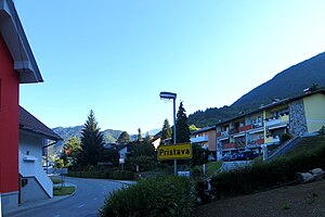
Pristava, Tržič
Place in Upper Carniola, Slovenia
Distance: Approx. 2031 meters
Latitude and longitude: 46.34820278,14.29633056
Pristava (pronounced [pɾiˈstaːʋa]) is a settlement in the Municipality of Tržič in the Upper Carniola region of Slovenia.
Ročevnica
Place in Upper Carniola, Slovenia
Distance: Approx. 2048 meters
Latitude and longitude: 46.35489444,14.28701944
Ročevnica (pronounced [ɾɔˈtʃeːu̯nitsa]) is a settlement in the Municipality of Tržič in the Upper Carniola region of Slovenia.

Slap, Tržič
Place in Upper Carniola, Slovenia
Distance: Approx. 838 meters
Latitude and longitude: 46.36867222,14.31855556
Slap (pronounced [ˈslaːp]) is a settlement in the Municipality of Tržič in the Upper Carniola region of Slovenia.
Municipality of Tržič
Municipality of Slovenia
Distance: Approx. 584 meters
Latitude and longitude: 46.36666667,14.31666667
The Municipality of Tržič (pronounced [təɾˈʒitʃ] ; Slovene: Občina Tržič) is a municipality in the traditional region of Upper Carniola in northwestern Slovenia. The seat of the municipality is the town of Tržič. Tržič became a municipality in 1994.
Weather in this IP's area
few clouds
16 Celsius
16 Celsius
15 Celsius
19 Celsius
1022 hPa
68 %
1022 hPa
956 hPa
10000 meters
1.03 m/s
20 %
05:41:54
20:36:16