Country:
 Italy
ItalyRegion:
City:
Latitude and Longitude:
Time Zone:
Postal Code:
IP information under different IP Channel
ip-api
Country
Region
City
ASN
Time Zone
ISP
Blacklist
Proxy
Latitude
Longitude
Postal
Route
IPinfo
Country
Region
City
ASN
Time Zone
ISP
Blacklist
Proxy
Latitude
Longitude
Postal
Route
MaxMind
Country
Region
City
ASN
Time Zone
ISP
Blacklist
Proxy
Latitude
Longitude
Postal
Route
Luminati
Country
ITASN
Time Zone
Europe/Rome
ISP
IT.Gate S.p.A.
Latitude
Longitude
Postal
db-ip
Country
Region
City
ASN
Time Zone
ISP
Blacklist
Proxy
Latitude
Longitude
Postal
Route
ipdata
Country
Region
City
ASN
Time Zone
ISP
Blacklist
Proxy
Latitude
Longitude
Postal
Route
Popular places and events near this IP address

Camburzano
Comune in Piedmont, Italy
Distance: Approx. 1044 meters
Latitude and longitude: 45.55,7.98333333
Camburzano is a comune (municipality) in the Province of Biella in the Italian region Piedmont, located about 60 kilometres (37 mi) northeast of Turin and about 7 kilometres (4 mi) southwest of Biella. Camburzano borders the following municipalities: Graglia, Mongrando, Muzzano, Occhieppo Inferiore, Occhieppo Superiore.

Graglia
Comune in Piedmont, Italy
Distance: Approx. 1044 meters
Latitude and longitude: 45.55,7.98333333
Graglia (Piedmontese: Graja) is a comune (municipality) in the Province of Biella in the Italian region Piedmont, located about 60 kilometres (37 mi) northeast of Turin and about 7 kilometres (4 mi) southwest of Biella. The communal territory includes the Mombarone peak and the Lake Ingagna. It is home to the Sacro Monte di Graglia sanctuary.

Muzzano, Piedmont
Comune in Piedmont, Italy
Distance: Approx. 1044 meters
Latitude and longitude: 45.55,7.98333333
Muzzano is a comune (municipality) in the Province of Biella in the Italian region Piedmont, located about 60 kilometres (37 mi) northeast of Turin and about 7 kilometres (4 mi) southwest of Biella. 31 December 2004, it had a population of 673 and an area of 5.9 square kilometres (2.3 sq mi). Muzzano borders the following municipalities: Camburzano, Graglia, Occhieppo Superiore, Sordevolo.
Netro, Piedmont
Comune in Piedmont, Italy
Distance: Approx. 4476 meters
Latitude and longitude: 45.53333333,7.93333333
Netro is a comune (municipality) in the Province of Biella in the Italian region Piedmont, located about 110 kilometres (68 mi) northeast of Turin and about 50 kilometres (31 mi) northeast of Biella. As of 31 December 2004, it had a population of 1,010 and an area of 12.6 square kilometres (4.9 sq mi). The municipality of Netro contains the frazioni (subdivisions, mainly villages and hamlets) Castellazzo and Colla di Netro.

Pollone
Comune in Piedmont, Italy
Distance: Approx. 990 meters
Latitude and longitude: 45.56666667,7.98333333
Pollone is a comune (municipality) in the Province of Biella in the Italian region Piedmont, located about 60 kilometres (37 mi) northeast of Turin and about 7 kilometres (4 mi) west of Biella. Pollone borders the following municipalities: Biella, Fontainemore, Lillianes, Occhieppo Superiore, Sordevolo.
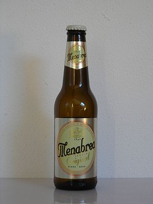
Birra Menabrea
Italian brewing company
Distance: Approx. 5779 meters
Latitude and longitude: 45.571021,8.0499962
Birra Menabrea is an Italian brewing company located in Biella, Piedmont. Under this label - distributed since the early nineties by Birra Forst, but owned by the Thedy family (heir of the founders of the company) - around 100 thousand hectolitres of beer are produced annually, part of which for export to twenty countries.
Biella Synagogue
Distance: Approx. 5287 meters
Latitude and longitude: 45.565491,8.045117
The Biella Synagogue is an early 17th-century synagogue in Biella, Italy. The synagogue occupies the top floor of a medieval house at Vicolo del Bellone 3, in the heart of the historic Jewish quarter. It is a modestly sized, rectangular room with baroque decoration, a central bimah and an ornate, seventeenth century, baroque Torah Ark.
Cossila
Frazione in Piedmont, Italy
Distance: Approx. 5409 meters
Latitude and longitude: 45.5775,8.04194444
Cossila is a neighbourhood of Biella, in Piedmont, northern Italy.
Sacro Monte di Graglia
Type of devotional place in northern Italy
Distance: Approx. 1731 meters
Latitude and longitude: 45.5612,7.9561
The Sacro Monte di Graglia is one of the numerous devotional places around the Italian Alps and it houses the Santuario di Nostra Signora di Loreto, one of the four major sanctuaries of the Biellese territory. Set in the Valle Elvo at 690 m on the sea level, the sanctuary is built near the Lauretana water industry. The complex is a stage of many devotional paths, which include the CoEur - In the heart of European paths and the Path of Saint Charles.

Biella Cathedral
Distance: Approx. 5931 meters
Latitude and longitude: 45.56611111,8.05333333
Biella Cathedral (Italian: Duomo di Biella; Cattedrale di Santo Stefano) is a Roman Catholic cathedral in Biella, Piedmont, Italy, dedicated to Saint Stephen. It is the episcopal seat of the Diocese of Biella.

Parco Burcina Natural Reserve
Distance: Approx. 3598 meters
Latitude and longitude: 45.5817,8.0103
The Burcina Park “Felice Piacenza” Nature Reserve is a protected, wooded, about 57 hectares wide area. It was established in 1980 with a law of the Piedmont Region Government. It is located within the municipalities of Pollone and Biella.

Biella funicular
Distance: Approx. 5480 meters
Latitude and longitude: 45.566922,8.047294
The Biella funicular (Italian: Funicolare di Biella) is a funicular railway in the city of Biella, Piedmont, Italy. It connects a lower station on Via Curiel, in the city's Biella Piano quarter, with an upper station on Via Avogadro in the city's medieval Biella Piazzo quarter. The funicular first opened in December 1885, and was initially operated by water counterbalance.
Weather in this IP's area
clear sky
29 Celsius
35 Celsius
28 Celsius
31 Celsius
1017 hPa
83 %
1017 hPa
953 hPa
10000 meters
0.2 m/s
0.45 m/s
161 degree
6 %
06:07:25
21:01:30