Country:
 France
Region:
City:
Latitude and Longitude:
Time Zone:
Postal Code:
IP information under different IP Channel
ip-api
Country
Region
City
ASN
Time Zone
ISP
Blacklist
Proxy
Latitude
Longitude
Postal
Route
IPinfo
Country
Region
City
ASN
Time Zone
ISP
Blacklist
Proxy
Latitude
Longitude
Postal
Route
MaxMind
Country
Region
City
ASN
Time Zone
ISP
Blacklist
Proxy
Latitude
Longitude
Postal
Route
Luminati
Country
FRASN
Time Zone
Europe/Paris
ISP
Ses Astra S.A.
Latitude
Longitude
Postal
db-ip
Country
Region
City
ASN
Time Zone
ISP
Blacklist
Proxy
Latitude
Longitude
Postal
Route
ipdata
Country
Region
City
ASN
Time Zone
ISP
Blacklist
Proxy
Latitude
Longitude
Postal
Route
Popular places and events near this IP address
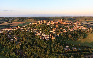
Cordes-sur-Ciel
Commune in Occitania, France
Distance: Approx. 385 meters
Latitude and longitude: 44.0644,1.9536
Cordes-sur-Ciel (French pronunciation: [kɔʁd syʁ sjɛl]; Occitan: Còrdas, [ˈkɔɾðos]) is a commune in the Tarn department, region of Occitania, Southern France. The fortified town was built in 1222 by Raimond VII, the Count of Toulouse, who, though not a Cathar, tolerated what other Catholics considered heresy. Since the late 20th century, the village has become a popular tourist destination.
Mouzieys-Panens
Commune in Occitania, France
Distance: Approx. 3248 meters
Latitude and longitude: 44.0933,1.9333
Mouzieys-Panens is a commune in the Tarn department in southern France.
Labarthe-Bleys
Commune in Occitania, France
Distance: Approx. 3560 meters
Latitude and longitude: 44.0775,1.9081
Labarthe-Bleys is a commune in the Tarn department in southern France.
Livers-Cazelles
Commune in Occitania, France
Distance: Approx. 4195 meters
Latitude and longitude: 44.0531,1.9989
Livers-Cazelles is a commune in the Tarn department in southern France.

Amarens
Commune in Occitania, France
Distance: Approx. 4241 meters
Latitude and longitude: 44.0386,1.9142
Amarens is a commune of the Tarn department in southern France.
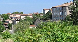
Les Cabannes, Tarn
Commune in Occitania, France
Distance: Approx. 705 meters
Latitude and longitude: 44.0681,1.9414
Les Cabannes (French pronunciation: [le kaban]; Occitan: Las Cabanas) is a commune in the Tarn department in southern France. It has 367 inhabitants in 2020.

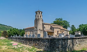
Saint-Marcel-Campes
Commune in Occitania, France
Distance: Approx. 3600 meters
Latitude and longitude: 44.0811,1.9903
Saint-Marcel-Campes (French pronunciation: [sɛ̃ maʁsɛl kɑ̃p]; Occitan: Sent Marcèl e Campas) is a commune in the Tarn department in southern France.
Souel
Commune in Occitania, France
Distance: Approx. 3993 meters
Latitude and longitude: 44.0311,1.9561
Souel (French pronunciation: [swɛl]; Occitan: Soelh) is a commune in the Tarn department and Occitanie region of southern France.
Vindrac-Alayrac
Commune in Occitania, France
Distance: Approx. 2912 meters
Latitude and longitude: 44.0661,1.9136
Vindrac-Alayrac (French pronunciation: [vɛ̃dʁak alɛʁak]; Occitan: Vindrac e Alairac) is a commune in the Tarn department in southern France. The commune is traversed by the Cérou river. Cordes-Vindrac station has rail connections to Toulouse, Figeac and Aurillac.

Bournazel, Tarn
Commune in Occitania, France
Distance: Approx. 3286 meters
Latitude and longitude: 44.0928,1.9692
Bournazel (French pronunciation: [buʁnazɛl]; Occitan: Bornasèl) is a commune in the Tarn department in southern France.
Jardin des Paradis
Distance: Approx. 383 meters
Latitude and longitude: 44.06444444,1.95361111
The Jardin des Paradis (3000 m2) is a private garden located on the Place du Théron, Cordes-sur-Ciel, Tarn, Midi-Pyrénées, France. It has been recognized as a Jardin Remarquable since 2004, and is open daily in the warmer months; an admission fee is charged. The garden was created in 1997 by Eric Ossart and Arnaud Maurières with Brazilian landscape architect Roberto Burle Marx, and opened to the public in 1998.

Cordes-Vindrac station
Railway station in Occitanie, France
Distance: Approx. 4000 meters
Latitude and longitude: 44.0675,1.9
Cordes-Vindrac is a railway station in Vindrac-Alayrac, Occitanie, France. The station is on the Brive-Toulouse (via Capdenac) railway line.
Weather in this IP's area
few clouds
32 Celsius
33 Celsius
32 Celsius
32 Celsius
1013 hPa
47 %
1013 hPa
992 hPa
10000 meters
1.11 m/s
1.46 m/s
227 degree
15 %
06:34:58
21:22:12