Country:
 USA
USARegion:
City:
Latitude and Longitude:
Time Zone:
Postal Code:
IP information under different IP Channel
ip-api
Country
Region
City
ASN
Time Zone
ISP
Blacklist
Proxy
Latitude
Longitude
Postal
Route
IPinfo
Country
Region
City
ASN
Time Zone
ISP
Blacklist
Proxy
Latitude
Longitude
Postal
Route
MaxMind
Country
Region
City
ASN
Time Zone
ISP
Blacklist
Proxy
Latitude
Longitude
Postal
Route
Luminati
Country
USASN
Time Zone
America/Chicago
ISP
UNITAS
Latitude
Longitude
Postal
db-ip
Country
Region
City
ASN
Time Zone
ISP
Blacklist
Proxy
Latitude
Longitude
Postal
Route
ipdata
Country
Region
City
ASN
Time Zone
ISP
Blacklist
Proxy
Latitude
Longitude
Postal
Route
Popular places and events near this IP address

8th Street station (Philadelphia)
Rapid transit station in Philadelphia
Distance: Approx. 173 meters
Latitude and longitude: 39.952076,-75.156612
8th Street station is a subway station complex in Philadelphia, Pennsylvania, at the intersection of 8th Street and Market Street in Center City. It is served by SEPTA's Market–Frankford and Broad–Ridge Spur lines, as well as the PATCO Speedline (signed by SEPTA as the "Lindenwold Line"). The entire complex is owned by SEPTA, while the PATCO areas are leased by the Delaware River Port Authority, which operates that line.
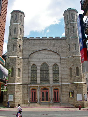
St. Stephen's Episcopal Church (Philadelphia)
Historic church in Pennsylvania, United States
Distance: Approx. 164 meters
Latitude and longitude: 39.950725,-75.15686667
St. Stephen's Episcopal Church is a historic parish of the Episcopal Diocese of Pennsylvania, founded in 1823 in Philadelphia, Pennsylvania and located at 19 South Tenth Street, on the corner of Tenth Street and Ludlow Street. St.

Fashion District Philadelphia
Shopping mall in Pennsylvania, United States
Distance: Approx. 173 meters
Latitude and longitude: 39.952076,-75.156612
Fashion District Philadelphia is a shopping mall in Philadelphia, Pennsylvania, United States, located in Center City along Market Street. It opened in 2019 on the site of a previous mall known as The Gallery and later renamed The Gallery at Market East. The Fashion District Philadelphia anchors currently include Burlington, Primark, AMC Theatres, and Round One Entertainment.
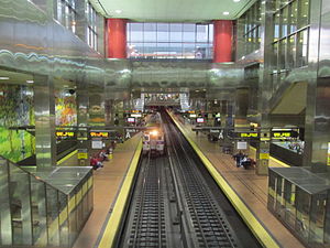
Jefferson Station (SEPTA)
SEPTA Regional Rail station in Philadelphia
Distance: Approx. 130 meters
Latitude and longitude: 39.95263,-75.15811
Jefferson Station (formerly named Market East Station) is an underground SEPTA Regional Rail station located on Market Street in Philadelphia, Pennsylvania. It is the easternmost of the three Center City stations of the SEPTA Regional Rail system and is part of the Center City Commuter Connection, which connects the former Penn Central commuter lines with the former Reading Company commuter lines. In 2014, the station saw approximately 26,000 passengers every weekday.
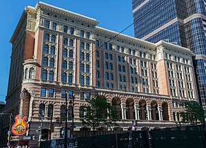
Reading Terminal
Former rail station in Philadelphia
Distance: Approx. 148 meters
Latitude and longitude: 39.95261389,-75.15944444
The Reading Terminal ( RED-ing) is a complex of buildings that includes the former Reading Company main station located in the Market East section of Center City in Philadelphia, Pennsylvania, United States. It comprises the Reading Terminal Headhouse, Trainshed, and Market.

Center City East, Philadelphia
Neighborhood of Philadelphia, PA, US
Distance: Approx. 118 meters
Latitude and longitude: 39.9525,-75.158056
Center City East is part of the downtown district known as Center City, Philadelphia, Pennsylvania, United States. The area is generally bounded by Arch Street to the north, Chestnut Street to the south, Juniper Street to the west, and 6th Street (Independence Mall West) to the east. The area serves as one of the major retail centers in the city as well as the home of the Pennsylvania Convention Center.

Jefferson Tower
High-rise office building located in the Center City section of Philadelphia
Distance: Approx. 67 meters
Latitude and longitude: 39.9521,-75.1585
Jefferson Center, formerly known as the Aramark Tower and One Reading Center, is a high-rise office building located at 1101 Market Street in the Center City section of Philadelphia. The building stands 412 feet (126 meters) tall with 32 floors and is currently the 26th-tallest building in the city. The building was originally conceived by the Reading Company while in a state of bankruptcy as a way to capitalize on its real estate holdings in Center City.

Estey Hall (Philadelphia)
United States historic place
Distance: Approx. 171 meters
Latitude and longitude: 39.95,-75.15805556
Estey Hall, also known as the Allman Building, is a historic building in Philadelphia, Pennsylvania. Estey Hall is a seven-story, commercial building, designed by architects Baker and Dallet, erected by Herbert D. Allman in 1910–11. It was the site from 1911 to 1924 of the Estey Piano Company.

Mercantile Library Company (Philadelphia)
Library in Philadelphia, Pennsylvania, U.S. (1821–1989)
Distance: Approx. 143 meters
Latitude and longitude: 39.9503,-75.1579
The Mercantile Library Company was a library in Philadelphia, Pennsylvania, United States, that operated from 1821 to 1989. Like other "Mercantile Libraries" of the era, it was originally a subscription library focused on serving merchants, but gradually shifted focus over time to serve more as a public library, and ultimately became a freely-accessible branch of the Free Library of Philadelphia. The library moved to three different locations during its 168 years of existence, but only the third library building, opened in 1952, still stands; this building was added to the Philadelphia Register of Historic Places in 1990.

Philadelphia Water Department
Distance: Approx. 67 meters
Latitude and longitude: 39.9521,-75.1585
The Philadelphia Water Department is the public water utility for the City of Philadelphia. PWD provides integrated potable water, wastewater, and stormwater services for Philadelphia and some communities in Bucks, Delaware and Montgomery counties. PWD is a municipal agency of the City of Philadelphia, and is seated in rented space at the Jefferson Tower in the Market East area of Center City, Philadelphia.

East Center City Commercial Historic District
Historic district in Pennsylvania, United States
Distance: Approx. 58 meters
Latitude and longitude: 39.95138889,-75.15916667
The East Center City Commercial Historic District is a national historic district located in the Washington Square neighborhood of Philadelphia, Pennsylvania. It encompasses 287 contributing structures, including large and small commercial buildings, banks, hotels, newspapers, clubs, and restaurants. This district was added to the National Register of Historic Places in 1984, and underwent boundary adjustments in 2018.

Chestnut Street Opera House
Building in Pennsylvania, United States
Distance: Approx. 141 meters
Latitude and longitude: 39.95027778,-75.15805556
The Chestnut Street Opera House was a theatre located at 1021–1029 Chestnut Street in Philadelphia, Pennsylvania. Built by theatre impresario Robert Fox on the former site of the Pennsylvania Academy of the Fine Arts, it opened as a venue for vaudeville in 1870 as Fox's New American Theatre. The theatre was destroyed by fire in 1877 and was rebuilt that same year.
Weather in this IP's area
scattered clouds
32 Celsius
31 Celsius
30 Celsius
33 Celsius
1016 hPa
38 %
1016 hPa
1015 hPa
10000 meters
1.54 m/s
40 %
05:55:49
20:18:12