Country:
 Trinidad & Tobago
Region:
City:
Latitude and Longitude:
Time Zone:
Postal Code:
IP information under different IP Channel
ip-api
Country
Region
City
ASN
Time Zone
ISP
Blacklist
Proxy
Latitude
Longitude
Postal
Route
IPinfo
Country
Region
City
ASN
Time Zone
ISP
Blacklist
Proxy
Latitude
Longitude
Postal
Route
MaxMind
Country
Region
City
ASN
Time Zone
ISP
Blacklist
Proxy
Latitude
Longitude
Postal
Route
Luminati
Country
TTRegion
pos
City
portofspain
ASN
Time Zone
America/Port_of_Spain
ISP
GSL Networks Pty LTD
Latitude
Longitude
Postal
db-ip
Country
Region
City
ASN
Time Zone
ISP
Blacklist
Proxy
Latitude
Longitude
Postal
Route
ipdata
Country
Region
City
ASN
Time Zone
ISP
Blacklist
Proxy
Latitude
Longitude
Postal
Route
Popular places and events near this IP address

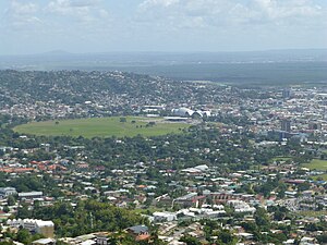
Port of Spain
Capital of Trinidad and Tobago
Distance: Approx. 60 meters
Latitude and longitude: 10.66666667,-61.51666667
Port of Spain, officially the City of Port of Spain (also stylized Port-of-Spain), is the capital of Trinidad and Tobago and the third largest municipality, after Chaguanas and San Fernando. The city has a municipal population of 37,074 (2011), an urban population of 81,142 and a transient daily population of 250,000. It is located on the Gulf of Paria, on the northwest coast of the island of Trinidad and is part of a larger conurbation stretching from Chaguaramas in the west to Arima in the east with an estimated population of 600,000.

Queen's Royal College
School in Port of Spain, Trinidad and Tobago, Trinidad and Tobago
Distance: Approx. 422 meters
Latitude and longitude: 10.6687,-61.5193
Queen's Royal College (St.Clair, Trinidad), referred to for short as QRC, or "The College" by alumni, is a secondary school in Trinidad and Tobago. Originally a boarding school and grammar school, the secular college is selective and noted for its German Renaissance architecture, academic performance and alumni representation in sports, politics and science in Trinidad and Tobago and globally.

National Museum and Art Gallery, Trinidad
Distance: Approx. 762 meters
Latitude and longitude: 10.6629,-61.5103
The National Museum and Art Gallery is the national museum of Trinidad and Tobago, in Port of Spain on Trinidad island. It is located at the top of Frederick Street, opposite the Memorial Park, and just south of the Queen's Park Savannah. The museum was established in 1892, as the Royal Victoria Institute.

Saint James, Trinidad and Tobago
District in Trinidad and Tobago
Distance: Approx. 60 meters
Latitude and longitude: 10.66666667,-61.51666667
Saint James is a district of Port of Spain, Trinidad and Tobago. Port of Spain's last major municipal expansion occurred in 1938, when the St. James district north of Woodbrook and west of St.
Queen's Park Savannah
Distance: Approx. 428 meters
Latitude and longitude: 10.669296,-61.514082
Queen's Park Savannah (QPS) is a park in Port of Spain, Trinidad and Tobago. Known locally as simply "the Savannah", it is Port of Spain's largest open space. It occupies about 260 acres (110 ha) of level land, and the distance around the perimeter is about 2.2 mi (3.5 km).
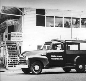
Trinidad Regional Virus Laboratory
Distance: Approx. 60 meters
Latitude and longitude: 10.66666667,-61.51666667
The Trinidad Regional Virus Laboratory (T.R.V.L.) was established in Port of Spain, in 1953 by the Rockefeller Foundation in co-operation with the Government of Trinidad and Tobago. It was originally housed in an old wooden army barracks near the docks in Port of Spain. A large wired-in "animal house" was built out back to house the many wild animals brought in for study.

Roman Catholic Archdiocese of Port of Spain
Latin Catholic ecclesiastical jurisdiction in the Caribbean
Distance: Approx. 65 meters
Latitude and longitude: 10.6667,-61.5167
The Roman Catholic Metropolitan Archdiocese of Port of Spain (Latin: Archidioecesis Metropolitae Portus Hispaniae) is a metropolitan diocese of the Latin Church of the Roman Catholic Church in the Caribbean. The archdiocese encompasses the entirety of the former Spanish dependency of Trinidad, including the islands of Trinidad and Tobago. The archdiocese is the Metropolitan responsible for the suffragan Dioceses of Bridgetown, Georgetown, Paramaribo and Willemstad, and is a member of the Antilles Episcopal Conference.

Bishop Anstey High School
Government School in Trinidad and Tobago
Distance: Approx. 611 meters
Latitude and longitude: 10.66277,-61.51204
Bishop Anstey High School (BAHS), also known as Bishop Anstey or St. Hilary's, is a government-assisted all-girls secondary school in Port of Spain, Trinidad and Tobago. It was founded by the Anglican Bishop Arthur Henry Anstey and opened on January 13, 1921.
College of Science, Technology and Applied Arts of Trinidad and Tobago
College in Trinidad and Tobago
Distance: Approx. 549 meters
Latitude and longitude: 10.66182,-61.51409
The College of Science, Technology and Applied Arts of Trinidad and Tobago (COSTAATT) is a public, multi-campus college in Trinidad and Tobago, established in 2000.

Magnificent Seven (Port of Spain)
Distance: Approx. 605 meters
Latitude and longitude: 10.671,-61.519
The Magnificent Seven is a group of seven mansions located west of the Queen's Park Savannah in northern Port of Spain, Trinidad and Tobago on Maraval Road in the St Clair neighborhood. They were built between 1902 and 1910 on land that was previously used as a government stock farm and are listed as heritage sites at the National Trust of Trinidad and Tobago. Stollmeyer's Castle was the first building in the neighborhood and took several years to complete, as was typical of the Magnificent Seven.
St Clair, Port of Spain
Business and residential district in Port of Spain, Trinidad and Tobago
Distance: Approx. 698 meters
Latitude and longitude: 10.67046111,-61.52107778
Saint Clair is a business and residential district between the Queen's Park Savannah and the Maraval River in Port of Spain, Trinidad and Tobago. It is home to most of the city's grandest and largest mansions and also home to the Magnificent Seven Houses. Federation Park and Ellerslie Park.

Embassy of the United States, Port of Spain
Diplomatic mission
Distance: Approx. 60 meters
Latitude and longitude: 10.66611111,-61.51694444
The Embassy of the United States in Port of Spain is the diplomatic mission of the United States of America in Trinidad and Tobago. Since the inception of diplomatic ties in 1962, Trinidad and Tobago has become one of the most industrialized nations in the English-speaking Caribbean. The embassy processes about 36,000 visa applications per year.
Weather in this IP's area
clear sky
32 Celsius
36 Celsius
32 Celsius
33 Celsius
1013 hPa
57 %
1013 hPa
1010 hPa
10000 meters
4.58 m/s
5.65 m/s
79 degree
6 %
05:54:07
18:30:45