Country:
 USA
USARegion:
City:
Latitude and Longitude:
Time Zone:
Postal Code:
IP information under different IP Channel
ip-api
Country
Region
City
ASN
Time Zone
ISP
Blacklist
Proxy
Latitude
Longitude
Postal
Route
IPinfo
Country
Region
City
ASN
Time Zone
ISP
Blacklist
Proxy
Latitude
Longitude
Postal
Route
MaxMind
Country
Region
City
ASN
Time Zone
ISP
Blacklist
Proxy
Latitude
Longitude
Postal
Route
Luminati
Country
USRegion
fl
City
tallahassee
ASN
Time Zone
America/New_York
ISP
UNITI-FIBER
Latitude
Longitude
Postal
db-ip
Country
Region
City
ASN
Time Zone
ISP
Blacklist
Proxy
Latitude
Longitude
Postal
Route
ipdata
Country
Region
City
ASN
Time Zone
ISP
Blacklist
Proxy
Latitude
Longitude
Postal
Route
Popular places and events near this IP address
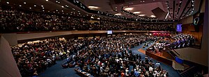
First Baptist Church of Jacksonville
Church in Florida, United States
Distance: Approx. 260 meters
Latitude and longitude: 30.3323,-81.6584
The First Baptist Church of Jacksonville is a Baptist megachurch in Downtown Jacksonville, Florida, U.S.. It is affiliated with the Southern Baptist Convention. As of 2023, First Baptist Church has 2,100 members and an average attendance of around 3,000 for Sunday services.

Rosa Parks Transit Station
Intermodal transit station in Jacksonville, Florida, United States
Distance: Approx. 336 meters
Latitude and longitude: 30.33333333,-81.65888889
Rosa Parks Transit Station is an intermodal transit station in Downtown Jacksonville, Florida. It is operated by the Jacksonville Transportation Authority (JTA) as a station for the Jacksonville Skyway elevated people mover. It previously served as Jacksonville's main city bus station before being replaced by the Jacksonville Regional Transportation Center at LaVilla in May 2020.
Hotel Roosevelt fire
1963 fire in Jacksonville, Florida
Distance: Approx. 477 meters
Latitude and longitude: 30.3284,-81.6582
The Hotel Roosevelt fire on December 29, 1963, was the worst fire that Jacksonville, Florida, had seen since the Great Fire of 1901, and it contributed to the worst one-day death toll in the city's history: 22 people died, mostly from carbon monoxide poisoning. At the time, the Hotel Roosevelt was one of two luxury hotels in the city's downtown, with many restaurants and businesses on its ground floor, including a ballroom and a barber shop. At the end of each year, the Hotel Roosevelt hosted hundreds of travelers who came to attend the Gator Bowl.
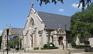
St. John's Cathedral (Jacksonville)
Church in Florida, United States
Distance: Approx. 430 meters
Latitude and longitude: 30.328772,-81.653423
St. John's Cathedral is a cathedral of the Episcopal Church in Jacksonville, Florida, U.S. One of the oldest congregations in Jacksonville, it became the seat of the Bishop of the Episcopal Diocese of Florida in 1951. The current building dates to 1906.
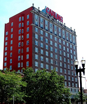
The Carling
United States historic place
Distance: Approx. 476 meters
Latitude and longitude: 30.32833333,-81.65805556
The Carling, formerly known as the Carling Hotel and Hotel Roosevelt, is a historic building in Jacksonville, Florida, United States built in 1925. It is located at 31 West Adams Street in Downtown Jacksonville. As its former names indicates it was originally a hotel, and was used for that purpose until 1964; it currently serves as a residential building.

St. James Building
Historic place in Florida, United States
Distance: Approx. 429 meters
Latitude and longitude: 30.33,-81.65944444
The St. James Building is a historic building in Downtown Jacksonville, Florida, currently housing Jacksonville City Hall. It was designed by architect Henry John Klutho and opened in 1912.

Buckman and Ulmer Building
United States historic place
Distance: Approx. 479 meters
Latitude and longitude: 30.32861111,-81.65277778
The Buckman and Ulmer Building was a historic building in Jacksonville, Florida. It was built in 1925 by Jacksonville architects Marsh & Saxelbye for the Buckman and Ulmer Real Estate Company. It was located at 29-33 West Monroe Street.
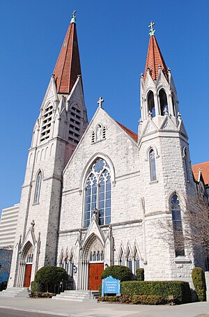
Basilica of the Immaculate Conception (Jacksonville)
Historic church in Florida, United States
Distance: Approx. 360 meters
Latitude and longitude: 30.32888889,-81.65527778
The Basilica of the Immaculate Conception is a historic Catholic church in Downtown Jacksonville, Florida, U.S. A parish church in the Diocese of St. Augustine, it represents Jacksonville's oldest Catholic congregation. The current building, dating to 1910, was added to the U.S. National Register of Historic Places in 1992 as the Church of the Immaculate Conception, and was named a minor basilica in 2013.

Pathway Academy
Charter school in Jacksonville, Florida, United States
Distance: Approx. 398 meters
Latitude and longitude: 30.3337,-81.6594
Pathways Academy is a Charter School located in Jacksonville, Florida, part of the Duval County Public Schools. It is located in the Downtown Campus of Florida State College at Jacksonville at 101 W. State Street, Suite 3001, which is on the top floor at the college. This school is accredited with Southern Association of Colleges and Schools (SACS).

Florida's Tribute to the Women of the Confederacy
Outdoor memorial to Confederate women in Jacksonville, Florida's Springfield Park
Distance: Approx. 324 meters
Latitude and longitude: 30.33481,-81.65447
Florida's Tribute to the Women of the Confederacy, also known as A Tribute to the Women of the Southern Confederacy and the Monument to the Women of the Confederacy, was an outdoor Confederate memorial installed in Jacksonville, Florida's Springfield Park. The memorial was erected in 1915, during the peak of Confederate monument-building, part of widespread campaigns to promote and justify Jim Crow laws in the South. A plaque says the memorial honors women of the Confederate states who "sacrificed their all upon their country's altar" during the Confederacy's 1861-65 war to secede from the United States.
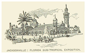
Sub-Tropical Exposition
Exposition held in Jacksonville, Florida, US (1888–1890)
Distance: Approx. 382 meters
Latitude and longitude: 30.3355,-81.6552
The Sub-Tropical Exposition was held from January until May 1888 in Jacksonville, Florida and seasonally in two subsequent years. Grover Cleveland attended the opening. The exposition building was designed by Ellis & McClure.
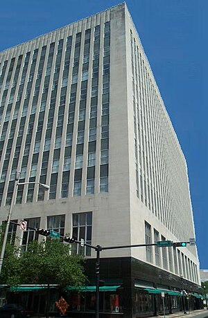
Edward Ball Building
141 feet (43 metres), 11-floor low-rise building in downtown Jacksonville
Distance: Approx. 429 meters
Latitude and longitude: 30.33,-81.65944444
Edward Ball Building is a 141 feet (43 metres), 11-floor office building at 214 North Hogan Street in downtown Jacksonville, Florida. It presently serves as the Jacksonville City Hall Annex, housing several departments that were displaced in 1997 when city government moved to the St. James Building.
Weather in this IP's area
moderate rain
27 Celsius
31 Celsius
25 Celsius
29 Celsius
1015 hPa
88 %
1015 hPa
1014 hPa
10000 meters
4.12 m/s
20 degree
100 %
06:42:11
20:23:49