Country:
 USA
USARegion:
City:
Latitude and Longitude:
Time Zone:
Postal Code:
IP information under different IP Channel
ip-api
Country
Region
City
ASN
Time Zone
ISP
Blacklist
Proxy
Latitude
Longitude
Postal
Route
IPinfo
Country
Region
City
ASN
Time Zone
ISP
Blacklist
Proxy
Latitude
Longitude
Postal
Route
MaxMind
Country
Region
City
ASN
Time Zone
ISP
Blacklist
Proxy
Latitude
Longitude
Postal
Route
Luminati
Country
USRegion
nj
City
clifton
ASN
Time Zone
America/New_York
ISP
DIGITALOCEAN-ASN
Latitude
Longitude
Postal
db-ip
Country
Region
City
ASN
Time Zone
ISP
Blacklist
Proxy
Latitude
Longitude
Postal
Route
ipdata
Country
Region
City
ASN
Time Zone
ISP
Blacklist
Proxy
Latitude
Longitude
Postal
Route
Popular places and events near this IP address

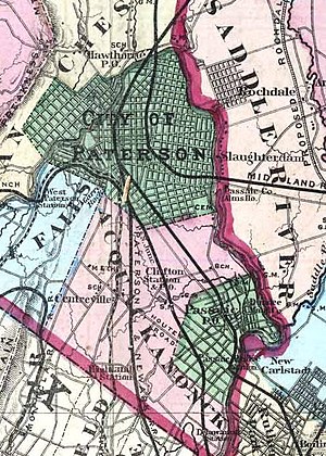
Clifton, New Jersey
City in Passaic County, New Jersey, US
Distance: Approx. 477 meters
Latitude and longitude: 40.862137,-74.160393
Clifton is a city in Passaic County, in the U.S. state of New Jersey. Criss-crossed by several major highways, the city is a regional commercial hub for North Jersey and is a bedroom suburb of New York City in the New York Metropolitan Area. As of the 2020 United States Census, the city retained its position as the state's 11th-most-populous municipality, just behind tenth-ranked Trenton, and well ahead of Cherry Hill in twelfth place, with a population of 90,296, reflecting an overall increase of 6,160 (+7.3%) from the 2010 census count of 84,136, which in turn reflected an overall increase of 5,464 (+6.9%) from the 78,672 counted in the 2000 census.
WPAT (AM)
Multicultural radio station in Paterson, New Jersey (New York City)
Distance: Approx. 1878 meters
Latitude and longitude: 40.84982222,-74.18264444
WPAT (930 AM), is a radio station licensed to Paterson, New Jersey, with a brokered programming format. WPAT is owned by Multicultural Broadcasting, and its studios are located in New York City, in Manhattan's Financial District. The station's four 380 feet (120 m) transmitting towers are located in Clifton, New Jersey.
WNSW
Relevant Radio station in Newark, New Jersey
Distance: Approx. 1913 meters
Latitude and longitude: 40.84972222,-74.18305556
WNSW (1430 AM) is a religious-formatted broadcast radio station, licensed to Newark, New Jersey, and serving the New York Metropolitan area. WNSW has been owned and operated by Relevant Radio, a Roman Catholic radio network, since 2014. It transmits from the four towers leased from WPAT (AM) in Clifton.
Acquackanonk Township, New Jersey
Township in New Jersey, United States
Distance: Approx. 504 meters
Latitude and longitude: 40.86138889,-74.15888889
Acquackanonk Township was a township that existed in New Jersey, United States, from 1693 until 1917, first in Essex County and then in Passaic County.
Clifton Public Schools
Public school district in Passaic County, New Jersey, US
Distance: Approx. 836 meters
Latitude and longitude: 40.865681,-74.160278
The Clifton Public Schools is a comprehensive community public school district that serves students in pre-kindergarten through twelfth grade from Clifton, in Passaic County, in the U.S. state of New Jersey. As of the 2020–21 school year, the district, comprising 18 schools, had an enrollment of 10,514 students and 870.5 classroom teachers (on an FTE basis), for a student–teacher ratio of 12.1:1. The district is classified by the New Jersey Department of Education as being in District Factor Group "CD", the sixth-highest of eight groupings.

Clifton station (NJ Transit)
NJ Transit rail station
Distance: Approx. 1340 meters
Latitude and longitude: 40.8679,-74.1535
Clifton is a New Jersey Transit train station located in Clifton, New Jersey that provides service via the Main Line. The station is located near the intersection of Elm Street, Clifton Terrace, and Clifton Boulevard in Clifton and the tracks form the border between the Athenia and Dutch Hill sections of the city, with the Hoboken-bound platform in the Athenia section and the Suffern-bound platform located in the Dutch Hill section.
Sybase Classic
Golf tournament formerly on the LPGA Tour
Distance: Approx. 1521 meters
Latitude and longitude: 40.848,-74.175
The Sybase Classic was a women's professional golf tournament on the LPGA Tour for twenty years, from 1990 to 2009. The event was originally known as the "Big Apple Classic", but the name was dropped in 2007 when the tournament relocated from the New York City area to New Jersey. From 1992 through 2006, ShopRite sponsored the ShopRite LPGA Classic in Atlantic City.
Clifton High School (New Jersey)
High school in Passaic County, New Jersey, US
Distance: Approx. 1409 meters
Latitude and longitude: 40.871253,-74.163167
Clifton High School (CHS) is a four-year comprehensive public high school serving students in ninth through twelfth grades from the city of Clifton in Passaic County, in the U.S. state of New Jersey, operating as part of the Clifton Public Schools. It has the largest student body in a single facility amongst high schools in New Jersey; Elizabeth High School had more students, but its students have been spread over multiple campuses. As of the 2022–23 school year, the school had an enrollment of 3,059 students and 220.9 classroom teachers (on an FTE basis), for a student–teacher ratio of 13.9:1.
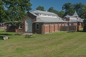
U.S. Animal Quarantine Station
United States historic place
Distance: Approx. 1062 meters
Latitude and longitude: 40.86805556,-74.16194444
The United States Animal Quarantine Station is located in the city of Clifton in Passaic County, New Jersey, United States. The buildings were built in 1900. The facility, considered the Ellis Island for Animals, closed in 1975.
Weasel Brook
Distance: Approx. 2127 meters
Latitude and longitude: 40.87752,-74.16717
Weasel Brook is a tributary of the Passaic River in Passaic County, New Jersey, United States. The brook begins in Clifton, New Jersey's Albion section near Ravine Park, passes under several major roads before it reaches Weasel Brook Park, a Frederick Law Olmsted-designed park named for the brook, where it bisects the park. The brook then goes underground for some time, emerging near Clifton Public School #17 in the Botany section of the city.
Upper Montclair Country Club
Golf course in New Jersey, USA
Distance: Approx. 1549 meters
Latitude and longitude: 40.847726,-74.175075
Upper Montclair Country Club is an A. W. Tillinghast-designed golf course located in Clifton, New Jersey.

Garritse–Doremus–Westervelt House
United States historic place
Distance: Approx. 1982 meters
Latitude and longitude: 40.87097222,-74.14666667
The Garritse–Doremus–Westervelt House, also known as the Vanderhoef–Westervelt House, is a historic Dutch Colonial stone farmhouse located at 794 Park Drive in Weasel Brook Park in the city of Clifton in Passaic County, New Jersey, United States. It was documented by the Historic American Buildings Survey (HABS) in 1939 and was added to the National Register of Historic Places on March 20, 2023, for its significance in architecture. The c. 1785 house is one of the oldest in the county.
Weather in this IP's area
clear sky
20 Celsius
20 Celsius
18 Celsius
22 Celsius
1020 hPa
74 %
1020 hPa
1014 hPa
10000 meters
1.58 m/s
3.29 m/s
267 degree
05:49:31
20:16:32