Country:
 USA
USARegion:
City:
Latitude and Longitude:
Time Zone:
Postal Code:
IP information under different IP Channel
ip-api
Country
Region
City
ASN
Time Zone
ISP
Blacklist
Proxy
Latitude
Longitude
Postal
Route
IPinfo
Country
Region
City
ASN
Time Zone
ISP
Blacklist
Proxy
Latitude
Longitude
Postal
Route
MaxMind
Country
Region
City
ASN
Time Zone
ISP
Blacklist
Proxy
Latitude
Longitude
Postal
Route
Luminati
Country
USRegion
ut
City
orem
ASN
Time Zone
America/Denver
ISP
IW-ASN-11071
Latitude
Longitude
Postal
db-ip
Country
Region
City
ASN
Time Zone
ISP
Blacklist
Proxy
Latitude
Longitude
Postal
Route
ipdata
Country
Region
City
ASN
Time Zone
ISP
Blacklist
Proxy
Latitude
Longitude
Postal
Route
Popular places and events near this IP address

Payson, Utah
City in Utah, United States
Distance: Approx. 619 meters
Latitude and longitude: 40.03888889,-111.73305556
Payson is a city in Utah County, Utah, United States. It is part of the Provo–Orem Metropolitan Statistical Area. The population was 21,101 at the 2020 census.

West Mountain, Utah
CDP in Utah, United States
Distance: Approx. 4792 meters
Latitude and longitude: 40.06305556,-111.78277778
West Mountain is a census-designated place (CDP) in Utah County, Utah, United States. It is part of the Provo–Orem Metropolitan Statistical Area. As of the 2010 census, the CDP population was 1,186.

Mountain View Hospital (Payson, Utah)
Hospital in Utah, United States
Distance: Approx. 1553 meters
Latitude and longitude: 40.04388889,-111.71388889
Mountain View Hospital is a JCAHO accredited, 124-bed hospital in Payson, Utah, which has provided medical care to the south Utah County community from its current location for more than 30 years. The hospital was started in 1914 by Dr. A.L. Curtis above the Wilson Drug Store in Payson.
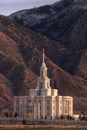
Payson Utah Temple
Distance: Approx. 3173 meters
Latitude and longitude: 40.01875556,-111.74835278
The Payson Utah Temple is a temple of the Church of Jesus Christ of Latter-day Saints in Payson, Utah. The temple is located on the southernmost edge of Utah's Wasatch Front, and is the 15th dedicated temple in the state.
Liberty Safe
American safe manufacturer
Distance: Approx. 1771 meters
Latitude and longitude: 40.043655,-111.752853
Liberty Safe and Security Products, Inc., doing business as Liberty Safe, is a residential and commercial safe manufacturer located in Payson, Utah, United States.
Peteetneet Museum and Cultural Arts Center
United States historic place
Distance: Approx. 756 meters
Latitude and longitude: 40.04333333,-111.72333333
The Peteetneet Museum and Cultural Arts Center is a multi-purpose civic building located in Payson, Utah, United States.

Christopher F. Dixon Jr. House
Historic house in Utah, United States
Distance: Approx. 208 meters
Latitude and longitude: 40.04611111,-111.73111111
The Christopher F. Dixon Jr. House is a historic house located in Payson, Utah, United States. It was listed on the National Register of Historic Places on November 7, 1977.

John Dixon House
Historic house in Utah, United States
Distance: Approx. 171 meters
Latitude and longitude: 40.04583333,-111.73138889
The John Dixon House is a historic house located in Payson, Utah, United States. It was listed on the National Register of Historic Places on February 17, 1978.
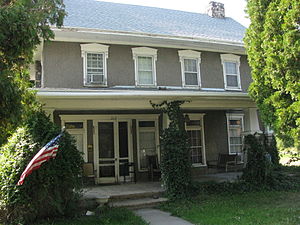
Samuel Douglass House
Historic house in Utah, United States
Distance: Approx. 164 meters
Latitude and longitude: 40.04583333,-111.73166667
The Samuel Douglass House is a historic house located at 215 North Main Street in Payson, Utah, United States. It was updated to include Bungalow/craftsman architecture in 1912, and won a high school civics class award.

Payson Presbyterian Church
Historic church in Utah, United States
Distance: Approx. 1016 meters
Latitude and longitude: 40.03527778,-111.73166667
The Payson Presbyterian Church at 160 South Main Street in Payson, Utah, United States was built in 1882. It has also been known as Payson Bible Church. It was listed on the National Register of Historic Places (NRHP) in 1986; the listing included two contributing buildings.
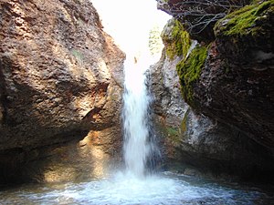
Peteetneet Creek
Stream in Utah County, Utah
Distance: Approx. 1118 meters
Latitude and longitude: 40.03472222,-111.72861111
Peteetneet Creek is a stream in Payson Canyon, south of Payson, Utah, United States.
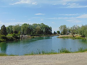
Salem Lake (Utah)
Reservoir in Salem, Utah, United States
Distance: Approx. 4921 meters
Latitude and longitude: 40.051,-111.675
Salem Lake, locally known as Salem Pond, is an 11-acre (4.5 ha) reservoir located in Salem, Utah, United States.
Weather in this IP's area
clear sky
24 Celsius
23 Celsius
22 Celsius
26 Celsius
1009 hPa
37 %
1009 hPa
859 hPa
10000 meters
5.14 m/s
320 degree
06:21:58
20:44:38