Country:
 USA
USARegion:
City:
Latitude and Longitude:
Time Zone:
Postal Code:
IP information under different IP Channel
ip-api
Country
Region
City
ASN
Time Zone
ISP
Blacklist
Proxy
Latitude
Longitude
Postal
Route
IPinfo
Country
Region
City
ASN
Time Zone
ISP
Blacklist
Proxy
Latitude
Longitude
Postal
Route
MaxMind
Country
Region
City
ASN
Time Zone
ISP
Blacklist
Proxy
Latitude
Longitude
Postal
Route
Luminati
Country
USRegion
al
City
talladega
ASN
Time Zone
America/Chicago
ISP
UNITI-FIBER
Latitude
Longitude
Postal
db-ip
Country
Region
City
ASN
Time Zone
ISP
Blacklist
Proxy
Latitude
Longitude
Postal
Route
ipdata
Country
Region
City
ASN
Time Zone
ISP
Blacklist
Proxy
Latitude
Longitude
Postal
Route
Popular places and events near this IP address
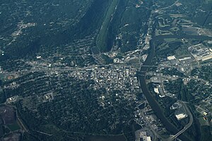
Gadsden, Alabama
City in Alabama, United States
Distance: Approx. 607 meters
Latitude and longitude: 34.01,-86.01027778
Gadsden is a city in and the county seat of Etowah County in the U.S. state of Alabama. It is located on the Coosa River about 56 miles (90 km) northeast of Birmingham and 90 miles (140 km) southwest of Chattanooga, Tennessee. It is the primary city of the Gadsden Metropolitan Statistical Area, which has a population of 103,931.
Congregation Beth Israel (Gadsden, Alabama)
Former synagogue in Gadsden, Alabama, US
Distance: Approx. 406 meters
Latitude and longitude: 34.014076,-86.010783
Congregation Beth Israel (Hebrew: בית ישראל) was a Reform Jewish congregation and synagogue, located for most of its history at 761 Chestnut Street in Gadsden, Alabama, in the United States. An outgrowth of Gadsden's Jewish religious school, it was founded in 1908 and incorporated in 1910. It moved into its Chestnut Street building in 1922, and joined the Union of American Hebrew Congregations in 1924.
Alabama Book Festival
Distance: Approx. 793 meters
Latitude and longitude: 34.01138889,-85.99861111
The Alabama Book Festival is an annual literary festival held since 2006 in Montgomery, Alabama, USA. In the past, it has been sponsored by the Alabama Center for the Book (formerly on the Auburn University campus, in the Caroline Marshall Draughon Center for the Arts & Humanities and now at the University of Alabama). Since 2010, it is underwritten by, among others, the Alabama Writers' Forum, the Alabama Humanities Foundation, the Alabama Library Association, Alabama Public Television, the Alabama State Council on the Arts, New South Books, and Regions Bank. The festival features writers, publishing companies, and local artists, including musicians and print makers.

United States Post Office (Gadsden, Alabama)
United States historic place
Distance: Approx. 25 meters
Latitude and longitude: 34.01444444,-86.00666667
The U.S. Post Office, also known as the Federal Building and Courthouse, is a historic government building in Gadsden, Alabama.

Mort Glosser Amphitheater
United States historic place
Distance: Approx. 818 meters
Latitude and longitude: 34.00833333,-86.00138889
Mort Glosser Amphitheater (formerly known as the Legion Park Bowl and Gadsden Municipal Amphitheatre) is an amphitheatre in Gadsden, Alabama. Built in 1935, it was added to the National Register of Historic Places in 1988.

Eleventh Street School
United States historic place
Distance: Approx. 1079 meters
Latitude and longitude: 34.01361111,-86.01805556
The Eleventh Street School is a historic building in Gadsden, Alabama. Built in 1907, it is the oldest surviving public school in Gadsden. An addition of 8 classrooms, a lunchroom, and two other rooms was added in 1926.

Gadsden Downtown Historic District
Historic district in Alabama, United States
Distance: Approx. 178 meters
Latitude and longitude: 34.01361111,-86.00472222
The Gadsden Downtown Historic District is a historic district in Gadsden, Alabama. The district represents the growth of the town through its industrial heyday from the late 1870s to the late 1940s. The earliest buildings in the district include examples of highly decorated Italianate styles, including the 1904 Gadsden Times-News Building.

Gadsden Times-News Building
United States historic place
Distance: Approx. 335 meters
Latitude and longitude: 34.01222222,-86.00388889
The Gadsden Times-News Building is a historic building in Gadsden, Alabama. It was built by the owners of The Gadsden Times-News in 1904. After changing their name to The Gadsden Times in 1924, the paper moved its operation to another building in 1927.

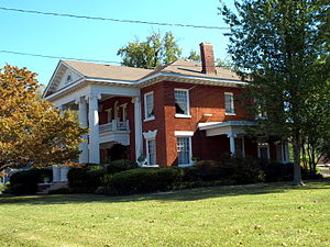
Charles Gunn House
Historic house in Alabama, United States
Distance: Approx. 796 meters
Latitude and longitude: 34.01388889,-86.015
The Charles Gunn House (also known as the Bellenger Home) is a historic residence in Gadsden, Alabama. The house was built in 1886 by Edward Tracy Hollingsworth, a local merchant and banker. Charles Logan Gunn, a dentist, purchased the house in 1901.
Colonel O.R. Hood House
Historic house in Alabama, United States
Distance: Approx. 719 meters
Latitude and longitude: 34.01388889,-86.01416667
The Colonel O. R. Hood House is a historic residence in Gadsden, Alabama. The house was built in 1904 by Oliver Roland Hood, an attorney, politician, industrialist, and one of the founders of the Alabama Power Company. He was also a delegate to the state's 1901 constitutional convention.

Turrentine Historic District
Historic district in Alabama, United States
Distance: Approx. 964 meters
Latitude and longitude: 34.00861111,-86.01416667
The Turrentine Historic District is a historic district in Gadsden, Alabama. The district stretches along Turrentine Avenue and includes houses built during Gadsden's largest period of growth from 1891 through 1934. The street, originally the lane leading from town to the home of General Daniel Clower Turrentine, was home to some of the city's most influential residents, including mayors, bankers, doctors, educators, and industrialists.
Gadsden Coca-Cola Bottling Plant
Historic building in Gadsden, Alabama, U.S.
Distance: Approx. 437 meters
Latitude and longitude: 34.01138889,-86.00944444
The Gadsden Coca-Cola Bottling Plant is a historic building in Gadsden, Alabama. It was built in 1929 by the Coca-Cola Company to replace a facility that had opened in 1915. In 1948–49, a two-story rear addition and one-story wing were built.
Weather in this IP's area
clear sky
23 Celsius
24 Celsius
23 Celsius
24 Celsius
1018 hPa
97 %
1018 hPa
999 hPa
10000 meters
05:52:50
19:47:58