Country:
 Turkey
Region:
City:
Latitude and Longitude:
Time Zone:
Postal Code:
IP information under different IP Channel
ip-api
Country
Region
City
ASN
Time Zone
ISP
Blacklist
Proxy
Latitude
Longitude
Postal
Route
IPinfo
Country
Region
City
ASN
Time Zone
ISP
Blacklist
Proxy
Latitude
Longitude
Postal
Route
MaxMind
Country
Region
City
ASN
Time Zone
ISP
Blacklist
Proxy
Latitude
Longitude
Postal
Route
Luminati
Country
TRRegion
38
City
kayseri
ASN
Time Zone
Europe/Istanbul
ISP
TurkNet Iletisim Hizmetleri A.S.
Latitude
Longitude
Postal
db-ip
Country
Region
City
ASN
Time Zone
ISP
Blacklist
Proxy
Latitude
Longitude
Postal
Route
ipdata
Country
Region
City
ASN
Time Zone
ISP
Blacklist
Proxy
Latitude
Longitude
Postal
Route
Popular places and events near this IP address

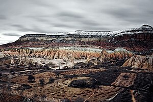
Cappadocia
Historical region in Central Anatolia, Turkey
Distance: Approx. 6000 meters
Latitude and longitude: 38.65833333,34.85361111
Cappadocia (; Turkish: Kapadokya, Greek: Καππαδοκία) is a historical region in Central Anatolia, Turkey. It is largely in the provinces of Nevşehir, Kayseri, Aksaray, Kırşehir, Sivas and Niğde. According to Herodotus, in the time of the Ionian Revolt (499 BC), the Cappadocians were reported as occupying a region from Mount Taurus to the vicinity of the Euxine (Black Sea).

Göreme
Municipality in Nevşehir, Turkey
Distance: Approx. 7380 meters
Latitude and longitude: 38.64305556,34.82888889
Göreme (Turkish: [ɟœˈɾeme]; Ancient Greek: Κόραμα, romanized: Kòrama) is a town (belde) in the Nevşehir District, Nevşehir Province in Central Anatolia, Turkey. Its population is 2,034 (2022). It is well known for its fairy chimneys (Turkish: peribacalar), eroded rock formations, many of which were hollowed out in the Middle Ages to create Christian churches, houses and underground cities.
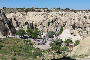
Göreme Historical National Park
National park in Nevşehir, Turkey
Distance: Approx. 4977 meters
Latitude and longitude: 38.65277778,34.86305556
Göreme Historical National Park (pronounced [ˈɟœɾeme]; Turkish: Göreme Tarihî Milli Parkı) is a national park in central Turkey. It occupies an area of nearly 100 km2 (39 sq mi) and is located in Nevşehir Province. It became a UNESCO World Heritage Site in 1985 under the name Goreme National Park and the Rock Sites of Cappadocia.

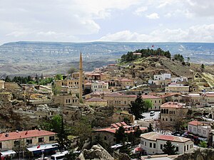
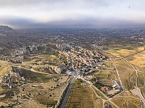
Ürgüp
Municipality in Nevşehir, Turkey
Distance: Approx. 219 meters
Latitude and longitude: 38.63138889,34.91305556
Ürgüp (Greek: Προκόπιο Prokópio, Cappadocian Greek: Προκόπι Prokópi, Ottoman Turkish: Burgut Kalesi) is a town in Nevşehir province in the Cappadocia area of Central Anatolia, Turkey. It is the seat of Ürgüp District. Its population is 24,647 (2022).
Churches of Göreme
Archaeological sites in Turkey
Distance: Approx. 7988 meters
Latitude and longitude: 38.66666667,34.83333333
Göreme is a district of the Nevşehir Province in Turkey. After the eruption of Mount Erciyes about 2.6 million years ago, ash and lava formed soft rocks in the Cappadocia region, covering a region of about 20,000 square kilometres (7,700 sq mi). The softer rock was eroded by wind and water, leaving the hard cap rock on top of pillars, forming the present-day fairy chimneys.

Zelve Monastery
Byzantine-era monastery in Turkey
Distance: Approx. 7988 meters
Latitude and longitude: 38.66666667,34.83333333
The Zelve Monastery is a Byzantine-era monastery that was carved into the rock in pre-iconoclastic times. It is part of the Zelve Open Air Museum, located between Ürgüp and Avanos, Turkey.
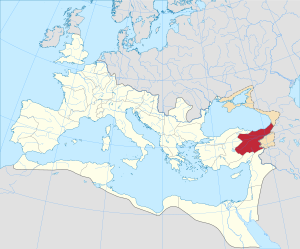
Cappadocia (Roman province)
Roman province located in modern-day Turkey
Distance: Approx. 7803 meters
Latitude and longitude: 38.6706,34.8392
Cappadocia was a province of the Roman Empire in Anatolia (modern central-eastern Turkey), with its capital at Caesarea. It was established in 17 AD by the Emperor Tiberius (ruled 14–37 AD), following the death of Cappadocia's last king, Archelaus. Cappadocia was an imperial province, meaning that its governor (legatus Augusti) was directly appointed by the emperor.
Mustafapaşa, Ürgüp
Village in Nevşehir, Turkey
Distance: Approx. 4967 meters
Latitude and longitude: 38.58638889,34.89777778
Mustafapaşa, formerly known as Sinasos (Greek: Σινασός), is a village in the Ürgüp District of Nevşehir Province, Turkey. Its population is 1,295 (2022). Before the 2013 reorganisation, it was a town (belde).
Çavuşin
Village in Nevşehir, Turkey
Distance: Approx. 7935 meters
Latitude and longitude: 38.6728,34.8394
Çavuşin is a village in the Avanos District in Nevşehir Province in the Cappadocia region of Turkey. Its population is 421 (2022). It is on the road between Avanos and Göreme, about five kilometres north of Göreme.

Medrese of Mehmet Şakir Paşa
Islamic education institute
Distance: Approx. 5297 meters
Latitude and longitude: 38.58333333,34.89777778
Medrese of Mehmet Şakir Paşa, also known as Madrasa of Mustafapaşa is a 19th-century madrasa, an Islamic educational institute, in Nevşehir Province, central Turkey. It is also known as a caravanserai. The madrasa is in Mustafapaşa, formerly Sinasos, in Ürgüp District of Nevşehir Province.
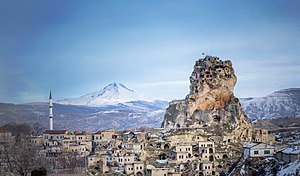
Ortahisar, Nevşehir
Municipality in Nevşehir, Turkey
Distance: Approx. 4226 meters
Latitude and longitude: 38.62083333,34.86472222
Ortahisar (Turkish: Middle Castle), previously known by its Byzantine name Potamía (Greek: Ποταμία), is a town (belde) in the Ürgüp District, Nevşehir Province, Turkey. Its population is 3,086 (2022). Ortahisar is located about 20 km east of the provincial capital, Nevşehir.
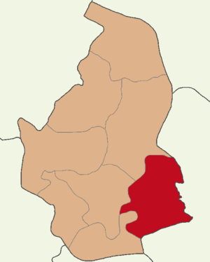
Ürgüp District
District of Nevşehir Province, Turkey
Distance: Approx. 581 meters
Latitude and longitude: 38.63333333,34.91666667
Ürgüp District is a district of the Nevşehir Province of Turkey. Its seat is the town of Ürgüp. Its area is 587 km2, and its population is 36,695 (2022)..
Weather in this IP's area
broken clouds
24 Celsius
24 Celsius
24 Celsius
24 Celsius
1011 hPa
34 %
1011 hPa
895 hPa
10000 meters
6.26 m/s
8.73 m/s
335 degree
55 %
05:37:39
19:55:49