Country:
 Turkey
Region:
City:
Latitude and Longitude:
Time Zone:
Postal Code:
IP information under different IP Channel
ip-api
Country
Region
City
ASN
Time Zone
ISP
Blacklist
Proxy
Latitude
Longitude
Postal
Route
IPinfo
Country
Region
City
ASN
Time Zone
ISP
Blacklist
Proxy
Latitude
Longitude
Postal
Route
MaxMind
Country
Region
City
ASN
Time Zone
ISP
Blacklist
Proxy
Latitude
Longitude
Postal
Route
Luminati
Country
TRRegion
06
City
ankara
ASN
Time Zone
Europe/Istanbul
ISP
TurkNet Iletisim Hizmetleri A.S.
Latitude
Longitude
Postal
db-ip
Country
Region
City
ASN
Time Zone
ISP
Blacklist
Proxy
Latitude
Longitude
Postal
Route
ipdata
Country
Region
City
ASN
Time Zone
ISP
Blacklist
Proxy
Latitude
Longitude
Postal
Route
Popular places and events near this IP address
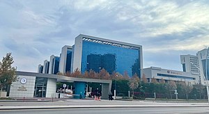
Council of State (Turkey)
Highest administrative court in Turkey
Distance: Approx. 571 meters
Latitude and longitude: 39.925,32.85361111
The Council of State (Turkish: Danıştay) is the highest administrative court in the Republic of Turkey and is located in Ankara. Its role and tasks are prescribed by the Constitution of Turkey within the articles on the supreme courts. According to Article 155 of the Turkish Constitution (1982), "The Council of State is the last instance for reviewing decisions and judgments given by administrative courts and not referred by law to other administrative courts.

Turkey
Country in West Asia and Southeast Europe
Distance: Approx. 514 meters
Latitude and longitude: 39.91666667,32.85
Turkey, officially the Republic of Türkiye, is a country mainly in Anatolia in West Asia, with a smaller part called East Thrace in Southeast Europe. It borders the Black Sea to the north; Georgia, Armenia, Azerbaijan, and Iran to the east; Iraq, Syria, and the Mediterranean Sea (and Cyprus) to the south; and the Aegean Sea, Greece, and Bulgaria to the west. Turkey is home to over 85 million people; most are ethnic Turks, while ethnic Kurds are the largest ethnic minority.
125th Anniversary Çayyolu Stage
Distance: Approx. 102 meters
Latitude and longitude: 39.9208,32.8541
125th Anniversary Çayyolu Stage (Turkish: 125. Yıl Çayyolu Sahnesi), is a theatre in Çayyolu suburb of Çankaya district in Ankara, Turkey. It is operated by the Turkish State Theatres.
Kızılay, Ankara
Neighbourhood in Çankaya, Ankara, Turkey
Distance: Approx. 514 meters
Latitude and longitude: 39.91666667,32.85
Kızılay is the city center of Ankara Province in the municipality and district of Çankaya, Turkey. Its population is 1,311 (2022). It is named after the Kızılay Derneği (Turkish Red Crescent) whose former headquarters was located at the Kızılay Square.

Kahramanlar Business Center
A building in Ankara, Turley
Distance: Approx. 55 meters
Latitude and longitude: 39.92027778,32.85472222
Kahramanlar Business Center (Turkish: Kahramanlar İş Merkezi), originally known between 1959 and 2015 as Emek Business Center (Turkish: Emek İşhanı), is a 24 storey highrise building at Kızılay Square in Ankara, Turkey. Inspired by the Lever House building in New York City, it was designed in 1959 as one of the first International Style highrise buildings in Turkey. At the time of its completion in 1965, it was the tallest building in Ankara.

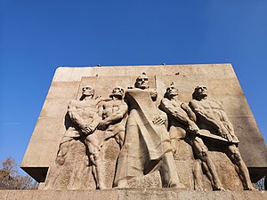
March 2016 Ankara bombing
Terrorist attack in Ankara, Turkey, by Kurdish militants
Distance: Approx. 61 meters
Latitude and longitude: 39.92,32.8536
The March 2016 Ankara bombing killed at least 37 people and injured 125. Of the 125 individuals who suffered injuries, 19 of them were seriously harmed. Several buildings were also damaged during the event, and a bus and many cars were reportedly completely destroyed.

Güvenpark
Park in Kızılay, Ankara, Turkey
Distance: Approx. 115 meters
Latitude and longitude: 39.9193,32.8532
Güvenpark or Güven Park (literally: Trust Park), is an urban public park located adjacent to the Liberty Square in the Kızılay neighborhood of Ankara in Turkey. Established in the 1930s as part of the green belts proposed in the urban plan of the rapid growing capital, the park is noted for the Security Monument. In mid-March 2016, a bomb explosion close to it caused the death of more than 30 people while over 100 were injured.

Gazi Mustafa Kemal Boulevard, Ankara
Distance: Approx. 581 meters
Latitude and longitude: 39.92333333,32.84916667
Gazi Mustafa Kemal Boulevard (Turkish: Gazi Mustafa Kemal Bulvarı), abbreviated as GMK Boulevard, is a boulevard connecting Anadolu Square (formerly: Tandoğan Square) in Yenimahalle with Kızılay Square in Çankaya of Ankara, Turkey. The 2.2 km (1.4 mi) long boulevard runs in northwest–southeast direction. It is named after Mustafa Kemal Atatürk (1881–1938), the founder of Turkish Republic.
Hittite Sun Course Monument
Memorial in Sıhhiye Square, Ankara, Turkey
Distance: Approx. 624 meters
Latitude and longitude: 39.9255,32.8541
The Hittite Sun Disc Monument (Turkish: Hitit Güneş Kursu Anıtı) is a memorial dedicated to Hittites created by sculptor Nusret Suman and placed in Sıhhiye Square, Ankara, Turkey, in 1978.

15 Temmuz Kızılay Milli İrade (Ankara Metro)
Distance: Approx. 103 meters
Latitude and longitude: 39.9208,32.854
15 Temmuz Kızılay Millî İrade, formerly known and still commonly referred to as just Kızılay, is an underground station and a hub of the Ankara Metro. A total of four lines meet at Kızılay; Ankaray, the M1, the M2, and the M4. The station was first opened on 30 August 1996 with the Ankaray platform, while the M1 platform was opened on 29 December 1997.
Human Rights and Equality Institution of Turkey
Human rights watchdog
Distance: Approx. 351 meters
Latitude and longitude: 39.92016667,32.85839444
The Human Rights and Equality Institution of Türkiye (Turkish: Türkiye İnsan Hakları ve Eşitlik Kurumu, TİHEK) is the equality body and the national human rights institution of Turkey. It is a public legal entity vested with administrative and financial autonomy by the relevant legislation regulating it.
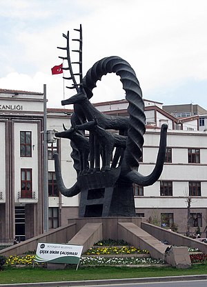
Security Monument
Sculpture in Ankara
Distance: Approx. 79 meters
Latitude and longitude: 39.91998,32.85338
Security Monument Güvenlik Anıtı (Turkish) is installed in Güvenpark of Ankara, Turkey. It was built in 1935. The sculpture is a gratuity to the Turkish police.
Weather in this IP's area
clear sky
19 Celsius
19 Celsius
19 Celsius
19 Celsius
1013 hPa
74 %
1013 hPa
915 hPa
10000 meters
1.34 m/s
2.24 m/s
273 degree
05:42:40
20:07:16