Country:
 Turkey
Region:
City:
Latitude and Longitude:
Time Zone:
Postal Code:
IP information under different IP Channel
ip-api
Country
Region
City
ASN
Time Zone
ISP
Blacklist
Proxy
Latitude
Longitude
Postal
Route
IPinfo
Country
Region
City
ASN
Time Zone
ISP
Blacklist
Proxy
Latitude
Longitude
Postal
Route
MaxMind
Country
Region
City
ASN
Time Zone
ISP
Blacklist
Proxy
Latitude
Longitude
Postal
Route
Luminati
Country
TRRegion
34
City
istanbul
ASN
Time Zone
Europe/Istanbul
ISP
TurkNet Iletisim Hizmetleri A.S.
Latitude
Longitude
Postal
db-ip
Country
Region
City
ASN
Time Zone
ISP
Blacklist
Proxy
Latitude
Longitude
Postal
Route
ipdata
Country
Region
City
ASN
Time Zone
ISP
Blacklist
Proxy
Latitude
Longitude
Postal
Route
Popular places and events near this IP address
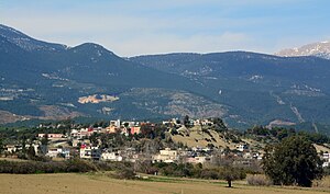
Karaisalı
District and municipality in Adana, Turkey
Distance: Approx. 501 meters
Latitude and longitude: 37.26111111,35.06
Karaisalı is a municipality and district of Adana Province, Turkey. Its area is 1,165 km2, and its population is 22,042 (2022). The area contains the reservoirs of Çatalan and Nergizlik.
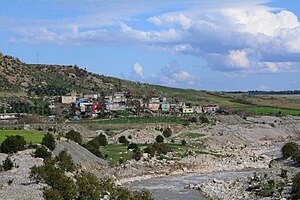
Nergizlik Dam
Dam in Turkey
Distance: Approx. 4851 meters
Latitude and longitude: 37.2995,35.0486
Nergizlik Dam is a dam in Adana Province, Turkey. The development was backed by the Turkish State Hydraulic Works.
Aktaş, Karaisalı
Neighbourhood in Karaisalı, Adana, Turkey
Distance: Approx. 1983 meters
Latitude and longitude: 37.268,35.0762
Aktaş is a neighbourhood in the municipality and district of Karaisalı, Adana Province, Turkey. Its population is 94 (2022).
Ayakkıf, Karaisalı
Neighbourhood in Karaisalı, Adana, Turkey
Distance: Approx. 6788 meters
Latitude and longitude: 37.21666667,35.11666667
Ayakkıf is a neighbourhood in the municipality and district of Karaisalı, Adana Province, Turkey. Its population is 311 (2022).
Aşağıbelemedik, Karaisalı
Neighbourhood in Karaisalı, Adana, Turkey
Distance: Approx. 2522 meters
Latitude and longitude: 37.26666667,35.03333333
Aşağıbelemedik is a neighbourhood in the municipality and district of Karaisalı, Adana Province, Turkey. Its population is 53 (2022).
Aşağıyörükler, Karaisalı
Neighbourhood in Karaisalı, Adana, Turkey
Distance: Approx. 2519 meters
Latitude and longitude: 37.2789,35.0644
Aşağıyörükler is a neighbourhood in the municipality and district of Karaisalı, Adana Province, Turkey. Its population is 97 (2022).
Başkıf, Karaisalı
Neighbourhood in Karaisalı, Adana, Turkey
Distance: Approx. 5237 meters
Latitude and longitude: 37.26666667,35.11666667
Başkıf is a neighbourhood in the municipality and district of Karaisalı, Adana Province, Turkey. Its population is 181 (2022).
Gülüşlü, Karaisalı
Neighbourhood in Karaisalı, Adana, Turkey
Distance: Approx. 4774 meters
Latitude and longitude: 37.28333333,35.01666667
Gülüşlü is a neighbourhood in the municipality and district of Karaisalı, Adana Province, Turkey. Its population is 93 (2022).
Güvenç, Karaisalı
Neighbourhood in Karaisalı, Adana, Turkey
Distance: Approx. 3496 meters
Latitude and longitude: 37.2284,35.076
Güvenç is a neighbourhood in the municipality and district of Karaisalı, Adana Province, Turkey. Its population is 290 (2022).
Kapıkaya, Karaisalı
Neighbourhood in Karaisalı, Adana, Turkey
Distance: Approx. 4557 meters
Latitude and longitude: 37.2333,35.0167
Kapıkaya is a neighbourhood in the municipality and district of Karaisalı, Adana Province, Turkey. Its population is 135 (2022). Kapıkaya Canyon is to the north of the village.
Maraşlı, Karaisalı
Neighbourhood in Karaisalı, Adana, Turkey
Distance: Approx. 5671 meters
Latitude and longitude: 37.3025,35.08694444
Maraşlı is a neighbourhood in the municipality and district of Karaisalı, Adana Province, Turkey. Its population is 245 (2022).
Nergizlik, Karaisalı
Neighbourhood in Karaisalı, Adana, Turkey
Distance: Approx. 5818 meters
Latitude and longitude: 37.30694444,35.04083333
Nergizlik is a neighbourhood in the municipality and district of Karaisalı, Adana Province, Turkey. Its population is 202 (2022). The village is inhabited by Tahtacı.
Weather in this IP's area
clear sky
27 Celsius
27 Celsius
27 Celsius
29 Celsius
1008 hPa
40 %
1008 hPa
977 hPa
10000 meters
2.87 m/s
3.34 m/s
310 degree
05:40:21
19:51:57