Country:
 Turkey
Region:
City:
Latitude and Longitude:
Time Zone:
Postal Code:
IP information under different IP Channel
ip-api
Country
Region
City
ASN
Time Zone
ISP
Blacklist
Proxy
Latitude
Longitude
Postal
Route
IPinfo
Country
Region
City
ASN
Time Zone
ISP
Blacklist
Proxy
Latitude
Longitude
Postal
Route
MaxMind
Country
Region
City
ASN
Time Zone
ISP
Blacklist
Proxy
Latitude
Longitude
Postal
Route
Luminati
Country
TRRegion
41
City
kosekoy
ASN
Time Zone
Europe/Istanbul
ISP
TurkNet Iletisim Hizmetleri A.S.
Latitude
Longitude
Postal
db-ip
Country
Region
City
ASN
Time Zone
ISP
Blacklist
Proxy
Latitude
Longitude
Postal
Route
ipdata
Country
Region
City
ASN
Time Zone
ISP
Blacklist
Proxy
Latitude
Longitude
Postal
Route
Popular places and events near this IP address

Adana
City in Turkey
Distance: Approx. 697 meters
Latitude and longitude: 37,35.32133333
Adana is a large city in southern Turkey. The city is situated on the Seyhan River, 35 km (22 mi) inland from the northeastern shores of the Mediterranean Sea. It is the administrative seat of the Adana province, and has a population of 1.8 million, making it the largest city in the Mediterrenean Region.

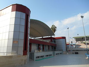
Adana 5 Ocak Stadium
Distance: Approx. 345 meters
Latitude and longitude: 36.99888889,35.32972222
The Adana 5 Ocak Fatih Terim Stadium (Turkish: Adana 5 Ocak Stadı) was a multi-purpose stadium in Adana, Turkey. It was opened in 1938, together with the Menderes Sports Hall and Gençlik Stadium as a sports complex, at the new neighborhood of Reşatbey. The stadium holds 16,095, with a large East and West stands and much smaller North and South stands.

Merkez Park
Park in Adana, Turkey
Distance: Approx. 896 meters
Latitude and longitude: 36.99555556,35.335
Merkez Park (English: Central Park) is a 33-hectare (82-acre) urban park that is located on both banks of the Seyhan River in Adana. The larger portion of the park, 30 hectares (74 acres), is on the west bank. Merkez Park starts just north of Sabancı Mosque and extends north to Galleria Shopping Mall.

Demirköprü (bridge)
Bridge in Adana, Turkey
Distance: Approx. 830 meters
Latitude and longitude: 37.007358,35.335165
Demirköprü (literally iron bridge) is a railway bridge spanning the Seyhan River in Adana. Opened in 1912, it extends 530 meters between Reşatbey and Sinanpaşa neighborhoods. Demirköprü is a steel bridge constructed by German Engineers in part of the Berlin-Baghdad Railway project.

Adana railway station
Railway station of Adana, Turkey
Distance: Approx. 877 meters
Latitude and longitude: 37.00361111,35.31916667
Adana station (Turkish: Adana garı) is a railway station in Adana and one of the major railway hubs in Turkey. The station is located at the İstasyon Square, in Kurtuluş, Seyhan. The Central Station is steps away from the Vilayet Metro station and the Adana Province Hall.
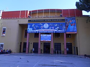
Menderes Sports Hall
Distance: Approx. 302 meters
Latitude and longitude: 36.99972222,35.33083333
Menderes Sports Hall is a multi-purpose indoor arena located in Adana, situated just next to the 5 Ocak Stadium. The arena is opened in 1938 together with the stadium as a sports complex. The sports hall has an audience capacity of 2000.
Atatürk Swimming Complex
Olympic-size swimming pools and centre in Adana, Southern Turkey
Distance: Approx. 958 meters
Latitude and longitude: 36.99611111,35.32083333
The Atatürk Swimming Complex is a swimming centre in Adana, featuring two outdoor Olympic-size swimming pools and an indoor semi-Olympic-size swimming pool. The building was opened in 1936, and re-constructed in 2009 at a cost of 6.5 million TL. The complex was the venue of the Adana Demirspor waterpolo team. Olympic length Atatürk swimming pool features: 10-lane 2.4 depth 5.5m high 3-storey diving tower (with elevator) 2200-seater Spectator Stands with Shelter Olympic length outdoor 100.Yıl swimming pool features: 10-lane 2.4 depth Spectator Stands with Shelter Semi-olympic length indoor swimming pool features: 5-lane 1.8m depth In addition, the fitness centre is equipped with cardiovascular conditioning equipment, strength training equipment, and free weights.

Adana İdman Yurdu
Football club
Distance: Approx. 345 meters
Latitude and longitude: 36.99888889,35.32972222
Adana İdman Yurdu (Turkish: Adana İdmanyurdu Kadın Futbol Takımı) was a women's association football team based in Adana, Turkey. The club was merged with Adana Demirspor in August 2022 and the women's football department formed the Adana Demirspor's women football department. The team played in the Turkish Women's Football Super League.
Reşatbey
Neighbourhood in Seyhan, Adana, Turkey
Distance: Approx. 842 meters
Latitude and longitude: 36.99444444,35.32722222
Reşatbey (Turkish pronunciation: [ɾeʃatbej]) is a neighbourhood (mahalle) in the municipality and district of Seyhan, Adana Province, Turkey. Its population is 11,751 (2022). The neighbourhood is part of the downtown, situated north of the D400 state road and west of the Seyhan River.

Gençlik Stadium
Football stadium in Reşatbey, Adana
Distance: Approx. 393 meters
Latitude and longitude: 36.99888889,35.33111111
Gençlik Stadium (Turkish: Gençlik Stadı) is a football stadium in the Reşatbey neighborhood of the city of Adana. The stadium is opened in 1938, together with the 5 Ocak Stadium and the Menderes Sports Hall, as a sports complex. The stadium has a capacity of 2000 spectators with an only East Stand.
Kurtuluş, Seyhan
Neighbourhood in Seyhan, Adana, Turkey
Distance: Approx. 748 meters
Latitude and longitude: 37.00055556,35.32055556
Kurtuluş (Turkish pronunciation: [kuɾtulush]) is a neighbourhood (mahalle) in the municipality and district of Seyhan, Adana Province, Turkey. Its population is 11,444 (2022). The neighborhood is part of the downtown of Adana, situated south of the railway lines and east of the Adana Metro line.
İstiklal, Seyhan
Neighbourhood in Seyhan, Adana, Turkey
Distance: Approx. 842 meters
Latitude and longitude: 36.99444444,35.32722222
İstiklal is a historical neighbourhood (mahalle) in the municipality and district of Seyhan, Adana Province, Turkey. Its population is 6,137 (2022). The neighbourhood is part of the downtown of Adana, situated south of the D400 state road and east of the Adana Metro line.
Weather in this IP's area
clear sky
28 Celsius
32 Celsius
25 Celsius
28 Celsius
1007 hPa
78 %
1007 hPa
1003 hPa
10000 meters
3.09 m/s
50 degree
05:40:40
19:49:27