Country:
 Turkey
Region:
City:
Latitude and Longitude:
Time Zone:
Postal Code:
IP information under different IP Channel
ip-api
Country
Region
City
ASN
Time Zone
ISP
Blacklist
Proxy
Latitude
Longitude
Postal
Route
IPinfo
Country
Region
City
ASN
Time Zone
ISP
Blacklist
Proxy
Latitude
Longitude
Postal
Route
MaxMind
Country
Region
City
ASN
Time Zone
ISP
Blacklist
Proxy
Latitude
Longitude
Postal
Route
Luminati
Country
TRRegion
41
City
kosekoy
ASN
Time Zone
Europe/Istanbul
ISP
TurkNet Iletisim Hizmetleri A.S.
Latitude
Longitude
Postal
db-ip
Country
Region
City
ASN
Time Zone
ISP
Blacklist
Proxy
Latitude
Longitude
Postal
Route
ipdata
Country
Region
City
ASN
Time Zone
ISP
Blacklist
Proxy
Latitude
Longitude
Postal
Route
Popular places and events near this IP address
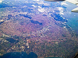
Gebze
District and municipality in Kocaeli, Turkey
Distance: Approx. 364 meters
Latitude and longitude: 40.8,29.43333333
Gebze (Turkish pronunciation: [ˈɟebze]), formerly known as Libyssa, is a municipality and district of Kocaeli Province, Turkey. Its area is 418 km2, and its population is 407,019 (2022). It is situated 65 km (30 mi) southeast of Istanbul, on the Gulf of Izmit, the eastern arm of the Sea of Marmara.
Turkish National Research Institute of Electronics and Cryptology
Distance: Approx. 2313 meters
Latitude and longitude: 40.78583333,29.44694444
The National Research Institute of Electronics and Cryptology of Turkey (Turkish: Ulusal Elektronik ve Kriptoloji Araştırma Enstitüsü), shortly UEKAE, is a national scientific organization with the aim of developing advanced technologies for information security. UEKAE is the most prominent and also the founder (first) institute of the TÜBİTAK. The institute was founded by Yılmaz Tokad, professor at ITU (Istanbul Technical University), and four researchers under his supervision in the building of engineering at METU (Middle East Technical University)in 1972, with the name Electronic Research Unit. In 1995 the institute's name has become National Research Institute of Electronics and Cryptology and moved to Gebze, Kocaeli.

TEV İnanç Türkeş High School for Gifted Students
School in Gebze, Kocaeli, Turkey
Distance: Approx. 4948 meters
Latitude and longitude: 40.782296,29.483185
TEV İnanç Türkeş High School for Gifted Students (Turkish: TEV İnanç Türkeş Özel Lisesi) is an independent private co-educational boarding school for the gifted and talented in Turkey.

Gebze railway station
Distance: Approx. 2711 meters
Latitude and longitude: 40.78388889,29.41083333
Gebze station (Turkish: Gebze garı) is a station on the Istanbul-Ankara railway in Gebze, Turkey. It is located between Plevne and Etem Paşa Avenues just southwest of Gebze's city center. It was the eastern terminus of the Haydarpaşa suburban commuter service until 2013 and in 2019 became the eastern terminus of the new Marmaray commuter rail line.

Çayırova, Kocaeli
District and municipality in Kocaeli, Turkey
Distance: Approx. 1256 meters
Latitude and longitude: 40.8,29.41666667
Çayırova is a municipality and district of Kocaeli Province, Turkey. Its area is 23 km2, and its population is 150,792 (2022). The district Çayırova was created in 2008 from part of the district of Gebze, along with the districts Darıca and Dilovası.
TÜBİTAK Marmara Research Center
Distance: Approx. 2450 meters
Latitude and longitude: 40.78555556,29.44916667
The TÜBİTAK Marmara Research Center (Turkish: TÜBİTAK Marmara Araştırma Merkezi), shortly TÜBİTAK MAM, is a Turkish scientific and technological center carrying out research projects through its subordinate institutes on basic and applied science fields in the area of industrial needs to contribute to the increase of the global competitive power of the country. It was established in 1972 by the Scientific and Technological Research Council of Turkey (Turkish: Türkiye Bilimsel ve Teknolojik Araştırma Kurumu, TÜBİTAK) in Gebze, Kocaeli Province bringing a number of research units of TÜBİTAK formed in the past under one umbrella. The center is currently headed by Prof.

TÜBİTAK Informatics and Information Security Research Center
Distance: Approx. 2313 meters
Latitude and longitude: 40.78583333,29.44694444
The TÜBİTAK Informatics and Information Security Research Center (Turkish: TÜBİTAK Bilişim ve Bilgi Güvenliği İleri Teknolojiler Araştırma Merkezi), shortly TÜBİTAK BİLGEM, is a Turkish scientific and technological center carrying out research projects through its subordinate institutes on various fields of informatics. It was established in 2010 by the Scientific and Technological Research Council of Turkey (Turkish: Türkiye Bilimsel ve Teknolojik Araştırma Kurumu, TÜBİTAK) in Gebze, Kocaeli Province as an umbrella institution of the existing Information Technologies Institute (BTE) and National Research Institute of Electronics and Cryptology (UEKAE) following their transfer from the TÜBİTAK Marmara Research Center.

Fatih railway station
Distance: Approx. 5678 meters
Latitude and longitude: 40.8075,29.364
Gebze Teknik Üniversitesi – Fatih station (Turkish: Gebze Teknik Üniversitesi - Fatih istasyonu) is a station on the Marmaray commuter rail line in Gebze, Turkey. The station, along with Çayırova, is situated inside the Gebze Technical University campus. Commuter rail service resumed on 13 March 2019.
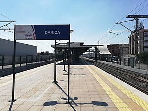
Darıca railway station
Distance: Approx. 3547 meters
Latitude and longitude: 40.7914,29.3918
Darıca station (Turkish: Darıca istasyonu) is a station on the Marmaray commuter rail in Darıca, Turkey. It is a new station that has been added to the railway with the Marmaray project. Construction of the station started in 2013 and was structurally completed in 2014, along with the other eight stations located between Pendik and Gebze.

Osmangazi railway station
Distance: Approx. 4325 meters
Latitude and longitude: 40.7992,29.38
Osmangazi station (Turkish: Osmangazi istasyonu) is a station on the Marmaray commuter rail line in Gebze, Turkey. It was previously a station on the Haydarpaşa suburban until 2013, when commuter rail service was suspended. The original station was opened in 1954 with two side platforms and demolished in 2013.
Dacibyza
Town of ancient Bithynia
Distance: Approx. 391 meters
Latitude and longitude: 40.799732,29.433368
Dacibyza or Dakibyza (Ancient Greek: Δακίβυζα), or Dacibyze or Dakibyze (Δακιβύζη), was a town of ancient Bithynia located on the road from Libyssa to Chalcedon on the north coast of the Sinus Astacenus, an arm of the Propontis. Its site is located near Gebze, in Asiatic Turkey.
Potamoi (Bithynia)
Town of ancient Bithynia
Distance: Approx. 4349 meters
Latitude and longitude: 40.798384,29.379823
Potamoi (Ancient Greek: Ποταμοί) was a town of ancient Bithynia located on the road from Libyssa to Chalcedon on the north coast of the Sinus Astacenus, an arm of the Propontis. Its site is located east of Pendik, in Asiatic Turkey.
Weather in this IP's area
scattered clouds
26 Celsius
26 Celsius
25 Celsius
27 Celsius
1016 hPa
65 %
1016 hPa
997 hPa
10000 meters
5.66 m/s
30 degree
40 %
05:54:04
20:23:15