Country:
 Turkey
Region:
City:
Latitude and Longitude:
Time Zone:
Postal Code:
IP information under different IP Channel
ip-api
Country
Region
City
ASN
Time Zone
ISP
Blacklist
Proxy
Latitude
Longitude
Postal
Route
IPinfo
Country
Region
City
ASN
Time Zone
ISP
Blacklist
Proxy
Latitude
Longitude
Postal
Route
MaxMind
Country
Region
City
ASN
Time Zone
ISP
Blacklist
Proxy
Latitude
Longitude
Postal
Route
Luminati
Country
TRRegion
42
City
konya
ASN
Time Zone
Europe/Istanbul
ISP
TurkNet Iletisim Hizmetleri A.S.
Latitude
Longitude
Postal
db-ip
Country
Region
City
ASN
Time Zone
ISP
Blacklist
Proxy
Latitude
Longitude
Postal
Route
ipdata
Country
Region
City
ASN
Time Zone
ISP
Blacklist
Proxy
Latitude
Longitude
Postal
Route
Popular places and events near this IP address

Side, Turkey
Town in Turkey
Distance: Approx. 5323 meters
Latitude and longitude: 36.76666667,31.38888889
Side (Greek: Σίδη, Sídē, formerly: Selimiye, pronounced: tsiːdeɪ) is a city on the southern Mediterranean coast of Turkey. It includes the modern resort town and the ruins of the ancient city of Side, one of the best-known classical sites in the country. Modern Side is a neighbourhood of the municipality and district of Manavgat, Antalya Province, Turkey.

Manavgat
District and municipality in Antalya, Turkey
Distance: Approx. 948 meters
Latitude and longitude: 36.78333333,31.43333333
Manavgat is a municipality and district of Antalya Province, Turkey. Its area is 2,351 km2, and its population is 252,941 (2022). It is 75 km (47 mi) from the city of Antalya.

Manavgat Waterfall
Waterfall in Manavgat, Turkey
Distance: Approx. 3162 meters
Latitude and longitude: 36.81361111,31.45444444
Manavgat Waterfall on the Manavgat River is near the city of Side, 3 km (2 mi) north of Manavgat, Turkey. Its high flow over a wide area as it falls from a low height is best viewed from a high altitude. The white, foaming water of the Manavgat Waterfalls flows powerfully over the rocks.
Aşağıışıklar, Manavgat
Neighbourhood in Manavgat, Antalya, Turkey
Distance: Approx. 5416 meters
Latitude and longitude: 36.7983,31.5021
Aşağıışıklar is a neighbourhood in the municipality and district of Manavgat, Antalya Province, Turkey. Its population is 1,591 (2022).
Demirciler, Manavgat
Neighbourhood in Manavgat, Antalya, Turkey
Distance: Approx. 5947 meters
Latitude and longitude: 36.7918,31.5095
Demirciler is a neighbourhood in the municipality and district of Manavgat, Antalya Province, Turkey. Its population is 1,337 (2022).
Hatipler, Manavgat
Neighbourhood in Manavgat, Antalya, Turkey
Distance: Approx. 3954 meters
Latitude and longitude: 36.8113,31.4111
Hatipler is a neighbourhood in the municipality and district of Manavgat, Antalya Province, Turkey. Its population is 3,477 (2022).
Sarılar, Manavgat
Neighbourhood in Manavgat, Antalya, Turkey
Distance: Approx. 2940 meters
Latitude and longitude: 36.8116,31.4321
Sarılar is a neighbourhood in the municipality and district of Manavgat, Antalya Province, Turkey. Its population is 26,776 (2022). Before the 2013 reorganisation, it was a town (belde).
Ulukapı, Manavgat
Neighbourhood in Manavgat, Antalya, Turkey
Distance: Approx. 6073 meters
Latitude and longitude: 36.8167,31.5
Ulukapı is a neighbourhood in the municipality and district of Manavgat, Antalya Province, Turkey. Its population is 3,545 (2022).
Çayyazı, Manavgat
Neighbourhood in Manavgat, Antalya, Turkey
Distance: Approx. 2570 meters
Latitude and longitude: 36.8,31.46666667
Çayyazı is a neighbourhood in the municipality and district of Manavgat, Antalya Province, Turkey. Its population is 1,831 (2022).
Çeltikçi, Manavgat
Neighbourhood in Manavgat, Antalya, Turkey
Distance: Approx. 3657 meters
Latitude and longitude: 36.79583333,31.4825
Çeltikçi is a neighbourhood in the municipality and district of Manavgat, Antalya Province, Turkey. Its population is 2,753 (2022).
Manava (Pamphylia)
Town of ancient Pamphylia
Distance: Approx. 342 meters
Latitude and longitude: 36.787064,31.4469115
Manava was a town of ancient Pamphylia, inhabited during Byzantine times. Its site is located near Manavgat, in Asiatic Turkey.
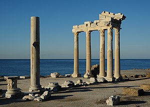
Temple of Apollo (Side)
Roman temple in Turkey
Distance: Approx. 5620 meters
Latitude and longitude: 36.76426,31.38664
The Temple of Apollo is a Roman temple built around 150 A.D. during the Pax Romana era in the ancient Carian town of Side, in southern Turkey on the Mediterranean Sea coast and dedicated to Apollo, the Greek and Roman god of music, harmony and light. The Temple of Apollo dates back to the time of Roman emperor Antoninus Pius (r. 138–161). Between 1984 and 1990, the five columns, which remained standing side by side over centuries, and the capitals were restored.
Weather in this IP's area
clear sky
29 Celsius
30 Celsius
29 Celsius
29 Celsius
1008 hPa
58 %
1008 hPa
1006 hPa
10000 meters
3.07 m/s
3.55 m/s
76 degree
05:55:55
20:05:18