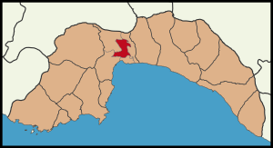
Country:
 Turkey
Region:
City:
Latitude and Longitude:
Time Zone:
Postal Code:
IP information under different IP Channel
ip-api
Country
Region
City
ASN
Time Zone
ISP
Blacklist
Proxy
Latitude
Longitude
Postal
Route
IPinfo
Country
Region
City
ASN
Time Zone
ISP
Blacklist
Proxy
Latitude
Longitude
Postal
Route
MaxMind
Country
Region
City
ASN
Time Zone
ISP
Blacklist
Proxy
Latitude
Longitude
Postal
Route
Luminati
Country
TRRegion
42
City
konya
ASN
Time Zone
Europe/Istanbul
ISP
TurkNet Iletisim Hizmetleri A.S.
Latitude
Longitude
Postal
db-ip
Country
Region
City
ASN
Time Zone
ISP
Blacklist
Proxy
Latitude
Longitude
Postal
Route
ipdata
Country
Region
City
ASN
Time Zone
ISP
Blacklist
Proxy
Latitude
Longitude
Postal
Route
Popular places and events near this IP address
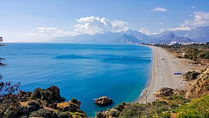
Antalya
City in Turkey
Distance: Approx. 2536 meters
Latitude and longitude: 36.8874,30.7075
Antalya is the fifth-most populous city in Turkey and the capital of Antalya Province. Recognized as the "capital of tourism" in Turkey and a pivotal part of the Turkish Riviera, Antalya sits on Anatolia's southwest coast, flanked by the Taurus Mountains. With over 2.6 million people in its metropolitan area, it is the largest city in Turkey's Mediterranean Region, situated along the Mediterranean Sea.

Hadrian's Gate
Ancient Roman memorial gate in Antalya, Turkey
Distance: Approx. 2793 meters
Latitude and longitude: 36.88523,30.70851
Hadrian's Gate (Turkish: Üçkapılar, meaning "The Three Gates") is a memorial gate located in Antalya, Turkey, which was built in the name of the Roman emperor Hadrian, who visited the city in 130 CE. It was later incorporated in the walls that surround the city and harbor, of which it is the only remaining entrance gate today. The gate was rediscovered by the Irish hydrographer Francis Beaufort in 1817, while commanding on HMS Fridericksteen.

Yivli Minaret Mosque
13th-century Seljuk-era mosque in Antalya, Turkey
Distance: Approx. 2542 meters
Latitude and longitude: 36.88638889,30.70444444
The Yivli Minaret Mosque (Turkish: Yivliminare Camii; lit. "Fluted Minaret" Mosque), also known as the Alaaddin Mosque (Turkish: Alaaddin Camii) or simply Grand Mosque (Turkish: Ulu Camii), in Antalya is a historical mosque built by the Anatolian Seljuk Sultan Kayqubad I. It is part of a külliye (complex of structures) which includes the Gıyaseddin Keyhüsrev Medrese, Seljuk and Dervish lodge, and the vaults of Zincirkıran and Nigar Hatun. The mosque is located in Kaleiçi (the old town centre) along Cumhuriyet Caddesi, next to Kalekapısı Meydanı.

Tekeli Mehmet Pasha Mosque
Ottoman mosque in Antalya, Turkey
Distance: Approx. 2583 meters
Latitude and longitude: 36.88638889,30.70583333
The Tekeli Mehmet Paşa Mosque (Turkish: Tekeli Mehmet Paşa Camii) is a mosque in the city of Antalya, Turkey. The mosque takes its name from Lala Mehmed Pasa. Built in the 17th century in the Kalekapisi district, the mosque is one of the most important Ottoman mosques in the city.

Murat Pasha Mosque, Antalya
Ottoman mosque in Antalya, Turkey
Distance: Approx. 1947 meters
Latitude and longitude: 36.8915,30.7025
The Murat Paşa Mosque (Turkish: Murat Paşa Camii) is an Ottoman mosque in the Muratpaşa borough of Antalya, Turkey.

Hidirlik Tower
Roman landmark tower in Antalya, Turkey
Distance: Approx. 3058 meters
Latitude and longitude: 36.88138889,30.70361111
Hıdırlık Tower (Turkish: Hıdırlık Kulesi) is a landmark tower of tawny stone in Antalya, Turkey, where Kaleiçi meets Karaalioğlu Park.

Antalya Stadium
Multi-purpose stadium in Antalya, Turkey
Distance: Approx. 3219 meters
Latitude and longitude: 36.88861111,30.66888889
The Antalya Stadium, officially branded as Corendon Airlines Park for sponsorship reasons, is a multi-purpose stadium in Antalya, Turkey. It is used mostly for football matches, hosting Turkish Süper Lig club Antalyaspor home matches. It has a capacity of nearly 32,537 (all seated) and is totally covered.
Dilek Sabancı Sport Hall
Indoor sporting arena in Antalya, Turkey
Distance: Approx. 3224 meters
Latitude and longitude: 36.8882,30.66928
Dilek Sabancı Sport Hall (Turkish: Dilek Sabancı Spor Salonu) was an indoor sporting arena located in Antalya, Turkey. Owned by the Sabancı Foundation, it was opened on November 3, 2001. The capacity of the arena was 2,500 spectators.
Antalya Sports Hall
Indoor sporting arena in Antalya, Turkey
Distance: Approx. 2939 meters
Latitude and longitude: 36.88869,30.67322
The Antalya Sports Hall is an indoor sporting arena located in Antalya, Turkey. Opened in 2016, the arena has a capacity of 10,000 spectators. It replaced the Dilek Sabancı Spor Salonu as the home of Turkish Basketball League clubs, Antalya Büyükşehir Belediyesi and Kepez Belediyespor.
Kepez, Antalya
District of Antalya, Turkey
Distance: Approx. 1450 meters
Latitude and longitude: 36.91666667,30.68333333
Kepez is a municipality and district of Antalya Province, Turkey. Its area is 292 km2, and its population is 608,675 (2022).
Antalya Centennial Archery Field
Archery field located in Antalya, Turkey
Distance: Approx. 3079 meters
Latitude and longitude: 36.88901,30.67057
Antalya Centennial Archery Field (Turkish: Antalya 100. Yıl Okçuluk Sahası) is an archery field located in Antalya, Turkey. Situated in Meltem neighborhood, the archery field on lawn has the dimensions 140 m × 175 m (459 ft × 574 ft), where 50 targets can be placed.
Doğu Garajı
Historical plot in Muratpaşa, Antalya
Distance: Approx. 2691 meters
Latitude and longitude: 36.88805556,30.7125
Doğu Garajı ("Eastern Bus depot") is a historical plot in Muratpaşa, Antalya, which was used to serve as depot of public buses in urban service and terminal for eastern districts of Antalya Province. A renovation project was proposed in the 1990s by Metropolitan Municipality of Antalya mayored by Hasan Subaşı, which was resulted in an interim "Festival Bazaar" in the 2000s. In the late 2000s, Mayor Menderes Türel broke ground for another renovation project.
Weather in this IP's area
clear sky
31 Celsius
30 Celsius
30 Celsius
31 Celsius
1010 hPa
34 %
1010 hPa
1003 hPa
10000 meters
5.66 m/s
320 degree
05:59:26
20:07:45