Country:
 Turkey
Region:
City:
Latitude and Longitude:
Time Zone:
Postal Code:
IP information under different IP Channel
ip-api
Country
Region
City
ASN
Time Zone
ISP
Blacklist
Proxy
Latitude
Longitude
Postal
Route
IPinfo
Country
Region
City
ASN
Time Zone
ISP
Blacklist
Proxy
Latitude
Longitude
Postal
Route
MaxMind
Country
Region
City
ASN
Time Zone
ISP
Blacklist
Proxy
Latitude
Longitude
Postal
Route
Luminati
Country
TRRegion
34
City
istanbul
ASN
Time Zone
Europe/Istanbul
ISP
TurkNet Iletisim Hizmetleri A.S.
Latitude
Longitude
Postal
db-ip
Country
Region
City
ASN
Time Zone
ISP
Blacklist
Proxy
Latitude
Longitude
Postal
Route
ipdata
Country
Region
City
ASN
Time Zone
ISP
Blacklist
Proxy
Latitude
Longitude
Postal
Route
Popular places and events near this IP address
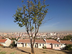
Batıkent, Yenimahalle
City in Turkey
Distance: Approx. 2049 meters
Latitude and longitude: 39.95,32.73333333
Batıkent (transl. West City) is a city near Ankara, Turkey. It is a suburban residential area located 16 kilometres (9.9 mi) west of the city, and Ankara's largest suburb. The population is approximately 200,000, mainly middle-class families; it is a popular residential area for students and government workers.
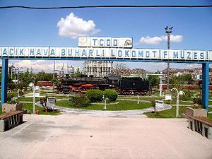
TCDD Open Air Steam Locomotive Museum
Distance: Approx. 4552 meters
Latitude and longitude: 39.94287484,32.77258302
The TCDD Open Air Steam Locomotive Museum (Turkish: TCDD Açık Hava Buharlı Lokomotif Müzesi) is a railroad museum in Ankara, Turkey, which focuses on the history of steam locomotives that operated on the Turkish State Railways. The museum was originally located in a park adjacent to Ankara Central Station, and when the property was needed for the station's enlargement project in 2014, the museum was moved to the current location near Wonderland Eurasia. The museum is owned and operated by the Turkish State Railways (TCDD), who also manages the Ankara Railway History Museum, as well as Atatürk's Car and Railway Art Museum.
Ankara Güvercinlik Army Air Base
Airport in Etimesgut, Ankara
Distance: Approx. 3809 meters
Latitude and longitude: 39.93495,32.740775
Ankara Güvercinlik Army Air Base, (Turkish: Ankara Güvercinlik Kara Hava Üssü) (ICAO: LTAB) is a military airport of the Turkish Army located in Güvercinlik of Etimesgut district, 10 km (6.2 mi) west of Ankara in central Turkey. The air base hosts General Staff controlled units, General Directorate of Mapping's aviation unit, Army Aviation School, 1st Army Aviation Regiment and Ankara Gendarmerie Aviation Group. The airport is open to general aviation for civil domestic flights with permission.

Etimesgut Air Base
Airport in Ankara, Turkey
Distance: Approx. 4145 meters
Latitude and longitude: 39.94983056,32.68862222
Etimesgut Air Base (IATA: ANK, ICAO: LTAD) (Turkish: Etimesgut Hava Üssü) is an airbase of the Turkish Air Force located 15 km (9.3 mi) west of Ankara, Turkey. It is owned by Turkish Air Force and jointly operated by the air force and the Turkish Aeronautical Association (Turkish: Türk Hava Kurumu) (THK). International Defense Industry, Aerospace and Maritime Fair (IDEF) and civil aviation airshows are being held at this airport.
Ankara 75th Anniversary Race Course
Distance: Approx. 4150 meters
Latitude and longitude: 39.96942,32.68218
Ankara 75th Anniversary Race Course (Turkish: Ankara 75. Yıl Hipodromu) is a horse racing track located at Batıkent neighborhood in Yenimahalle district of Ankara, Turkey. It is founded in 1998, which was the 75th anniversary of Turkish Republic's foundation.
Fomget Gençlik ve Spor
Turkish women's football club
Distance: Approx. 247 meters
Latitude and longitude: 39.96722222,32.73333333
Ankara Büyükşehir Belediyesi Fomget Gençlik ve Spor Kulübü, formerly Fomget Gençlik ve Spor, is a Turkish women's football sports club, based in the Mamak district of Ankara and sponsored by the Ankara Metropolitan Municipality. FOMGET is short for Folklor Müzik ve Gençlik Topluluğu (Folk Dance, Music and Youth Society), a youth and sports club best known for its folk dance group. Currently, they play in the Turkcell Women's Football Super League.

Batıkent (Ankara Metro)
Distance: Approx. 327 meters
Latitude and longitude: 39.9679,32.727
Batıkent is an underground rapid transit station of the Ankara Metro. It is located along Başkent Avenue at the intersection with 1777th Avenue. The station was originally opened as the western terminus of the M1 line on 29 December 1997.

Behiçbey railway station
Distance: Approx. 4426 meters
Latitude and longitude: 39.9314,32.7501
Behiçbey railway station (Turkish: Behiçbey istasyonu) is a railway station in Ankara, Turkey, currently being rebuilt. The station was a stop on the Ankara suburban from the 1930s to 2016 when it was closed and demolished shortly after, in order to rebuild and expand the railway. Construction of the new station began in 2017 and is expected to open on 12 April 2018.

Batımerkez
Distance: Approx. 1322 meters
Latitude and longitude: 39.96776,32.71532
Batı Merkez, is a surface rapid transit station of the Ankara Metro. Currently, only one line is in operation at this station. The station was opened on 12 February 2014, the same day the M3 line opened.

Mesa (Ankara Metro)
Distance: Approx. 2382 meters
Latitude and longitude: 39.971667,32.703222
Mesa, is an underground rapid transit station of the Ankara Metro. Currently, only one line is in operation at this station. The station was opened on 12 February 2014, the same day that the M3 line opened.
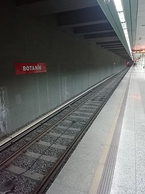
Botanik (Ankara Metro)
Distance: Approx. 3380 meters
Latitude and longitude: 39.980889,32.69475
Botanik, is an underground rapid transit station of the Ankara Metro. Currently, only one line is in operation at this station. The station was opened on 12 February 2014, the same day that the M3 line opened.

Macunköy (Ankara Metro)
Distance: Approx. 3097 meters
Latitude and longitude: 39.971833,32.766806
Macunköy, is a surface rapid transit station of the Ankara Metro. Currently, only one line is in operation at this station. The station was opened on 29 December 1997, the same day that the M1 line opened.
Weather in this IP's area
scattered clouds
25 Celsius
25 Celsius
25 Celsius
26 Celsius
1013 hPa
41 %
1013 hPa
919 hPa
10000 meters
8.75 m/s
350 degree
40 %
05:43:02
20:07:53