Country:
 Turkey
Region:
City:
Latitude and Longitude:
Time Zone:
Postal Code:
IP information under different IP Channel
ip-api
Country
Region
City
ASN
Time Zone
ISP
Blacklist
Proxy
Latitude
Longitude
Postal
Route
IPinfo
Country
Region
City
ASN
Time Zone
ISP
Blacklist
Proxy
Latitude
Longitude
Postal
Route
MaxMind
Country
Region
City
ASN
Time Zone
ISP
Blacklist
Proxy
Latitude
Longitude
Postal
Route
Luminati
Country
TRRegion
35
City
izmir
ASN
Time Zone
Europe/Istanbul
ISP
TurkNet Iletisim Hizmetleri A.S.
Latitude
Longitude
Postal
db-ip
Country
Region
City
ASN
Time Zone
ISP
Blacklist
Proxy
Latitude
Longitude
Postal
Route
ipdata
Country
Region
City
ASN
Time Zone
ISP
Blacklist
Proxy
Latitude
Longitude
Postal
Route
Popular places and events near this IP address

Karataş, Konak
Distance: Approx. 498 meters
Latitude and longitude: 38.4,27.1
Karataş (Ottoman Turkish: قره طاش) is a neighborhood of İzmir, Turkey, within the boundaries of the city's central metropolitan district of Konak. The neighborhood no longer has an official delimitation or status and exists as a notional zone (semt) that is admitted to stretch along the small cove of the same name (Karataş Cove (Koyu)) in the Gulf of İzmir. Its area roughly corresponds to the officially delimited quarter (mahalle) named Turgut Reis.

Göztepe, Konak
Neighbourhood in Konak, İzmir, Turkey
Distance: Approx. 1180 meters
Latitude and longitude: 38.39861111,27.09222222
Göztepe is a neighbourhood in the municipality and district of Konak, İzmir Province, Turkey. Its population is 15,897 (2022). It is situated on the southern shore of the Gulf of İzmir.

Asansör
Distance: Approx. 1315 meters
Latitude and longitude: 38.408798,27.117489
Asansör (Turkish for "elevator", derived from the French word ascenseur) is a historical building in İzmir's Karataş quarter, within the boundaries of the metropolitan district of Konak. It was built in 1907 as a work of public service by a wealthy Jewish banker and trader of that period, Nesim Levi Bayraklıoğlu, in order to ease passage from the narrow coastline of Karataş to the hillside, the elevator within the building serving to carry people and goods through the steep cliff between the two parts of the quarter. In time, the small street that led to the building also came to be known under the same name, Asansör Street (Asansör Sokağı).
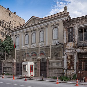
Bet Israel Synagogue (İzmir)
Synagogue in İzmir, Turkey
Distance: Approx. 1276 meters
Latitude and longitude: 38.40933,27.11645
The Bet Israel Synagogue is the largest synagogue in the city of İzmir, Turkey. It was built in 1907 and is in the Karataş quarter of the city. It's one of the two major synagogues in İzmir, the other being the recently built Shaar Hashamaym synagogue.

Üçyol (İzmir Metro)
Metro station in Turkey
Distance: Approx. 1385 meters
Latitude and longitude: 38.40561,27.1202
Üçyol is an underground station on the M1 Line of the İzmir Metro in Konak. Located beneath İnönü Avenue, just west of Üçyol Square, it is one of the ten original stations of the metro system, opened on 22 May 2000. From 2000 to the 2012, Üçyol was the western terminus of the line.

Avrasya Anı Evi
Turkish Museum
Distance: Approx. 1339 meters
Latitude and longitude: 38.40916667,27.1175
Avrasya Anı Evi ("Eurasian Memorial House") is a small museum in İzmir, Turkey.

Hatay (İzmir Metro)
Metro station
Distance: Approx. 256 meters
Latitude and longitude: 38.4016,27.1021
Hatay is an underground station on the M1 Line of the İzmir Metro in Hatay, Konak. Located under İnönü Avenue, it consists of two side platforms servicing two tracks. Connection to ESHOT bus service is available at street level.

Göztepe (İzmir Metro)
Distance: Approx. 1147 meters
Latitude and longitude: 38.396,27.0945
Göztepe is an underground station on the M1 Line of the İzmir Metro in Göztepe, Konak. Located under İnönü Avenue, it consists of two side platforms servicing two tracks. Connection to ESHOT bus service is available at street level.

Karantina (Tram İzmir)
Distance: Approx. 635 meters
Latitude and longitude: 38.408,27.1047
Karantina is a light rail station on the Konak Tram line in İzmir, Turkey. It is located within the 15 Temmuz Demkorasi Şehitleri Square in east Konak, above the Mustafa Kemal Coastal Boulevard as the throughway passes underneath the square. The station was originally named Mithatpaşa Lisesi from the historic Mithatpaşa high-school, located one block south of the station.
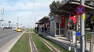
Köprü (Tram İzmir)
Distance: Approx. 688 meters
Latitude and longitude: 38.4058,27.0984
Köprü is a station on the Konak Tram line in İzmir, Turkey. It is located along the Mustafa Kemal Coastal Boulevard in west Konak. The station consists of two side platforms, one on each side of the boulevard.
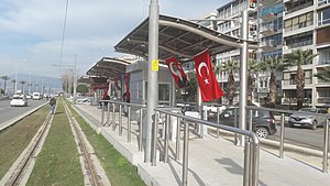
Sadıkbey (Tram İzmir)
Distance: Approx. 826 meters
Latitude and longitude: 38.4032,27.0955
Sadıkbey is a station on the Konak Tram line in İzmir, Turkey. Originally named Küçükyalı, it is located along the Mustafa Kemal Coastal Boulevard in west Konak. The station consists of two side platforms, one on each side of the boulevard.

Göztepe (Tram İzmir)
Distance: Approx. 826 meters
Latitude and longitude: 38.4032,27.0955
Göztepe is a station on the Konak Tram line in İzmir, Turkey. Originally named Vali Konağı, it is located along Mustafa Kemal Coastal Boulevard in west Konak. The station consists of two side platforms, one on each side of the boulevard.
Weather in this IP's area
few clouds
36 Celsius
35 Celsius
34 Celsius
36 Celsius
1011 hPa
19 %
1011 hPa
1005 hPa
10000 meters
10.29 m/s
30 degree
20 %
06:09:27
20:26:29