Country:
 Turkey
Region:
City:
Latitude and Longitude:
Time Zone:
Postal Code:
IP information under different IP Channel
ip-api
Country
Region
City
ASN
Time Zone
ISP
Blacklist
Proxy
Latitude
Longitude
Postal
Route
IPinfo
Country
Region
City
ASN
Time Zone
ISP
Blacklist
Proxy
Latitude
Longitude
Postal
Route
MaxMind
Country
Region
City
ASN
Time Zone
ISP
Blacklist
Proxy
Latitude
Longitude
Postal
Route
Luminati
Country
TRRegion
34
City
istanbul
ASN
Time Zone
Europe/Istanbul
ISP
TurkNet Iletisim Hizmetleri A.S.
Latitude
Longitude
Postal
db-ip
Country
Region
City
ASN
Time Zone
ISP
Blacklist
Proxy
Latitude
Longitude
Postal
Route
ipdata
Country
Region
City
ASN
Time Zone
ISP
Blacklist
Proxy
Latitude
Longitude
Postal
Route
Popular places and events near this IP address
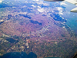
Gebze
District and municipality in Kocaeli, Turkey
Distance: Approx. 4749 meters
Latitude and longitude: 40.8,29.43333333
Gebze (Turkish pronunciation: [ˈɟebze]), formerly known as Libyssa, is a municipality and district of Kocaeli Province, Turkey. Its area is 418 km2, and its population is 407,019 (2022). It is situated 65 km (30 mi) southeast of Istanbul, on the Gulf of Izmit, the eastern arm of the Sea of Marmara.

Anadolu Medical Center
Hospital in Turkey
Distance: Approx. 4270 meters
Latitude and longitude: 40.81911,29.35351
Anadolu Medical Center (Turkish: Anadolu Sağlık Merkezi) is a hospital in Gebze, Kocaeli, Turkey. It is located in Çayırova on the highway D.100 at the Bayramoğlu exit, close to Sabiha Gökçen International Airport. Established by the Anadolu Foundation, the hospital was built on 186,000 m2 (2,000,000 sq ft) of land and opened on February 12, 2005.

Gebze railway station
Distance: Approx. 5696 meters
Latitude and longitude: 40.78388889,29.41083333
Gebze station (Turkish: Gebze garı) is a station on the Istanbul-Ankara railway in Gebze, Turkey. It is located between Plevne and Etem Paşa Avenues just southwest of Gebze's city center. It was the eastern terminus of the Haydarpaşa suburban commuter service until 2013 and in 2019 became the eastern terminus of the new Marmaray commuter rail line.

Çayırova, Kocaeli
District and municipality in Kocaeli, Turkey
Distance: Approx. 4079 meters
Latitude and longitude: 40.8,29.41666667
Çayırova is a municipality and district of Kocaeli Province, Turkey. Its area is 23 km2, and its population is 150,792 (2022). The district Çayırova was created in 2008 from part of the district of Gebze, along with the districts Darıca and Dilovası.

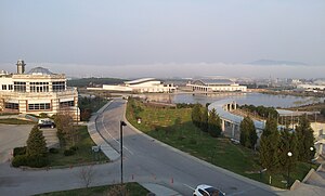
Gebze Technical University
Public university in Gebze, Kocaeli, Turkey
Distance: Approx. 4683 meters
Latitude and longitude: 40.80805556,29.35666667
Gebze Technical University (Turkish: Gebze Teknik Üniversitesi (GTÜ)), formerly known as Gebze Institute of Technology (GIT), is one of two institutes of technology founded in Turkey; The other one is İzmir Institute of Technology. It is a university for undergraduate and graduate studies and research activities located in a specifically selected area in Gebze, one of the most industrialized regions of the Marmara Region. Gebze Technical University is one of the universities that hold the title "research university" in Turkey, which "research university" title is given based on university's academic output by Council of Higher Education.
Sabancı University
Private university in İstanbul, Turkey
Distance: Approx. 6510 meters
Latitude and longitude: 40.89054722,29.37838611
Sabancı University (Turkish: Sabancı Üniversitesi), established in 1994, is a young foundation university located on a 1.26 million squaremeter campus which is about 40 km from Istanbul's city center. Its first students matriculated in 1999. The first academic session started on October 20, 1999 (1999-10-20T+2:00).

Fatih railway station
Distance: Approx. 4262 meters
Latitude and longitude: 40.8075,29.364
Gebze Teknik Üniversitesi – Fatih station (Turkish: Gebze Teknik Üniversitesi - Fatih istasyonu) is a station on the Marmaray commuter rail line in Gebze, Turkey. The station, along with Çayırova, is situated inside the Gebze Technical University campus. Commuter rail service resumed on 13 March 2019.

Çayırova railway station
Railway station in Çayırova, Turkey
Distance: Approx. 5161 meters
Latitude and longitude: 40.8105,29.3475
Çayırova railway station (Turkish: Çayırova istasyonu) is a railway station in Çayırova, Turkey. It is one of two stations (the other being Fatih) located within the campus of the Gebze Technical University. The station was originally built in 1954 by the Turkish State Railways and between 1969 and 2013, it was a stop along the Haydarpaşa suburban.
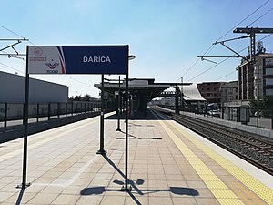
Darıca railway station
Distance: Approx. 4836 meters
Latitude and longitude: 40.7914,29.3918
Darıca station (Turkish: Darıca istasyonu) is a station on the Marmaray commuter rail in Darıca, Turkey. It is a new station that has been added to the railway with the Marmaray project. Construction of the station started in 2013 and was structurally completed in 2014, along with the other eight stations located between Pendik and Gebze.

Osmangazi railway station
Distance: Approx. 4265 meters
Latitude and longitude: 40.7992,29.38
Osmangazi station (Turkish: Osmangazi istasyonu) is a station on the Marmaray commuter rail line in Gebze, Turkey. It was previously a station on the Haydarpaşa suburban until 2013, when commuter rail service was suspended. The original station was opened in 1954 with two side platforms and demolished in 2013.
Dacibyza
Town of ancient Bithynia
Distance: Approx. 4775 meters
Latitude and longitude: 40.799732,29.433368
Dacibyza or Dakibyza (Ancient Greek: Δακίβυζα), or Dacibyze or Dakibyze (Δακιβύζη), was a town of ancient Bithynia located on the road from Libyssa to Chalcedon on the north coast of the Sinus Astacenus, an arm of the Propontis. Its site is located near Gebze, in Asiatic Turkey.
Potamoi (Bithynia)
Town of ancient Bithynia
Distance: Approx. 4355 meters
Latitude and longitude: 40.798384,29.379823
Potamoi (Ancient Greek: Ποταμοί) was a town of ancient Bithynia located on the road from Libyssa to Chalcedon on the north coast of the Sinus Astacenus, an arm of the Propontis. Its site is located east of Pendik, in Asiatic Turkey.
Weather in this IP's area
scattered clouds
26 Celsius
26 Celsius
26 Celsius
28 Celsius
1015 hPa
65 %
1015 hPa
1000 hPa
10000 meters
6.17 m/s
360 degree
40 %
05:54:07
20:23:27