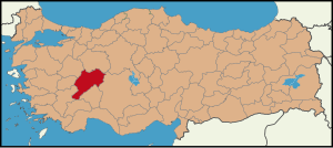
Country:
 Turkey
Region:
City:
Latitude and Longitude:
Time Zone:
Postal Code:
IP information under different IP Channel
ip-api
Country
Region
City
ASN
Time Zone
ISP
Blacklist
Proxy
Latitude
Longitude
Postal
Route
IPinfo
Country
Region
City
ASN
Time Zone
ISP
Blacklist
Proxy
Latitude
Longitude
Postal
Route
MaxMind
Country
Region
City
ASN
Time Zone
ISP
Blacklist
Proxy
Latitude
Longitude
Postal
Route
Luminati
Country
TRRegion
34
City
istanbul
ASN
Time Zone
Europe/Istanbul
ISP
TurkNet Iletisim Hizmetleri A.S.
Latitude
Longitude
Postal
db-ip
Country
Region
City
ASN
Time Zone
ISP
Blacklist
Proxy
Latitude
Longitude
Postal
Route
ipdata
Country
Region
City
ASN
Time Zone
ISP
Blacklist
Proxy
Latitude
Longitude
Postal
Route
Popular places and events near this IP address

Afyonkarahisar
Municipality in Turkey
Distance: Approx. 421 meters
Latitude and longitude: 38.75777778,30.53861111
Afyonkarahisar (Turkish pronunciation: [afˈjon.kaˌɾahisaɾ], Turkish: afyon 'poppy, opium', kara 'black', hisar 'fortress') is a city in western Turkey. It is the administrative centre of Afyonkarahisar Province and Afyonkarahisar District. Its population is 251,799 (2021).

Battle of Akroinon
Battle of the Arab-Byzantine Wars
Distance: Approx. 1150 meters
Latitude and longitude: 38.75,30.53333333
The Battle of Akroinon was fought at Akroinon or Akroinos (near modern Afyon) in Phrygia, on the western edge of the Anatolian plateau, in 740 between an Umayyad Arab army and the Byzantine forces. The Arabs had been conducting regular raids into Anatolia for the past century, and the 740 expedition was the largest in recent decades, consisting of three separate divisions. One division, 20,000 strong under Abdallah al-Battal and al-Malik ibn Shu'aib, was confronted at Akroinon by the Byzantines under the command of Emperor Leo III the Isaurian r. 717–741) and his son, the future Constantine V (r. 741–775).

Ali Çetinkaya railway station
Railway station in Turkey
Distance: Approx. 1119 meters
Latitude and longitude: 38.764,30.5523
Ali Çetinkaya railway station (Turkish: Ali Çetinkaya garı) is the main railway station in Afyonkarahisar, Turkey. The station is one of Afyon's two railway stations, the other being Afyonkarahisar Şehir railway station. Ali Çetinkaya station was built in 1895 by the Anatolian Railway as part of their main line between Istanbul and Konya.
2012 Afyonkarahisar arsenal explosion
2012 explosion of an arms depot in Afyonkarahisar, Turkey
Distance: Approx. 3222 meters
Latitude and longitude: 38.72790833,30.54113333
The 2012 Afyonkarahisar arsenal explosion occurred at 21:15 local time on 5 September 2012 in Afyonkarahisar, Turkey. According to Turkish Armed Forces, 25 servicemen died, four other soldiers and three civilians were injured by the accident. A fire at the locality followed the explosion.

Afyonkarahisar Castle
Castle in Afyonkarahisar, Turkey
Distance: Approx. 1048 meters
Latitude and longitude: 38.76526,30.53801
The Castle of Afyonkarahisar (Turkish: Afyonkarahisar Kalesi) is a historical fortification, which was built around 1350 BC and is located in Afyonkarahisar, Turkey. While Afyonkarahisar Castle (Literally: "Black Opium Castle" Fortress) refers specifically to the defensive fortification, Afyonkarahisar refers to the town containing the structure, and was renamed from Afyon to Afyonkarahisar in 2004.
Afyon Kocatepe Stadium
Distance: Approx. 6746 meters
Latitude and longitude: 38.79166667,30.47972222
Afyon Kocatepe Stadyumu, officially known as Zafer Stadyumu, is a stadium in Afyonkarahisar, Turkey. It opened on 21 July 2015 and it has a capacity of 15,000 spectators. It was the new home of Afyonkarahisarspor of the Turkish Regional Amateur League.
Altıgöz Bridge (Afyonkarahisar)
Bridge
Distance: Approx. 1508 meters
Latitude and longitude: 38.76969,30.54864
The Altıgöz Bridge (in Turkish: Altıgöz Köprüsü) is a stone bridge dating from the Sultanate of Rum period. The bridge is located in central western Anatolia, at Afyonkarahisar, close to the city's Çetinkaya railway station. Its Turkish name means "Six arch bridge".
Sülün
Municipality in Afyonkarahisar, Turkey
Distance: Approx. 6641 meters
Latitude and longitude: 38.7,30.56666667
Sülün is a town (belde) and municipality in the Afyonkarahisar District, Afyonkarahisar Province, Turkey. Its population is 2,939 (2021). It was the site of the ancient city of Prymnessos.

Grand Mosque of Afyonkarahisar
13th-century Seljuk-era mosque in Afyonkarahisar, Turkey
Distance: Approx. 1219 meters
Latitude and longitude: 38.755,30.52944444
The Afyon Grand Mosque (Turkish: Afyonkarahisar Ulu Camii) is a historical mosque in Afyonkarahisar in Afyonkarahisar province, Turkey.
Afyonkarahisar Motor Sports Center
Motor sports trqack in Afyonkarahisar, Turkey
Distance: Approx. 6265 meters
Latitude and longitude: 38.78577778,30.48141667
Afyonkarahisar Motor Sports Center (Turkish: Afyon Motor Sporları Merkezi) is a motor sports race track for motocross events in Afyonkarahisar, Turkey. Opened in 2016, the 1,725 m (5,659 ft)-long track has a hard pack type of soil. The race track was opened after a short construction time in 2016.
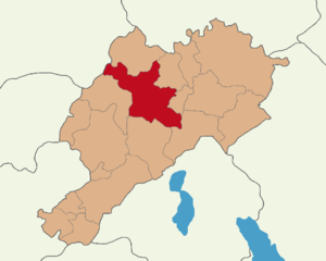
Afyonkarahisar District
District in Afyonkarahisar, Turkey
Distance: Approx. 1150 meters
Latitude and longitude: 38.75,30.53333333
Afyonkarahisar District (also: Merkez, meaning "central") is a district of Afyonkarahisar Province of Turkey. Its seat is the city Afyonkarahisar. Its area is 1,261 km2, and its population is 319,574 (2021).
Erkmen, Afyonkarahisar
Municipality in Afyonkarahisar, Turkey
Distance: Approx. 5240 meters
Latitude and longitude: 38.75972222,30.48305556
Erkmen is a town (belde) and municipality in the Afyonkarahisar District, Afyonkarahisar Province, Turkey. Its population is 7,293 (2021).
Weather in this IP's area
clear sky
26 Celsius
26 Celsius
26 Celsius
26 Celsius
1017 hPa
43 %
1017 hPa
906 hPa
10000 meters
7.93 m/s
8.92 m/s
95 degree
05:55:41
20:12:43