Country:
 Turkey
Region:
City:
Latitude and Longitude:
Time Zone:
Postal Code:
IP information under different IP Channel
ip-api
Country
Region
City
ASN
Time Zone
ISP
Blacklist
Proxy
Latitude
Longitude
Postal
Route
IPinfo
Country
Region
City
ASN
Time Zone
ISP
Blacklist
Proxy
Latitude
Longitude
Postal
Route
MaxMind
Country
Region
City
ASN
Time Zone
ISP
Blacklist
Proxy
Latitude
Longitude
Postal
Route
Luminati
Country
TRRegion
10
City
balikesir
ASN
Time Zone
Europe/Istanbul
ISP
TurkNet Iletisim Hizmetleri A.S.
Latitude
Longitude
Postal
db-ip
Country
Region
City
ASN
Time Zone
ISP
Blacklist
Proxy
Latitude
Longitude
Postal
Route
ipdata
Country
Region
City
ASN
Time Zone
ISP
Blacklist
Proxy
Latitude
Longitude
Postal
Route
Popular places and events near this IP address
Battle of Cyzicus
Land and sea battle between Athens and Sparta in 410 BC
Distance: Approx. 7978 meters
Latitude and longitude: 40.38,27.89
The Battle of Cyzicus (Greek: Kyzikos) took place in May or June 410 BC during the Peloponnesian War. During the battle, an Athenian fleet commanded by Alcibiades, Thrasybulus, and Theramenes routed and destroyed a Spartan fleet commanded by Mindarus. The victory allowed Athens to recover control over a number of cities in the Hellespont over the next year.

Battle of Cyzicus (193)
Battle between Septimius Severus and Pescennius Niger (193)
Distance: Approx. 7978 meters
Latitude and longitude: 40.38,27.89
The Battle of Cyzicus was fought in 193 between the forces of Septimius Severus and his rival for the empire, Pescennius Niger, who was defeated. The battle took place in the context of the Year of the Five Emperors, a tumultuous period in the Roman Empire when Emperor Pertinax was assassinated by the Praetorian Guards. The Praetorian Guards then held an auction for the throne, which was won by Didius Julianus, who became emperor.
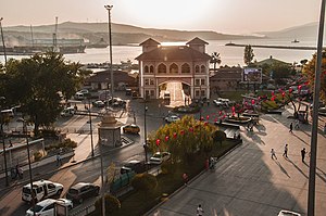
Bandırma
District and municipality in Balıkesir, Turkey
Distance: Approx. 886 meters
Latitude and longitude: 40.35,27.96666667
Bandırma (Turkish: [banˈdɯɾma]) is a municipality and district of Balıkesir Province, northwestern Turkey. Its area is 755 km2, and its population is 164,965 (2022). Bandırma is located in the south of the Marmara Sea, in the bay with the same name, and is an important port city.
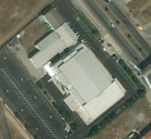
Kara Ali Acar Sport Hall
Indoor sports arena in Bandırma, Turkey
Distance: Approx. 1743 meters
Latitude and longitude: 40.3386,27.98688
Banvit Kara Ali Acar Sport Hall is an indoor arena located in the Bandırma town of Balıkesir Province, Turkey. The arena mostly hosts basketball games and is the home arena of the Bandırma Basketbol İhtisas and Bandırma Kırmızı basketball teams. It has a seating capacity for 3,000 spectators.
Bandırma Airport
Airport in Balıkesir, Turkey
Distance: Approx. 3832 meters
Latitude and longitude: 40.31777778,27.97722222
Bandırma Airport (IATA: BDM, ICAO: LTBG) is a military airbase and public airport located at Bandırma in the Balıkesir Province, Turkey. Bandırma Airport is home to the 6th Air Wing (Ana Jet Üs or AJÜ) of the 1st Air Force Command (Hava Kuvvet Komutanligi) of the Turkish Air Force (Türk Hava Kuvvetleri). Other wings of this command are located in Eskişehir (LTBI), Konya (LTAN), Ankara Akıncı (LTAE) and Balıkesir (LTBF).

Bandırma railway station
Railway station in Bandırma, Turkey
Distance: Approx. 925 meters
Latitude and longitude: 40.352,27.9658
Bandırma railway station is the main railway station in Bandırma, Turkey. It is located within the Port of Bandırma, adjacent to the Bandırma Ferry Terminal. It is the northern terminus of the 6th of September Express and the 17th of September Express, which operate daily to İzmir.
Bandırma Gulf
Gulf in Turkey
Distance: Approx. 3511 meters
Latitude and longitude: 40.38333333,27.98333333
Bandırma Gulf is a gulf on the Anatolian side of the Marmara Sea in Turkey. It is administratively a part of Bandırma district of Balıkesir Province. Belkıs Tombolo (connecting the Kapıdağ Peninsula to the Anatolia mainland) is to the west, the Kapıdağ Peninsula is to the north and the Marmara coast of Anatolia is to the south.

Bandırma Ferry Terminal
Distance: Approx. 783 meters
Latitude and longitude: 40.3528,27.9675
The Bandırma Ferry Terminal Turkish: Bandırma Ferribot Terminali) or Bandırma Pier (Turkish: Bandırma İskelesi) is a ferry terminal in Bandırma, Turkey, located within the Port of Bandırma on the Marmara Sea. It is used by İDO, which operates ferry service from Bandırma to Yenikapı in Istanbul. The terminal opened in 1998, when İDO began operating ferry service to Bandırma.
Kuşcenneti railway station
Railway station in Bandırma, Turkey
Distance: Approx. 1730 meters
Latitude and longitude: 40.3368,27.9794
Kuşcenneti railway station (Turkish: Kuşcenneti istasyonu) is a railway station in Bandırma, Turkey. The station is located in south Bandırma, near the Bandırma Airport. The station is used mostly as a yard for freight cars serving the nearby Etimaden Bohrium prossesing plant.

The Last Bullet Monument
Last bullets of Turkish War of Independence.
Distance: Approx. 5676 meters
Latitude and longitude: 40.35833333,27.91027778
Last Bullet Memorial, located at Bandırma district of Balıkesir represents last bullets of Turkish War of Independence.
Ömerli, Bandırma
Village in Turkey
Distance: Approx. 7458 meters
Latitude and longitude: 40.312,28.047
Ömerli is a neighbourhood in the municipality and district of Bandırma, Balıkesir province in Turkey. Its population is 5,057 (2022).
Bandırma 17 Eylül Stadium
Distance: Approx. 1715 meters
Latitude and longitude: 40.33805556,27.98472222
The Bandırma 17 Eylül Stadium, or simply 17 Eylül Stadium, is a multi-use stadium in Bandırma, Balıkesir, Turkey. It is currently used mostly for football matches and is the home ground of Bandırmaspor. The stadium holds 12,275 people and was built in 1995.
Weather in this IP's area
clear sky
27 Celsius
27 Celsius
27 Celsius
27 Celsius
1015 hPa
60 %
1015 hPa
1011 hPa
10000 meters
7.07 m/s
9.43 m/s
46 degree
06:01:04
20:27:53