Country:
 Guam
GuamRegion:
City:
Latitude and Longitude:
Time Zone:
Postal Code:
IP information under different IP Channel
ip-api
Country
Region
City
ASN
Time Zone
ISP
Blacklist
Proxy
Latitude
Longitude
Postal
Route
IPinfo
Country
Region
City
ASN
Time Zone
ISP
Blacklist
Proxy
Latitude
Longitude
Postal
Route
MaxMind
Country
Region
City
ASN
Time Zone
ISP
Blacklist
Proxy
Latitude
Longitude
Postal
Route
Luminati
Country
 SG
SGCity
singapore
ASN
Time Zone
Asia/Singapore
ISP
OneQode
Latitude
Longitude
Postal
db-ip
Country
Region
City
ASN
Time Zone
ISP
Blacklist
Proxy
Latitude
Longitude
Postal
Route
ipdata
Country
Region
City
ASN
Time Zone
ISP
Blacklist
Proxy
Latitude
Longitude
Postal
Route
Popular places and events near this IP address
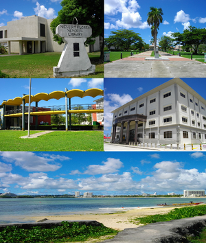
Hagåtña, Guam
Capital city of Guam
Distance: Approx. 428 meters
Latitude and longitude: 13.47916667,144.75
Hagåtña, formerly Agana or Agaña, is a coastal village and the capital of the United States territory of Guam. From the 18th through mid-20th century, it was Guam's population center, but today, it is the second smallest of the island's 19 villages in both area and population. However, it remains one of the island's major commercial districts in addition to being the seat of government.

Roman Catholic Archdiocese of Agaña
Roman Catholic archdiocese in Guam
Distance: Approx. 458 meters
Latitude and longitude: 13.47416667,144.75222222
The Archdiocese of Agaña (Latin: Archidiœcesis Aganiensis, Spanish: Arquidiócesis de Agaña) is a Latin Church ecclesiastical territory or diocese. It comprises the United States dependency of Guam. The prelate is an archbishop whose cathedral is the Dulce Nombre de Maria Cathedral-Basilica.

Legislature of Guam
Unicameral legislative branch of the US territory, Guam
Distance: Approx. 55 meters
Latitude and longitude: 13.47569444,144.74880556
The Legislature of Guam (Chamorro: Liheslaturan Guåhan) is the law-making body for the United States territory of Guam. The unicameral legislative branch consists of fifteen senators, each serving for a two-year term. All members of the legislature are elected at-large with the island under one whole district.
Guam High School (Guam)
High school in Agana Heights, Guam, United States
Distance: Approx. 463 meters
Latitude and longitude: 13.4740721,144.7443628
Guam High School (GHS or GMHS) is a U.S. military operated secondary school located at 401 Stitt Street in Agana Heights in the United States territory of Guam. The school, a part of the Department of Defense Education Activity, serves over 500 students grades 9 through 12. The school serves children of military personnel stationed in Guam.

Hagåtña River
River in Guam
Distance: Approx. 395 meters
Latitude and longitude: 13.4758333,144.7519444
The Hagåtña River is a river in the United States territory of Guam. Hagåtña, the capital of Guam, is located at the mouth of the river and associated wetlands form the eastern boundary of the city. The river mouth is depicted on both the Seal of Guam and Flag of Guam.

Plaza de España (Hagåtña)
United States historic place
Distance: Approx. 407 meters
Latitude and longitude: 13.47383333,144.75153333
The Plaza de España (Spain Square) located in central Hagåtña, the capital of the United States territory of Guam, was the location of the Governors Palace during the island's long period of Spanish occupation. Most of the palace was destroyed during the shelling of Hagåtña during the reconquest of Guam in World War II. There are three structures still standing including the three-arch gate to Almacen (Arsenal), the azotea or back porch, and the Chocolate House. The plaza was listed on the National Register of Historic Places in 1974.

Guam Museum
Museum focusing on the history of Guam
Distance: Approx. 372 meters
Latitude and longitude: 13.4752,144.7517
The Guam Museum, formally the Senator Antonio M. Palomo Guam Museum & Chamorro Educational Facility, is a museum focusing on the history of Guam, a U.S. territory in Micronesia. A permanent building to house the museum's collection opened in Hagåtña on November 4, 2016.

Agana Spanish Bridge
United States historic place
Distance: Approx. 82 meters
Latitude and longitude: 13.475,144.74805556
The Agana Spanish Bridge (Spanish: Puente Español de Agaña) is a stone arch bridge built in 1800 in Hagåtña, Guam (formerly known as Agana), during the administration of Spanish governor Manuel Muro. It is the only surviving Spanish bridge in Hagåtña, which is the capital of the United States territory of Guam. Also known as Sagon I Tolai Acho, it is located at the southwest corner of Aspenall St.

Guam Congress Building
United States historic place
Distance: Approx. 432 meters
Latitude and longitude: 13.475,144.75222222
The Guam Congress Building, also known as the Guam Legislature Building, is the seat of the Legislature of Guam and is located in Chalan Santo Papa in Hagåtña, Guam. It was built in 1949 by Pacific Island Buildings and of Brown & Root Pacific Bridge & Maxon. It has served as a capitol and as a courthouse building.

Guam Institute
United States historic place
Distance: Approx. 359 meters
Latitude and longitude: 13.47388889,144.74555556
The Guam Institute, located off in Guam Highway 1 in Hagåtña (formerly Agana or Agaña), Guam, was listed on the U.S. National Register of Historic Places in 1977; the listing included one contributing building. It was built in 1911. It has also been known as the Jose P. Lujan House.

Fort Santa Agueda
United States historic place
Distance: Approx. 239 meters
Latitude and longitude: 13.47361111,144.74777778
Fort Santa Agueda, on Guam Highway 7 in Hagåtña (formerly Agana), Guam, dates from about 1800, during the 1784-1802 administration of Spanish governor Manuel Moro. It was an uncovered fort with a manposteria (coral stone and lime mortar) parapet, rising about 10 feet (3.0 m) above a sloping hillside. It is listed on the U.S. National Register of Historic Places, as the only remaining fortification of the Spanish Era in Hagåtña.
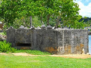
Agana-Hagatna Pillbox
United States historic place
Distance: Approx. 376 meters
Latitude and longitude: 13.47888889,144.74944444
The Agana-Hagåtña Pillbox is a former Japanese defensive fortification in Hagåtña, Guam. It is a six-sided reinforced concrete structure, located a short way above the high-tide line on the west side of the Paseo de Susana, a small peninsula jutting north from the village center. There is another wall providing cover for the entrance on the land side.
Weather in this IP's area
thunderstorm
27 Celsius
31 Celsius
27 Celsius
28 Celsius
1010 hPa
85 %
1010 hPa
1009 hPa
10000 meters
2.57 m/s
290 degree
40 %
06:04:51
18:49:55