Country:
 USA
USARegion:
City:
Latitude and Longitude:
Time Zone:
Postal Code:
IP information under different IP Channel
ip-api
Country
Region
City
ASN
Time Zone
ISP
Blacklist
Proxy
Latitude
Longitude
Postal
Route
IPinfo
Country
Region
City
ASN
Time Zone
ISP
Blacklist
Proxy
Latitude
Longitude
Postal
Route
MaxMind
Country
Region
City
ASN
Time Zone
ISP
Blacklist
Proxy
Latitude
Longitude
Postal
Route
Luminati
Country
USRegion
ks
City
kansascity
ASN
Time Zone
America/Chicago
ISP
UNITAS
Latitude
Longitude
Postal
db-ip
Country
Region
City
ASN
Time Zone
ISP
Blacklist
Proxy
Latitude
Longitude
Postal
Route
ipdata
Country
Region
City
ASN
Time Zone
ISP
Blacklist
Proxy
Latitude
Longitude
Postal
Route
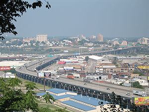
Popular places and events near this IP address

United States District Court for the District of Kansas
United States federal district court of Kansas
Distance: Approx. 507 meters
Latitude and longitude: 39.11701,-94.62218
The United States District Court for the District of Kansas (in case citations, D. Kan.) is the federal district court whose jurisdiction is the state of Kansas. The Court operates out of the Robert J. Dole United States Courthouse in Kansas City, Kansas, the Frank Carlson Federal Building in Topeka, and the United States Courthouse in Wichita. The District of Kansas was created in 1861, replacing the territorial court that preceded it, and President Abraham Lincoln appointed Archibald Williams as the Court's first judge.
Strawberry Hill (Kansas City, Kansas)
Kansas City neighborhood
Distance: Approx. 698 meters
Latitude and longitude: 39.1129,-94.6189
Strawberry Hill is a historic neighborhood in Kansas City, Kansas, United States. It is bordered by Minnesota Avenue to its north, by Interstate 70 to its east and south, and by 7th Street to its west.
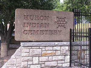
Huron Cemetery
Historic tribal cemetery in Kansas City, Kansas
Distance: Approx. 90 meters
Latitude and longitude: 39.11473333,-94.62602222
The Huron Indian Cemetery in Kansas City, Kansas, also known as Huron Park Cemetery, is now formally known as the Wyandot National Burying Ground. It was established c. 1843, soon after the Wyandot (called Huron by French explorers) had arrived following removal from Ohio. The tribe settled in the area for years, with many in 1855 accepting allotment of lands in Kansas in severalty.

Scottish Rite Temple (Kansas City, Kansas)
United States historic place
Distance: Approx. 69 meters
Latitude and longitude: 39.11388889,-94.62611111
The Scottish Rite Temple is located at 803 North 7th Street Trafficway in Kansas City, Kansas. It was designed by architect W. W. Rose. Construction began in 1908 and it was completed in 1909.

Memorial Hall (Kansas City, Kansas)
Auditorium in Kansas, United States
Distance: Approx. 217 meters
Latitude and longitude: 39.112352,-94.62761
Memorial Hall, or Soldiers and Sailors Memorial Building, is a multi-purpose auditorium located in Kansas City, Kansas. The 3,500-seat auditorium, which has a permanent stage, is used for public assemblies, concerts and sporting events. It was listed on the National Register of Historic Places in 1985.
Kansas City Athletic Club
Distance: Approx. 431 meters
Latitude and longitude: 39.114418,-94.631778
The Kansas City Athletic Club is an athletic club and gentlemen's club in downtown Kansas City, Missouri. Notable members have included President Harry S. Truman and others.
Cross Lines Tower
Distance: Approx. 257 meters
Latitude and longitude: 39.11648,-94.626322
Cross Lines Tower is a 15-story 175 foot high building that from 1951 to 1969 was the tallest building in Kansas City, Kansas. It is currently the tallest building in downtown and is the city's third tallest building – only a foot shorter than the other two. In its glory days in the 1950s and 1960s as a 250-room hotel at 1015 North 7th Street it was frequently used by visiting American Football League teams and was where singer Patsy Cline spent her last night before being killed in a plane crash while flying back to Nashville from Fairfax Airport.

7th Street Casino
Wyandotte Nation casino located in Kansas City, Kansas
Distance: Approx. 42 meters
Latitude and longitude: 39.11395,-94.62643
7th Street Casino is a Native American casino in Kansas City, Kansas owned and operated by the Wyandotte Nation.

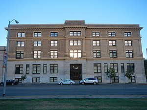
Wyandotte County Courthouse
United States historic place
Distance: Approx. 37 meters
Latitude and longitude: 39.11416667,-94.62722222
The Wyandotte County Courthouse, located at 710 N. 7th St. in Kansas City, Kansas, is a courthouse which was listed on the National Register of Historic Places in 2002. It was designed in Classical Revival style by architects Wight and Wight, and was built by contractor Godfrey Swensen.
Kansas City, Kansas City Hall and Fire Headquarters
United States historic place
Distance: Approx. 507 meters
Latitude and longitude: 39.11638889,-94.63194444
The Kansas City, Kansas City Hall and Fire Headquarters is a pair of buildings at 805 and 815 N. Sixth St. in Kansas City, Kansas. The buildings are also known as Old City Hall and Main Fire Station.

Kansas City, Kansas High School Gymnasium and Laboratory
United States historic place
Distance: Approx. 507 meters
Latitude and longitude: 39.11638889,-94.63194444
The Kansas City, Kansas High School Gymnasium and Laboratory, at 1017 N. 9th St. in Kansas City, Kansas, was built in 1923. It was listed on the National Register of Historic Places in 2012.
Kansas City, Kansas Public Library
Distance: Approx. 179 meters
Latitude and longitude: 39.115,-94.625
Kansas City, Kansas Public Library (KCKPL) is the public library system of Kansas City, Kansas, headquartered in the Main Library. The library serves Wyandotte County, Kansas.
Weather in this IP's area
clear sky
27 Celsius
30 Celsius
27 Celsius
29 Celsius
1010 hPa
74 %
1010 hPa
980 hPa
10000 meters
3.09 m/s
200 degree
06:15:48
20:33:57