Country:
 Italy
ItalyRegion:
City:
Latitude and Longitude:
Time Zone:
Postal Code:
IP information under different IP Channel
ip-api
Country
Region
City
ASN
Time Zone
ISP
Blacklist
Proxy
Latitude
Longitude
Postal
Route
IPinfo
Country
Region
City
ASN
Time Zone
ISP
Blacklist
Proxy
Latitude
Longitude
Postal
Route
MaxMind
Country
Region
City
ASN
Time Zone
ISP
Blacklist
Proxy
Latitude
Longitude
Postal
Route
Luminati
Country
ITASN
Time Zone
Europe/Rome
ISP
Wind Tre S.p.A.
Latitude
Longitude
Postal
db-ip
Country
Region
City
ASN
Time Zone
ISP
Blacklist
Proxy
Latitude
Longitude
Postal
Route
ipdata
Country
Region
City
ASN
Time Zone
ISP
Blacklist
Proxy
Latitude
Longitude
Postal
Route
Popular places and events near this IP address

Naples
City in southern Italy
Distance: Approx. 298 meters
Latitude and longitude: 40.83583333,14.24861111
Naples ( NAY-pəlz; Italian: Napoli [ˈnaːpoli] ; Neapolitan: Napule [ˈnɑːpulə]) is the regional capital of Campania and the third-largest city of Italy, after Rome and Milan, with a population of 909,048 within the city's administrative limits as of 2022. Its province-level municipality is the third-most populous metropolitan city in Italy with a population of 3,115,320 residents, and its metropolitan area stretches beyond the boundaries of the city wall for approximately 30 kilometres (20 miles). Founded by Greeks in the first millennium BC, Naples is one of the oldest continuously inhabited urban areas in the world.

Province of Naples
Former province of Campania, Italy
Distance: Approx. 11 meters
Latitude and longitude: 40.83333333,14.25
The province of Naples (Italian: provincia di Napoli; Neapolitan: pruvincia 'e Nàpule) was a province in the Campania region of Italy. In 2014/2015, the reform of local authorities (Law 142/1990 and Law 56/2014), replaced the province of Naples with the Metropolitan City of Naples.

1943 Naples post-office bombing
Distance: Approx. 45 meters
Latitude and longitude: 40.833,14.25
The 1943 Naples post office bombing occurred on October 7, 1943, after the U.S. Fifth Army had captured Naples (October 1) and reached the Volturno River (October 6). The Palazzo delle Poste, Naples, an imposing structure, completed in 1936 is located in the center of the city, was looted by Nazi troops during the occupation. After their retreat it became occupied by families who were made homeless by the bombing and destruction heaped on the city.

Battle of the Counts
Neopolitan naval engagement of 1287
Distance: Approx. 11 meters
Latitude and longitude: 40.83333333,14.25
The Battle of the Counts was a naval engagement during the War of the Sicilian Vespers. Fought on 23 June 1287 between the fleets of Aragon-Sicily and Angevin Naples, the battle was a major victory for the Aragonese fleet and its commander, Roger of Lauria.

Spaccanapoli (street)
Street in Naples, Italy
Distance: Approx. 11 meters
Latitude and longitude: 40.83333333,14.25
Spaccanapoli is the straight and narrow main street that traverses the old, historic center of the city of Naples, Italy. The name is a popular usage and means, literally, "Naples splitter". The name is derived from the fact that it is very long and from above it seems to divide that part of the city.

Via dei Tribunali, Naples
Street in the old historic center of Naples, Italy
Distance: Approx. 11 meters
Latitude and longitude: 40.83333333,14.25
Via dei Tribunali is a street in the old historic center of Naples, Italy. It was the main decumanus or Decumanus Maggiore — that is, the main east-west street—of the ancient Greek and then Roman city of Neapolis, paralleled to the south by the lower decumanus (Decumano Inferiore, now called Spaccanapoli) and to the north by the upper decumanus (Decumano Superiore) (now via Anticaglia and Via della Sapienza). The three decumani were (and still are) intersected by numerous north-south cross-streets called cardini, together forming the grid of the ancient city.

Capture of Neapolis
327 BC battle during the Second Samnite War
Distance: Approx. 14 meters
Latitude and longitude: 40.8333,14.25
The Capture of Neapolis took place during the Second Samnite War in 327 BC, when the Romans seized the city of Neapolis from the Samnites, an ancient Italic people who lived in Samnium. The city's fall is attributed to treachery committed by some of its citizens.

Borgo Santa Lucia
Distance: Approx. 131 meters
Latitude and longitude: 40.83222222,14.25
Borgo Santa Lucia, or simply Santa Lucia ("Saint Lucy [Borough]"), is a historical rione of Naples, Italy, facing the coast.
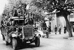
Four Days of Naples
Uprising against German forces in 1943
Distance: Approx. 14 meters
Latitude and longitude: 40.8333,14.25
The Four Days of Naples (Italian: Quattro giornate di Napoli) was an uprising in Naples, Italy, against Nazi German occupation forces from September 27 to September 30, 1943, immediately prior to the arrival of Allied forces in Naples on October 1 during World War II. The spontaneous uprising of Neapolitan and Italian Resistance against German occupying forces, despite their limited armament, and without proper organization or planning, successfully disrupted German plans to deport Neapolitans en masse, destroy the city, and prevent Allied forces from gaining a strategic foothold. The city was subsequently awarded the Gold Medal of Military Valor. The four days are celebrated annually and were the subject of the 1962 film The Four Days of Naples.

Santa Maria della Catena, Naples
Church building in Naples, Italy
Distance: Approx. 241 meters
Latitude and longitude: 40.83156,14.248585
Santa Maria della Catena or Santa Maria del Porto is a church in Borgo Santa Lucia of Naples, Italy. The church was founded in 1576 by the inhabitants of the quartiere, and dedicated to the Madonna della Catena, an important Marian cult in Naples and Sicily. The legend holds that in 1390 in Palermo, three innocent, yet condemned, prisoners had their execution delayed due to a downpour.
Metropolitan City of Naples
City in Campania, Italy
Distance: Approx. 14 meters
Latitude and longitude: 40.8333,14.25
The Metropolitan City of Naples (Italian: città metropolitana di Napoli) is a metropolitan city in the Campania region of Italy. Its capital is the city of Naples. The province was established on 1 January 2015 and contains 92 comuni (sg.: comune).
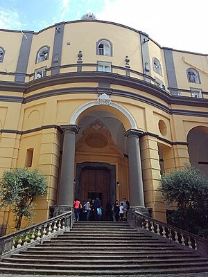
Santa Maria Egiziaca a Pizzofalcone
Distance: Approx. 282 meters
Latitude and longitude: 40.834126,14.246894
Santa Maria Egiziaca a Pizzofalcone is a Baroque-style, Roman Catholic, Basilica church on the street of the titular name in the hill of Pizzofalcone, in the historic center of Naples, region of Campania, Italy. The church layout was initially designed by Cosimo Fanzago.
Weather in this IP's area
clear sky
32 Celsius
35 Celsius
30 Celsius
34 Celsius
1015 hPa
50 %
1015 hPa
1013 hPa
10000 meters
4.12 m/s
300 degree
05:55:42
20:23:03