Country:
 USA
USARegion:
City:
Latitude and Longitude:
Time Zone:
Postal Code:
IP information under different IP Channel
ip-api
Country
Region
City
ASN
Time Zone
ISP
Blacklist
Proxy
Latitude
Longitude
Postal
Route
IPinfo
Country
Region
City
ASN
Time Zone
ISP
Blacklist
Proxy
Latitude
Longitude
Postal
Route
MaxMind
Country
Region
City
ASN
Time Zone
ISP
Blacklist
Proxy
Latitude
Longitude
Postal
Route
Luminati
Country
 AE
AERegion
du
City
dubai
ASN
Time Zone
Asia/Dubai
ISP
Emirates Integrated Telecommunications Company PJSC
Latitude
Longitude
Postal
db-ip
Country
Region
City
ASN
Time Zone
ISP
Blacklist
Proxy
Latitude
Longitude
Postal
Route
ipdata
Country
Region
City
ASN
Time Zone
ISP
Blacklist
Proxy
Latitude
Longitude
Postal
Route
Popular places and events near this IP address
East Whiteland Township, Pennsylvania
Township in Pennsylvania, United States
Distance: Approx. 1551 meters
Latitude and longitude: 40.03888889,-75.555
East Whiteland Township is a township in Chester County, Pennsylvania, United States. The population was 13,913 at the 2020 Census. Mailing addresses associated with East Whiteland include Malvern, Frazer, and a small area of Exton.

Malvern, Pennsylvania
Borough in Pennsylvania, United States
Distance: Approx. 2080 meters
Latitude and longitude: 40.03444444,-75.51444444
Malvern is a borough in Chester County, Pennsylvania, United States. Malvern is the terminus of the Main Line, a series of highly affluent Philadelphia suburbs located along the railroad tracks of the Pennsylvania Railroad. It is 19.4 miles (31.2 km) west of Philadelphia.
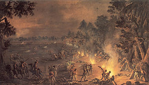
Battle of Paoli
United States historic place
Distance: Approx. 2061 meters
Latitude and longitude: 40.02972222,-75.51833333
The Battle of Paoli, also known as the Battle of Paoli Tavern or the Paoli Massacre, was a battle in the Philadelphia campaign of the American Revolutionary War fought on September 20, 1777, in the area surrounding present-day Malvern, Pennsylvania. Following the Continental Army's retreat in the Battle of Brandywine and the aborted Battle of the Clouds, George Washington left a force behind under the command of Brigadier General Anthony Wayne to monitor and resist the British as they prepared to attack and occupy the revolutionary capital of Philadelphia. On the evening of September 20, British forces under Major General Charles Grey led a surprise attack on Wayne's encampment near the Paoli Tavern in present-day Malvern, resulting in many American casualties.
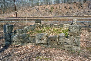
Duffy's Cut
Place in the United States
Distance: Approx. 608 meters
Latitude and longitude: 40.03722222,-75.5325
Duffy's Cut is the name given to a stretch of railroad tracks about 30 miles (48 km) west of Philadelphia, Pennsylvania, originally built for the Philadelphia and Columbia Railroad in the summer and fall of 1832. The line later became part of the Pennsylvania Railroad's Main Line. Railroad contractor Philip Duffy hired 57 Irish immigrants to lay this line through the area's densely wooded hills and ravines.
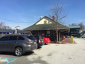
Malvern station (SEPTA)
Distance: Approx. 1926 meters
Latitude and longitude: 40.0363,-75.5155
Malvern station is a SEPTA Regional Rail and a former Amtrak station in Malvern, Pennsylvania. Located at West King Road and North Warren Avenue, it serves most Paoli/Thorndale Line trains. Until 1998, some Keystone Service trains stopped here as well.

Frazer, Pennsylvania
Unincorporated community in Pennsylvania, United States
Distance: Approx. 1916 meters
Latitude and longitude: 40.03222222,-75.55611111
Frazer is a census-designated place (CDP) in East Whiteland Township in Chester County, Pennsylvania, United States. It is located along US 30 between Exton and Malvern, and is the northern terminus for Pennsylvania Route 352. The former main line of the Pennsylvania Railroad, currently owned and operated by Amtrak and also used by SEPTA, passes through Frazer.

Villa Maria Academy (Malvern, Pennsylvania)
Private school in Malvern, , Pennsylvania, United States
Distance: Approx. 2549 meters
Latitude and longitude: 40.04027778,-75.50722222
Pennsylvania Association of Independent Schools (PAIS) Villa Maria Academy is an all-girls Catholic college-preparatory high school located in Malvern, Pennsylvania. The school was formed and carried out by the Sisters, Servants of the Immaculate Heart of Mary. Growth and development is key to this institution whether it be spiritually or intellectually.
Great Valley (Pennsylvania)
Valley through the center of Chester County, Pennsylvania
Distance: Approx. 1993 meters
Latitude and longitude: 40.0586,-75.53062
The Great Valley is a west-to-east valley through the center of Chester County, Pennsylvania, United States. It is also sometimes referred to as Chester Valley, and both names are in use throughout the region. The valley stretches from the Schuylkill River in Montgomery County in the east, southwesterly through Chester and Lancaster counties.
Penn State Great Valley School of Graduate Professional Studies
Distance: Approx. 1852 meters
Latitude and longitude: 40.05399,-75.52289
Penn State Great Valley School of Graduate Professional Studies is a special mission graduate school of Penn State University located in Malvern, Pennsylvania. Academic offerings include master's programs in engineering, information science, business, data analytics, finance, accounting, and software engineering. Continuing professional education courses and customized corporate training are also offered.

Frazer Diner
Original 1930s diner in Pennsylvania, U.S.
Distance: Approx. 71 meters
Latitude and longitude: 40.0419,-75.53761
The Frazer Diner, in Chester County, Pennsylvania, was built by the Jerry O'Mahony Diner Company and is now the only remaining example of an unaltered mid-1930s streamline modern O'Mahoney diner. Its original features include the monitor roof, half-moon windows, and porcelian-enameled base. The diner was split lengthwise and originally shipped to Paoli, Pennsylvania and operated as the Paoli Diner.

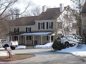
Spring Mill Complex
United States historic place
Distance: Approx. 2658 meters
Latitude and longitude: 40.0525,-75.56472222
The Spring Mill Complex, also known as the Gunkle Spring Mill, is a historic American gristmill complex constructed in 1793. The complex is located in East Whiteland Township, Chester County, Pennsylvania. It was listed on the National Register of Historic Places in 1978.
The Phelps School
Independent boarding school in Malvern, Chester County, Pennsylvania, United States
Distance: Approx. 2473 meters
Latitude and longitude: 40.0241,-75.5189
The Phelps School is an independent, all-boys boarding school in Malvern, Pennsylvania, United States.
Weather in this IP's area
clear sky
30 Celsius
33 Celsius
29 Celsius
32 Celsius
1013 hPa
62 %
1013 hPa
1000 hPa
10000 meters
1.79 m/s
3.58 m/s
360 degree
05:58:01
20:18:59