Country:
 USA
USARegion:
City:
Latitude and Longitude:
Time Zone:
Postal Code:
IP information under different IP Channel
ip-api
Country
Region
City
ASN
Time Zone
ISP
Blacklist
Proxy
Latitude
Longitude
Postal
Route
IPinfo
Country
Region
City
ASN
Time Zone
ISP
Blacklist
Proxy
Latitude
Longitude
Postal
Route
MaxMind
Country
Region
City
ASN
Time Zone
ISP
Blacklist
Proxy
Latitude
Longitude
Postal
Route
Luminati
Country
USRegion
nc
City
charlotte
ASN
Time Zone
America/New_York
ISP
Cato Networks Ltd
Latitude
Longitude
Postal
db-ip
Country
Region
City
ASN
Time Zone
ISP
Blacklist
Proxy
Latitude
Longitude
Postal
Route
ipdata
Country
Region
City
ASN
Time Zone
ISP
Blacklist
Proxy
Latitude
Longitude
Postal
Route
Popular places and events near this IP address

Charlotte, North Carolina
Largest city in North Carolina, United States
Distance: Approx. 14 meters
Latitude and longitude: 35.22722222,-80.84305556
Charlotte ( SHAR-lət) is the most populous city in the U.S. state of North Carolina and the county seat of Mecklenburg County. The population was 874,579 at the 2020 census, making Charlotte the 15th-most populous city in the United States, the seventh-most populous city in the South, and the second-most populous city in the Southeast behind Jacksonville, Florida. Charlotte is the cultural, economic, and transportation center of the Charlotte metropolitan area, whose estimated 2023 population of 2,805,115 ranked 22nd in the United States.
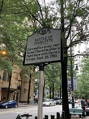
Battle of Charlotte
Distance: Approx. 27 meters
Latitude and longitude: 35.22694444,-80.84333333
The Battle of Charlotte was an American Revolutionary War battle fought in Charlotte, North Carolina on September 26, 1780. The battle took place at the Mecklenburg County Court House; which is now the site of the Bank of America tower at Trade and Tryon Streets in uptown Charlotte. An advance guard of General Charles Cornwallis' army rode into town and encountered a well-prepared Patriot militia under the command of William R. Davie in front of the court house.

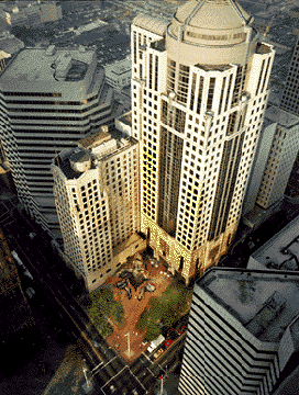
One South at The Plaza
Office / Retail in South Tryon Street
Distance: Approx. 56 meters
Latitude and longitude: 35.2266,-80.8432
One South at The Plaza (formerly the Bank of America Plaza) is a 503 feet (153 m), 40-story skyscraper in Charlotte, North Carolina. It is the 7th tallest in the city. It contains 891,000 square feet (82,777 m2) of rentable area of which 75,000 sq ft (7,000 m2) of retail space, and the rest office space.

121 West Trade
Skyscraper in Charlotte, North Carolina
Distance: Approx. 84 meters
Latitude and longitude: 35.2275,-80.84388889
121 West Trade (formerly known as the Interstate Tower) is an office high rise located at the Trade and Tryon, in Charlotte Center City, North Carolina, United States. The post modern building was designed by Kohn Pedersen Fox Associates and was completed in 1991. It also has 330,000 feet (101,000 m) of Class A office space.

One Independence Center
Office
Distance: Approx. 83 meters
Latitude and longitude: 35.226529,-80.843684
One Independence Center is a high-rise office building located in Uptown Charlotte, North Carolina. It was completed in 1983 and stands at a height of 301 ft (92 m) with 20 floors. It is the seventh largest building in Charlotte by leasable square feet with 565,694 square feet.

112 Tryon Plaza
Office in Charlotte, North Carolina
Distance: Approx. 65 meters
Latitude and longitude: 35.227,-80.8438
112 Tryon Plaza is a 280 feet (85 m) 22-story high-rise in Charlotte, North Carolina. It was the second tallest building in North Carolina when completed in 1927, and the tallest building in Charlotte for about 35 more years. It is currently the 21st tallest building in the city.
Independence Building
United States historic place
Distance: Approx. 45 meters
Latitude and longitude: 35.2275,-80.84305556
The Independence Building was a 186-foot (57 m) high-rise in Charlotte, Mecklenburg County, North Carolina, United States. It was built in 1909 by J.A. Jones Construction and imploded on September 27, 1981 to make way for 101 Independence Center. It originally had 12 floors but 2 more were added in 1928.
Timeline of Charlotte, North Carolina
Distance: Approx. 27 meters
Latitude and longitude: 35.226944,-80.843333
The following is a timeline of the history of Charlotte, North Carolina, United States.
Merchants and Farmers National Bank Building
United States historic place
Distance: Approx. 93 meters
Latitude and longitude: 35.22666667,-80.84222222
Merchants and Farmers National Bank Building was a historic bank building in Charlotte, Mecklenburg County, North Carolina. It was built in 1871–1872, a three-story, brick building with a stuccoed front and Italianate style cast iron trim manufactured by the Mecklenburg Iron Works. The building housed Independent Order of Odd Fellows lodges that met there from the 1870s through 1920.

Home Federal Building
United States historic place
Distance: Approx. 92 meters
Latitude and longitude: 35.22638889,-80.84361111
Home Federal Building is a historic bank building located at Charlotte, Mecklenburg County, North Carolina. It was built in 1967, and is a seven-story, reinforced-concrete, International Style building with an eight-story concrete-block service tower. Also on the property are a contributing fountain and pool (1967) and walkway bridge (1967).
Thomas Polk Park
Distance: Approx. 46 meters
Latitude and longitude: 35.22728,-80.84355
Thomas Polk Park is located in Charlotte, North Carolina, and comprises the west quadrant of Independence Square, at the intersection of Trade and Tryon Streets. Named for Thomas Polk, a founding father of Charlotte and was among the residents and officials of Mecklenburg County who drafted and adopted the Mecklenburg Resolves.

Tryon Street station
Streetcar station in Charlotte
Distance: Approx. 42 meters
Latitude and longitude: 35.22742,-80.84334
Tryon Street is a streetcar station in Charlotte, North Carolina. The at-grade dual side platforms on West Trade Street are a stop along the CityLynx Gold Line, serving Independence Square and the second largest financial hub of the United States.
Weather in this IP's area
broken clouds
27 Celsius
29 Celsius
26 Celsius
28 Celsius
1017 hPa
70 %
1017 hPa
992 hPa
10000 meters
4.12 m/s
110 degree
75 %
06:28:49
20:30:41