Country:
 France
Region:
City:
Latitude and Longitude:
Time Zone:
Postal Code:
IP information under different IP Channel
ip-api
Country
Region
City
ASN
Time Zone
ISP
Blacklist
Proxy
Latitude
Longitude
Postal
Route
IPinfo
Country
Region
City
ASN
Time Zone
ISP
Blacklist
Proxy
Latitude
Longitude
Postal
Route
MaxMind
Country
Region
City
ASN
Time Zone
ISP
Blacklist
Proxy
Latitude
Longitude
Postal
Route
Luminati
Country
FRRegion
ara
City
alixan
ASN
Time Zone
Europe/Paris
ISP
ADISTA SAS
Latitude
Longitude
Postal
db-ip
Country
Region
City
ASN
Time Zone
ISP
Blacklist
Proxy
Latitude
Longitude
Postal
Route
ipdata
Country
Region
City
ASN
Time Zone
ISP
Blacklist
Proxy
Latitude
Longitude
Postal
Route
Popular places and events near this IP address

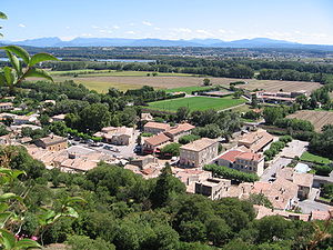
Montélimar
Commune in Auvergne-Rhône-Alpes, France
Distance: Approx. 34 meters
Latitude and longitude: 44.5581,4.7508
Montélimar (French pronunciation: [mɔ̃telimaʁ] ; Vivaro-Alpine: Montelaimar pronounced [muntelajˈma]; Latin: Acumum) is a town in the Drôme department in the Auvergne-Rhône-Alpes region in Southeastern France. It is the second-largest town in the department after Valence. In 2018, the commune had a population of 39,415; its urban area had a population of 57,372.

Château des Adhémar
Castle in Montélimar, Drôme, France
Distance: Approx. 283 meters
Latitude and longitude: 44.559098,4.754333
The Château des Adhémar is a castle, later converted to a Renaissance style château, in the French town of Montélimar in the Drôme département. It is located on a hill in the centre of the town.
Rochemaure
Commune in Auvergne-Rhône-Alpes, France
Distance: Approx. 4991 meters
Latitude and longitude: 44.5883,4.704
Rochemaure (French pronunciation: [ʁɔʃmoʁ]; Occitan: Ròchamaura) is a commune in the Ardèche department in Southern France. Many inhabitants of Rochemaure are in favour of the proposed road deviation in order to preserve the historic and cultural nature of the village. It is classified as a "village of character"; however, the area currently has a major departmental road running through it.

Le Teil
Commune in Auvergne-Rhône-Alpes, France
Distance: Approx. 5558 meters
Latitude and longitude: 44.5458,4.6831
Le Teil (French pronunciation: [lə.tɛj]) is a commune in the Ardèche department in southern France. The writer Romain Roussel (1898–1973) winner of the Prix Interallié in 1937 was born in Le Teil.

Ancône
Commune in Auvergne-Rhône-Alpes, France
Distance: Approx. 3226 meters
Latitude and longitude: 44.5825,4.7283
Ancône (French pronunciation: [ɑ̃kon]; Occitan: Ancona) is a commune in the Drôme department in southeastern France.

Montboucher-sur-Jabron
Commune in Auvergne-Rhône-Alpes, France
Distance: Approx. 4635 meters
Latitude and longitude: 44.5556,4.8092
Montboucher-sur-Jabron (French pronunciation: [mɔ̃buʃe syʁ ʒabʁɔ̃]; Occitan: Montboschier) is a commune in the Drôme department in southeastern France.

Saint-Marcel-lès-Sauzet
Commune in Auvergne-Rhône-Alpes, France
Distance: Approx. 5993 meters
Latitude and longitude: 44.596,4.805
Saint-Marcel-lès-Sauzet (French pronunciation: [sɛ̃ maʁsɛl lɛ sozɛ], literally Saint-Marcel near Sauzet; Occitan: Sant Marcèu de Sauset) is a commune in the Drôme department in southeastern France.

Savasse
Commune in Auvergne-Rhône-Alpes, France
Distance: Approx. 5010 meters
Latitude and longitude: 44.6,4.775
Savasse (French pronunciation: [savas]; Occitan: Savasse) is a commune in the Drôme department in southeastern France.

Manoir le Roure
Distance: Approx. 5197 meters
Latitude and longitude: 44.5119,4.7567
The Manoir le Roure is situated in the South of Montélimar, as part of the commune of Chateauneuf-du-Rhône, in Drôme provençale. The historical manor whose origins are dated back to the 14th century by the historian De Coston, is surrounded by a vast park with bassins and ornamental lakes.

Canton of Berg-Helvie
Canton of France
Distance: Approx. 5701 meters
Latitude and longitude: 44.55,4.68
The canton of Berg-Helvie is an administrative division of the Ardèche department, southern France. It was created at the French canton reorganisation which came into effect in March 2015. Its seat is in Le Teil.
Canton of Montélimar-1
Distance: Approx. 192 meters
Latitude and longitude: 44.56,4.75
The canton of Montélimar-1 is an administrative division of the Drôme department, southeastern France. Its borders were modified at the French canton reorganisation which came into effect in March 2015. Its seat is in Montélimar.
Canton of Montélimar-2
Distance: Approx. 938 meters
Latitude and longitude: 44.55,4.75
The canton of Montélimar-2 is an administrative division of the Drôme department, southeastern France. Its borders were modified at the French canton reorganisation which came into effect in March 2015. Its seat is in Montélimar.
Weather in this IP's area
few clouds
26 Celsius
26 Celsius
25 Celsius
28 Celsius
1019 hPa
73 %
1019 hPa
1009 hPa
10000 meters
3.49 m/s
7.45 m/s
17 degree
21 %
06:23:23
21:11:22