Country:
 France
Region:
City:
Latitude and Longitude:
Time Zone:
Postal Code:
IP information under different IP Channel
ip-api
Country
Region
City
ASN
Time Zone
ISP
Blacklist
Proxy
Latitude
Longitude
Postal
Route
IPinfo
Country
Region
City
ASN
Time Zone
ISP
Blacklist
Proxy
Latitude
Longitude
Postal
Route
MaxMind
Country
Region
City
ASN
Time Zone
ISP
Blacklist
Proxy
Latitude
Longitude
Postal
Route
Luminati
Country
FRRegion
ara
City
alixan
ASN
Time Zone
Europe/Paris
ISP
ADISTA SAS
Latitude
Longitude
Postal
db-ip
Country
Region
City
ASN
Time Zone
ISP
Blacklist
Proxy
Latitude
Longitude
Postal
Route
ipdata
Country
Region
City
ASN
Time Zone
ISP
Blacklist
Proxy
Latitude
Longitude
Postal
Route
Popular places and events near this IP address

Puygiron
Commune in Auvergne-Rhône-Alpes, France
Distance: Approx. 1932 meters
Latitude and longitude: 44.5425,4.8489
Puygiron (French pronunciation: [pɥiʒiʁɔ̃]; Occitan: Puegiron) is a commune in the Drôme department in southeastern France.
Portes-en-Valdaine
Commune in Auvergne-Rhône-Alpes, France
Distance: Approx. 4614 meters
Latitude and longitude: 44.5303,4.9125
Portes-en-Valdaine (French pronunciation: [pɔʁt ɑ̃ valdɛn]) is a commune in the Drôme department in southeastern France.
Bonlieu-sur-Roubion
Commune in Auvergne-Rhône-Alpes, France
Distance: Approx. 4671 meters
Latitude and longitude: 44.5953,4.8822
Bonlieu-sur-Roubion (French pronunciation: [bɔ̃ljø syʁ ʁubjɔ̃]) is a commune in the Drôme department in southeastern France.
La Bégude-de-Mazenc
Commune in Auvergne-Rhône-Alpes, France
Distance: Approx. 5710 meters
Latitude and longitude: 44.545,4.9364
La Bégude-de-Mazenc is a commune in the Drôme department in southeastern France.

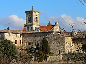
La Bâtie-Rolland
Commune in Auvergne-Rhône-Alpes, France
Distance: Approx. 0 meters
Latitude and longitude: 44.555,4.8658
La Bâtie-Rolland (French pronunciation: [la bati ʁɔlɑ̃]; Occitan: La Bastiá de Rotland) is a commune in the Drôme department in southeastern France.

Espeluche
Commune in Auvergne-Rhône-Alpes, France
Distance: Approx. 5389 meters
Latitude and longitude: 44.5169,4.8239
Espeluche (French pronunciation: [ɛspəlyʃ]; Occitan: Espelucha) is a commune in the Drôme department in the Auvergne-Rhône-Alpes region in southeastern France.

La Laupie
Commune in Auvergne-Rhône-Alpes, France
Distance: Approx. 6390 meters
Latitude and longitude: 44.6108,4.8469
La Laupie (French pronunciation: [la lopi]; Occitan: La Làupia) is a commune in the Drôme department in southeastern France.

Montboucher-sur-Jabron
Commune in Auvergne-Rhône-Alpes, France
Distance: Approx. 4490 meters
Latitude and longitude: 44.5556,4.8092
Montboucher-sur-Jabron (French pronunciation: [mɔ̃buʃe syʁ ʒabʁɔ̃]; Occitan: Montboschier) is a commune in the Drôme department in southeastern France.

Rochefort-en-Valdaine
Commune in Auvergne-Rhône-Alpes, France
Distance: Approx. 4313 meters
Latitude and longitude: 44.5164,4.8611
Rochefort-en-Valdaine is a commune in the Drôme department in southeastern France.

Saint-Gervais-sur-Roubion
Commune in Auvergne-Rhône-Alpes, France
Distance: Approx. 3703 meters
Latitude and longitude: 44.583,4.891
Saint-Gervais-sur-Roubion (French pronunciation: [sɛ̃ ʒɛʁvɛ syʁ ʁubjɔ̃]; Vivaro-Alpine: Sant Gervais de Robion) is a commune in the Drôme department in southeastern France.

La Touche, Drôme
Commune in Auvergne-Rhône-Alpes, France
Distance: Approx. 4760 meters
Latitude and longitude: 44.515,4.887
La Touche (French pronunciation: [la tuʃ]; Occitan: La Toscha) is a commune in the Drôme department in southeastern France.
Montélimar Agglomération
Communauté d'agglomération in Auvergne-Rhône-Alpes, France
Distance: Approx. 4072 meters
Latitude and longitude: 44.58333333,4.83333333
Montélimar Agglomération is the communauté d'agglomération, an intercommunal structure, centred on the city of Montélimar. It is located in the Drôme department, in the Auvergne-Rhône-Alpes region, southeastern France. Created in 2014, its seat is in Montélimar.
Weather in this IP's area
clear sky
28 Celsius
29 Celsius
27 Celsius
29 Celsius
1018 hPa
53 %
1018 hPa
999 hPa
10000 meters
3.94 m/s
7.1 m/s
355 degree
7 %
06:22:56
21:10:54