Country:
 USA
USARegion:
City:
Latitude and Longitude:
Time Zone:
Postal Code:
IP information under different IP Channel
ip-api
Country
Region
City
ASN
Time Zone
ISP
Blacklist
Proxy
Latitude
Longitude
Postal
Route
IPinfo
Country
Region
City
ASN
Time Zone
ISP
Blacklist
Proxy
Latitude
Longitude
Postal
Route
MaxMind
Country
Region
City
ASN
Time Zone
ISP
Blacklist
Proxy
Latitude
Longitude
Postal
Route
Luminati
Country
 SE
SERegion
n
City
halmstad
ASN
Time Zone
Europe/Stockholm
ISP
GlobalConnect AB
Latitude
Longitude
Postal
db-ip
Country
Region
City
ASN
Time Zone
ISP
Blacklist
Proxy
Latitude
Longitude
Postal
Route
ipdata
Country
Region
City
ASN
Time Zone
ISP
Blacklist
Proxy
Latitude
Longitude
Postal
Route
Popular places and events near this IP address

South Paris, Maine
CDP in Maine, United States
Distance: Approx. 2547 meters
Latitude and longitude: 44.22166667,-70.51472222
South Paris is a census-designated place (CDP) located within the town of Paris in Oxford County, Maine, United States. South Paris is included in the Lewiston-Auburn, Maine metropolitan New England city and town area.The population was 2,237 at the 2000 census. While the CDP refers only to the densely settled area in the southern part of the town of Paris, the entire town, outside of Paris Hill, is located within the South Paris ZIP code, resulting in many residents referring to the entire town as South Paris.

WPNO
Radio station in Maine, United States
Distance: Approx. 1553 meters
Latitude and longitude: 44.22118056,-70.52811667
WPNO (1450 AM) is a radio station licensed to serve South Paris, Maine. The station is owned by Bennett Radio Group. WPNO airs a conservative talk format simulcast with WEZR (780 AM) and W252DS (98.3 FM) in Rumford.
Oxford Hills Comprehensive High School
Public high school in Maine, United States
Distance: Approx. 1429 meters
Latitude and longitude: 44.2116,-70.5272
The Oxford Hills Comprehensive High School (OHCHS) is a public high school in South Paris, Maine, a census-designated place (CDP) located within the town of Paris in Oxford County, Maine, United States. Part of the Oxford Hills School District (MSAD 17), the school serves the towns of Paris, Oxford, Norway, West Paris, Waterford, Hebron, Harrison and Otisfield.
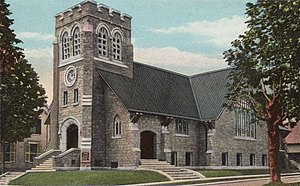
Deering Memorial United Methodist Church
Historic church in Maine, United States
Distance: Approx. 2562 meters
Latitude and longitude: 44.22305556,-70.51527778
Deering Memorial United Methodist Church is a historic church at 39 Main Street in South Paris, Maine. Completed in 1911 for a congregation established in 1815, it is the only known work in Maine of the Cleveland, Ohio partnership of Badgley and Nicklas, and one of Oxford County's finest late Gothic Revival churches. The building was listed on the National Register of Historic Places in 2008.
Nateva Music & Camping Festival
Music festival
Distance: Approx. 2595 meters
Latitude and longitude: 44.192518,-70.532186
Nateva Music & Camping Festival was a four-day, multi stage, limited capacity outdoor camping festival held July 1–4, 2010 at the 100+ acre Oxford Fairgrounds in Oxford, Maine. The festival featured headliners moe., The Flaming Lips, and Furthur. Lotus headlined "early bird" activities on Thursday, July 1.
Norway (CDP), Maine
CDP in Maine, United States
Distance: Approx. 578 meters
Latitude and longitude: 44.21166667,-70.53833333
Norway is a census-designated place (CDP) in the town of Norway in Oxford County, Maine, United States. The population was 2,623 at the 2000 census.

Norway, Maine
Town in Maine, United States
Distance: Approx. 578 meters
Latitude and longitude: 44.21166667,-70.53833333
Norway is a town in Oxford County, Maine, United States. Norway was included in the Lewiston-Auburn, Maine metropolitan New England city and town area. The population was 5,077 at the 2020 census.

Hersey Plow Company Building
United States historic place
Distance: Approx. 3165 meters
Latitude and longitude: 44.2225,-70.50694444
The Hersey Plow Company Building is a historic industrial building on Hill Street in South Paris, Maine. Believed to have been built about 1848, this brick structure is a rare small industrial building in the interior of Maine. It originally served as a warehouse and sales facility of the Hersey Plow Company, operated by various members of the Hersey family between 1835 and 1862.

McLaughlin House and Garden
Historic house in Maine, United States
Distance: Approx. 2245 meters
Latitude and longitude: 44.21888889,-70.5175
The McLaughlin House and Garden are a historic house museum and associated specimen garden at 97 Main Street in South Paris, Maine. The property includes a traditional New England connected farmstead with house, ell, and barn, all of which date to the mid-19th century, and a landscaped garden area developed beginning in the 1930s by Bernard McLaughlin that now houses more than 500 varieties of flowers. It is one of a small number of such specimen gardens in the state, and was listed on the National Register of Historic Places in 2000.

Norway Historic District
Historic district in Maine, United States
Distance: Approx. 325 meters
Latitude and longitude: 44.21333333,-70.54083333
The Norway Historic District encompasses most of the historic village center of Norway, Maine, and is reflective of the town's growth over 150 years. Although significant early-to-mid 19th century buildings survive in the village, it was significantly damaged by a major fire in 1894, resulting in the construction of a number of new brick and wood-frame buildings. The district, which is 44 acres (18 ha) in size, includes 64 historically significant residential, civic, social, and commercial buildings, and was listed on the National Register of Historic Places in 1988.

Paris Public Library
United States historic place
Distance: Approx. 2615 meters
Latitude and longitude: 44.22333333,-70.51472222
The Public Library of Paris, Maine, is located at 37 Market Square in the town of South Paris, Maine. The original portion of its building, a Colonial Revival brick structure built in 1926, was one of the last designs of the Portland architect John Calvin Stevens, and was listed on the National Register of Historic Places in 1989.

Elisha F. Stone House
Historic house in Maine, United States
Distance: Approx. 2660 meters
Latitude and longitude: 44.22472222,-70.515
The Elisha F. Stone House is a historic house at the corner of High and Gothic Streets in South Paris, Maine. Built in 1854, it is one of the finest Gothic Revival houses in Oxford County. The house was designed by Portland-based Henry Rowe, and built for Elisha F. Stone, a local merchant, tailor, and postmaster.
Weather in this IP's area
overcast clouds
20 Celsius
20 Celsius
18 Celsius
21 Celsius
1016 hPa
82 %
1016 hPa
1003 hPa
10000 meters
0.45 m/s
1.79 m/s
250 degree
100 %
05:26:54
20:10:10