Country:
 Netherlands
Region:
City:
Latitude and Longitude:
Time Zone:
Postal Code:
IP information under different IP Channel
ip-api
Country
Region
City
ASN
Time Zone
ISP
Blacklist
Proxy
Latitude
Longitude
Postal
Route
IPinfo
Country
Region
City
ASN
Time Zone
ISP
Blacklist
Proxy
Latitude
Longitude
Postal
Route
MaxMind
Country
Region
City
ASN
Time Zone
ISP
Blacklist
Proxy
Latitude
Longitude
Postal
Route
Luminati
Country
NLASN
Time Zone
Europe/Amsterdam
ISP
SURF B.V.
Latitude
Longitude
Postal
db-ip
Country
Region
City
ASN
Time Zone
ISP
Blacklist
Proxy
Latitude
Longitude
Postal
Route
ipdata
Country
Region
City
ASN
Time Zone
ISP
Blacklist
Proxy
Latitude
Longitude
Postal
Route
Popular places and events near this IP address

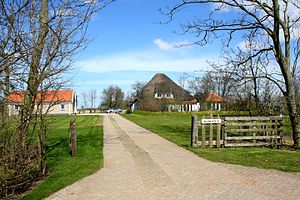
Texel
Municipality and island in North Holland, Netherlands
Distance: Approx. 506 meters
Latitude and longitude: 53.05,4.8
Texel (Dutch pronunciation: [ˈtɛsəl] ; Texels dialect: Tessel) is a municipality and an island with a population of 13,643 in North Holland, Netherlands. It is the largest and most populated island of the West Frisian Islands in the Wadden Sea. The island is situated north of Den Helder, northeast of Noorderhaaks, and southwest of Vlieland.

De Koog
Village in North Holland, Netherlands
Distance: Approx. 5367 meters
Latitude and longitude: 53.09777778,4.76277778
De Koog is a village in the Dutch province of North Holland. It is a part of the municipality of Texel, and lies about 17 km north of Den Helder. It is the chief centre of tourism on the island, surrounded with many hotels and campgrounds.
Zuid Haffel
Hamlet in North Holland, Netherlands
Distance: Approx. 2042 meters
Latitude and longitude: 53.0375,4.80972222
Zuid Haffel (South Haffel) is a polder and hamlet in the northwest of the Netherlands. It is located on the island of Texel, North Holland. Texel is also the municipality of the place.

Den Hoorn, North Holland
Village in North Holland, Netherlands
Distance: Approx. 4519 meters
Latitude and longitude: 53.02439167,4.751275
Den Hoorn is a village in the Dutch province of North Holland. It is a part of the municipality of Texel, and lies about 9 km north of Den Helder.

Den Burg
Town in North Holland, Netherlands
Distance: Approx. 506 meters
Latitude and longitude: 53.05,4.8
Den Burg is a town in the Dutch province of North Holland. It is a part of the municipality of Texel on the island of the same name, and lies about 12 km north of Den Helder.

Oudeschild
Village in North Holland, Netherlands
Distance: Approx. 3635 meters
Latitude and longitude: 53.04611111,4.84972222
Oudeschild is a village in the Dutch province of North Holland. It is a part of the island municipality of Texel, and lies about 12 km northeast of Den Helder. Oudeschild is the fishing harbour of the island.

Oosterend
Village in North Holland, Netherlands
Distance: Approx. 5672 meters
Latitude and longitude: 53.08333333,4.86666667
Oosterend is a village in the Dutch province of North Holland. It is a part of the municipality of Texel, and lies about 17 km northeast of Den Helder. Oosterend is the second largest village on the island.

De Waal
Village in North Holland, Netherlands
Distance: Approx. 1908 meters
Latitude and longitude: 53.06666667,4.81666667
De Waal is a village in the Dutch province of North Holland. It is a part of the municipality of Texel, and lies about 15 km north of Den Helder. The village was first mentioned in 1295 as "sancti Bonifacii in Waelkerken", and means "pond created after a dike breach".
Driehuizen, Texel
Hamlet in North Holland, Netherlands
Distance: Approx. 1636 meters
Latitude and longitude: 53.04666667,4.77611111
Driehuizen is a hamlet in the Dutch province of North Holland. It is located on the island of Texel, about 2 km southwest of the town of Den Burg. The name related to three fames ("drie huizen" in Dutch) were present at the site during the 16th century.
Bargen, Netherlands
Hamlet in North Holland, Netherlands
Distance: Approx. 4179 meters
Latitude and longitude: 53.08416667,4.83472222
Bargen is a hamlet in the northwest Netherlands, on the island and in the municipality of Texel, North Holland. It is located 4 km northeast of Den Burg. Bargen is not a statical entity, and the postal authorities have placed it under De Waal.
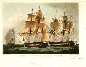
Action of 24 October 1798
Minor naval engagement of the French Revolutionary Wars
Distance: Approx. 5105 meters
Latitude and longitude: 53.099528,4.808667
The action of 24 October 1798 was a minor naval engagement of the French Revolutionary Wars, fought between a British Royal Navy frigate and two ships of the Batavian Navy. The Dutch ships were intercepted in the North Sea within hours of leaving port, 30 nautical miles (56 km) northwest of the Texel, by the British ship HMS Sirius. Both Dutch vessels were carrying large quantities of military supplies and French soldiers, reinforcements for the French and Irish forces participating in the Irish Rebellion of 1798.
Bij Jef
Restaurant in Texel, Netherlands
Distance: Approx. 4556 meters
Latitude and longitude: 53.02472222,4.74988056
Bij Jef (formerly: Culinaire Verwennerij Bij Jef) is a restaurant in Den Hoorn, Netherlands. It is a fine dining restaurant that was awarded one Michelin star for the period 2009–present. GaultMillau awarded the restaurant 16 out of 20 points.
Weather in this IP's area
few clouds
15 Celsius
15 Celsius
14 Celsius
16 Celsius
1026 hPa
88 %
1026 hPa
1026 hPa
10000 meters
1.03 m/s
210 degree
21 %
05:53:57
21:40:24