Country:
 Canada
Region:
City:
Latitude and Longitude:
Time Zone:
Postal Code:
IP information under different IP Channel
ip-api
Country
Region
City
ASN
Time Zone
ISP
Blacklist
Proxy
Latitude
Longitude
Postal
Route
IPinfo
Country
Region
City
ASN
Time Zone
ISP
Blacklist
Proxy
Latitude
Longitude
Postal
Route
MaxMind
Country
Region
City
ASN
Time Zone
ISP
Blacklist
Proxy
Latitude
Longitude
Postal
Route
Luminati
Country
CARegion
on
City
vaughan
ASN
Time Zone
America/Toronto
ISP
HYDROONETELECOM
Latitude
Longitude
Postal
db-ip
Country
Region
City
ASN
Time Zone
ISP
Blacklist
Proxy
Latitude
Longitude
Postal
Route
ipdata
Country
Region
City
ASN
Time Zone
ISP
Blacklist
Proxy
Latitude
Longitude
Postal
Route
Popular places and events near this IP address

York, Upper Canada
Unincorporated municipality in Home District, Upper Canada
Distance: Approx. 130 meters
Latitude and longitude: 43.6525,-79.38166667
York was a town and the second capital of the colony of Upper Canada. It is the predecessor to the old city of Toronto (1834–1998). It was established in 1793 by Lieutenant-Governor John Graves Simcoe as a "temporary" location for the capital of Upper Canada, while he made plans to build a capital near today's London, Ontario.
Battle of York
War of 1812 battle
Distance: Approx. 130 meters
Latitude and longitude: 43.6525,-79.38166667
The Battle of York was a War of 1812 battle fought in York, Upper Canada (today's Toronto, Ontario, Canada) on April 27, 1813. An American force, supported by a naval flotilla, landed on the western lakeshore and captured the provincial capital after defeating an outnumbered force of regulars, militia and Ojibwe natives under the command of Major General Roger Hale Sheaffe, the Lieutenant Governor of Upper Canada. After Sheaffe's forces were defeated, he ordered his surviving regulars to withdraw to Kingston, abandoning the militia and civilians.

Toronto City Hall
Canadian city hall, opened 1965
Distance: Approx. 96 meters
Latitude and longitude: 43.65333333,-79.38388889
The Toronto City Hall, or New City Hall, is the seat of the municipal government of Toronto, Ontario, Canada, and one of the city's most distinctive landmarks. Designed by Viljo Revell and engineered by Hannskarl Bandel, the building opened in 1965. The building is located adjacent to Nathan Phillips Square, a public square at the northwest intersection of Bay Street and Queen Street, that was designed and officially opened alongside Toronto City Hall.

Old City Hall (Toronto)
Civic building, court house in Ontario, Canada
Distance: Approx. 130 meters
Latitude and longitude: 43.6525,-79.38166667
The Old City Hall is a Romanesque-style civic building and former court house in Toronto, Ontario, Canada. It was the home of the Toronto City Council from 1899 to 1966 and a provincial court house until 2023, and remains one of the city's most prominent structures. The building is located at the corner of Queen and Bay Streets, across Bay Street from Nathan Phillips Square and the present City Hall in Downtown Toronto.
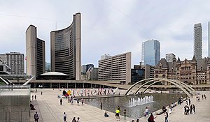
Nathan Phillips Square
Public square in Downtown Toronto
Distance: Approx. 124 meters
Latitude and longitude: 43.6525,-79.38361111
Nathan Phillips Square is an urban plaza in Toronto, Ontario, Canada. It forms the forecourt to Toronto City Hall, or New City Hall, at the intersection of Queen Street West and Bay Street, and is named after Nathan Phillips, mayor of Toronto from 1955 to 1962. The square was designed by the City Hall's architect Viljo Revell and landscape architect Richard Strong.

Eaton's Annex
Distance: Approx. 59 meters
Latitude and longitude: 43.6537,-79.3821
Eaton's Annex was a 10-storey building containing both retail and office space in Downtown Toronto, Ontario, Canada. It opened in January 1913 and was located at the northwest corner of Albert Street and James Street, west of Eaton's Main Store and north of Toronto's (now former) City Hall.

Downtown Toronto
Central business district in Toronto, Ontario, Canada
Distance: Approx. 121 meters
Latitude and longitude: 43.65250278,-79.38355833
Downtown Toronto is the main central business district of Toronto, Ontario, Canada. Located entirely within the district of Old Toronto, it is approximately 16.6 square kilometres in area, bounded by Bloor Street to the northeast and Dupont Street to the northwest, Lake Ontario to the south, the Don Valley to the east, and Bathurst Street to the west. It is also the home of the municipal government of Toronto and the Government of Ontario.
Ontario Ombudsman
Distance: Approx. 31 meters
Latitude and longitude: 43.6534366,-79.3823149
The Office of the Ombudsman of Ontario is an independent office of the Legislative Assembly of Ontario in the Canadian province of Ontario.

Bell Trinity Square
Office complex in Toronto
Distance: Approx. 39 meters
Latitude and longitude: 43.65333333,-79.38222222
Bell Trinity Square is an office complex occupying part of the former site of the historic Eaton's Annex in downtown Toronto, Ontario, Canada. The name is a combination of: the name of original and now former occupant Bell Canada; the location of the site south of the Church of the Holy Trinity; and Trinity Square. Built in from 1980 to 1983 and designed by architect John B. Parkin, the post modern complex consists of 15 floor and 10 floor towers connected by a glass atrium.

Toronto Sign
Illuminated sign in Ontario, Canada
Distance: Approx. 124 meters
Latitude and longitude: 43.6525,-79.38361111
The Toronto Sign is an illuminated three-dimensional sign in Nathan Phillips Square in Toronto, Ontario, Canada, that spells the city's name. It is 3 metres (9.8 ft) tall and 22 metres (72 ft) long (prior to the addition of the maple leaf and the medicine wheel), lit by LED lights that can create an estimated 228 million colour combinations.

Shea's Hippodrome
Distance: Approx. 88 meters
Latitude and longitude: 43.652613,-79.382709
Shea's Hippodrome was a historic film and play theatre in Toronto, Ontario, Canada. The Hippodrome was located in downtown Toronto, at the southwest corner of Albert and Bay streets (now Nathan Phillips Square). At its opening in 1914, it was the largest movie palace in Canada, and one of the largest vaudeville theatres in the world.

Three Way Piece No.2: Archer
Sculpture by Henry Moore
Distance: Approx. 122 meters
Latitude and longitude: 43.65283,-79.384
Three Way Piece No.2: Archer is a large sculpture by the British artist Henry Moore. Two casts exist: cast 1 in Toronto, cast 2 is owned by the National Gallery, Berlin. The work is 340 cm long and 325 cm high.
Weather in this IP's area
clear sky
17 Celsius
17 Celsius
15 Celsius
18 Celsius
1022 hPa
87 %
1022 hPa
1011 hPa
10000 meters
2.57 m/s
230 degree
06:01:45
20:46:04