Country:
 Canada
Region:
City:
Latitude and Longitude:
Time Zone:
Postal Code:
IP information under different IP Channel
ip-api
Country
Region
City
ASN
Time Zone
ISP
Blacklist
Proxy
Latitude
Longitude
Postal
Route
IPinfo
Country
Region
City
ASN
Time Zone
ISP
Blacklist
Proxy
Latitude
Longitude
Postal
Route
MaxMind
Country
Region
City
ASN
Time Zone
ISP
Blacklist
Proxy
Latitude
Longitude
Postal
Route
Luminati
Country
CARegion
bc
City
kamloops
ASN
Time Zone
America/Vancouver
ISP
Equinix (EMEA) Acquisition Enterprises B.V.
Latitude
Longitude
Postal
db-ip
Country
Region
City
ASN
Time Zone
ISP
Blacklist
Proxy
Latitude
Longitude
Postal
Route
ipdata
Country
Region
City
ASN
Time Zone
ISP
Blacklist
Proxy
Latitude
Longitude
Postal
Route
Popular places and events near this IP address

Kamloops
City in British Columbia, Canada
Distance: Approx. 1778 meters
Latitude and longitude: 50.67583333,-120.33944444
Kamloops ( KAM-loops) is a city in south-central British Columbia, Canada, at the confluence of the North and South Thompson Rivers, which join to become the Thompson River in Kamloops, and east of Kamloops Lake. It is located in the Thompson-Nicola Regional District, whose district offices are based here. The surrounding region is sometimes referred to as the Thompson Country.
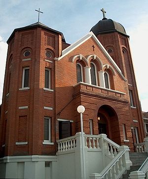
Sacred Heart Cathedral (Kamloops)
Church in Kamloops, Canada
Distance: Approx. 1271 meters
Latitude and longitude: 50.6721,-120.3347
Sacred Heart Cathedral is a Romanesque-style church that serves as the cathedral of the Roman Catholic Diocese of Kamloops. It is located in the downtown area of Kamloops at the intersection of Nicola Street and 3rd Avenue. The construction of the cathedral began in 1921, a few blocks from the site of an earlier church by the same name that had burned down two years earlier.

Sandman Centre
Multi-use indoor arena in Kamloops, British Columbia
Distance: Approx. 1649 meters
Latitude and longitude: 50.67833333,-120.33305556
The Sandman Centre (formerly known as Riverside Coliseum and Interior Savings Centre) is a 5,464-seat multi-purpose arena in Kamloops, British Columbia, Canada. It is home to the Kamloops Blazers ice hockey team. The arena is owned by the City of Kamloops.
South Kamloops Secondary School
High school in Kamloops, British Columbia, Canada
Distance: Approx. 108 meters
Latitude and longitude: 50.66627,-120.32048
École Secondaire South Kamloops Secondary School (SKSS), Home of the Titans, is a grade 8-12 school in Kamloops, British Columbia, Canada. It was formed in 1904 under the name Kamloops High School, and moved to its present campus in 1952. It gained the name South Kamloops Secondary School in 2003 through the merger of John Peterson Secondary School and Kamloops Secondary School, two secondary schools located adjacently on the same block.

Kamloops Heritage Railway
Distance: Approx. 1554 meters
Latitude and longitude: 50.6787,-120.3297
The Kamloops Heritage Railway is a heritage railway in Kamloops, British Columbia. The railway operates throughout the year running trains within Kamloops. The train is pulled by restored steam locomotive Canadian National Railway 2141, the "Spirit of Kamloops".
Kamloops Memorial Arena
Distance: Approx. 1130 meters
Latitude and longitude: 50.6763,-120.3232
The Kamloops Memorial Arena is an ice hockey arena built in 1948 in Kamloops, British Columbia. It hosted the Western Hockey League teams including the Kamloops Chiefs, Kamloops Junior Oilers and, most notably, the Kamloops Blazers. It was replaced in 1992 by the new Riverside Coliseum (now known as the Sandman Centre).

St. Paul's Cathedral (Kamloops)
Distance: Approx. 1163 meters
Latitude and longitude: 50.67248,-120.33251
St Paul's Cathedral, Kamloops, is the Cathedral church for the Territory of the People, Anglican Church of Canada. The Territory of the People (the Territory) was formerly known as the Diocese of Cariboo, which was dissolved because of its inability to meet tort judgments against it in respect of abuse in Indian residential schools. After dissolution of the Diocese of the Cariboo the Territory was temporarily known as The Anglican Parishes of the Central Interior.
Kamloops Museum and Archives
Distance: Approx. 1530 meters
Latitude and longitude: 50.6747,-120.3364
The Kamloops Museum and Archives is a museum and archives located in the city of Kamloops, British Columbia, Canada. Located at 207 Seymour Street in downtown Kamloops, at the corner of 2nd Avenue. In addition to historical exhibits and educational programmes, the facility also is home to the city's archives, including a special collection, the Mary Balf Archives, focused around the works of Mary Balf, a prolific local historian, but including a wide array of documents from the early fur trade journals onwards.

Kamloops station
Railway station in Kamloops, Canada
Distance: Approx. 1562 meters
Latitude and longitude: 50.67877778,-120.32972222
Kamloops station is a railway station in Kamloops, British Columbia, Canada. It serves as the overnight stopover point for the Rocky Mountaineer train service to Jasper and Banff from Vancouver. The station was originally built for Canadian National Railway The station was declared a Heritage Railway Station in 1992.
Yellowhead Bridge (Kamloops)
Distance: Approx. 1662 meters
Latitude and longitude: 50.675556,-120.300278
The Yellowhead Bridge or the East Kamloops Bridge is a road bridge in Kamloops, British Columbia. It carries Highway 5 over the South Thompson River. It was completed in December of 1968 and has a length of 179.2 metres, not including a preceding railway overhead on the south side of the river.
Western Canada Theatre
Distance: Approx. 53 meters
Latitude and longitude: 50.66627,-120.31966
Western Canada Theatre is a professional theatre company located in Kamloops, British Columbia, Canada. It was founded in 1975 by Tom Kerr under the name Western Canada Youth Theatre. It currently offers seven live performances throughout the season; five mainstage and two alternative/experimental productions.
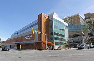
Royal Inland Hospital
Hospital in British Columbia, Canada
Distance: Approx. 970 meters
Latitude and longitude: 50.66888889,-120.33222222
Royal Inland Hospital is a medical facility located in Kamloops, British Columbia serving a catchment area of 225,000 km2.
Weather in this IP's area
smoke
25 Celsius
24 Celsius
25 Celsius
27 Celsius
1006 hPa
38 %
1006 hPa
960 hPa
10000 meters
2.06 m/s
250 degree
40 %
05:23:19
20:51:58