Country:
 USA
USARegion:
City:
Latitude and Longitude:
Time Zone:
Postal Code:
IP information under different IP Channel
ip-api
Country
Region
City
ASN
Time Zone
ISP
Blacklist
Proxy
Latitude
Longitude
Postal
Route
IPinfo
Country
Region
City
ASN
Time Zone
ISP
Blacklist
Proxy
Latitude
Longitude
Postal
Route
MaxMind
Country
Region
City
ASN
Time Zone
ISP
Blacklist
Proxy
Latitude
Longitude
Postal
Route
Luminati
Country
USRegion
fl
City
pensacola
ASN
Time Zone
America/Chicago
ISP
UNITI-FIBER
Latitude
Longitude
Postal
db-ip
Country
Region
City
ASN
Time Zone
ISP
Blacklist
Proxy
Latitude
Longitude
Postal
Route
ipdata
Country
Region
City
ASN
Time Zone
ISP
Blacklist
Proxy
Latitude
Longitude
Postal
Route
Popular places and events near this IP address
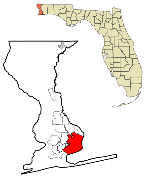
Pensacola, Florida
City in Florida, United States
Distance: Approx. 31 meters
Latitude and longitude: 30.42138889,-87.21722222
Pensacola ( PEN-sə-KOH-lə) is the westernmost city in the Florida Panhandle. It is the county seat and only city of Escambia County and one of two municipalities that are incorporated, the other being Century. At the 2020 census, the population was 54,312, up from 51,923 at the 2010 census.

West Florida Public Libraries
Distance: Approx. 682 meters
Latitude and longitude: 30.4155,-87.2188
The West Florida Public Library System is an organization of libraries that serve the Pensacola, Florida area with branch libraries in Escambia County, Florida. The Library System currently has approximately 360,000 books, 36,000 audio resources, and 14,000 video resources in circulation. In addition to its branch libraries, the Library System operates a mobile library, the "Wandering Library", which visits a number of areas in Escambia County each week.

Temple Beth-El (Pensacola, Florida)
Reform Jewish synagogue in Pensacola, Florida, US
Distance: Approx. 33 meters
Latitude and longitude: 30.421663,-87.217056
Temple Beth-El (Hebrew: ק.ק. בית אל) is a Reform Jewish congregation and synagogue, located at 800 North Palafox Street, in downtown Pensacola, Florida, in the United States. Founded in 1876, it is the oldest Jewish congregation in Florida.

North Hill Preservation District
Historic district in Florida, United States
Distance: Approx. 363 meters
Latitude and longitude: 30.42055556,-87.22055556
The North Hill Preservation District is a U.S. historic district (designated as such on May 9, 1983) located in Pensacola, Florida. The district is bounded by Blount, Palafox, Wright, Belmont, Reus, and DeVilliers Streets. It contains 425 historic buildings and 1 object.
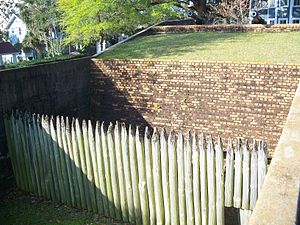
Fort George (Pensacola, Florida)
United States historic place
Distance: Approx. 312 meters
Latitude and longitude: 30.41861111,-87.21722222
Fort George was a British fort built in 1778 for the protection of Pensacola, Florida. The Spanish captured it in Siege of Pensacola on May 10, 1781 (American Revolutionary War). The fort no longer exists, though part of it was later recreated to mark its original location.

Pensacola station (Louisville and Nashville Railroad)
United States historic place
Distance: Approx. 809 meters
Latitude and longitude: 30.41722222,-87.21
The Louisville and Nashville Passenger Station and Express Building is a historic Louisville and Nashville Railroad passenger train depot in Pensacola, Florida.

Charles William Jones House
Historic house in Florida, United States
Distance: Approx. 660 meters
Latitude and longitude: 30.41611111,-87.22
The Charles William Jones House (also known as John B. Jones) is a historic home in Pensacola, Florida. Named for U.S. Senator Charles W. Jones, it is located at 302 North Barcelona Street. On December 20, 1977, it was added to the U.S. National Register of Historic Places.

King-Hooton House
Historic house in Florida, United States
Distance: Approx. 805 meters
Latitude and longitude: 30.42027778,-87.20861111
The King-Hooton House is a historic home in Pensacola, Florida. It is located at 512–514 North Seventh Avenue. On August 23, 1991, it was added to the U.S. National Register of Historic Places.

First Christian Church (Pensacola, Florida)
Historic church in Florida, United States
Distance: Approx. 742 meters
Latitude and longitude: 30.42138889,-87.20916667
The First Christian Church (also known as the Greater Mount Lily Baptist Church) is an historic church in Pensacola, Florida. It is located at 619 East Gadsden Street. On April 14, 1994, it was added to the U.S. National Register of Historic Places.
Episcopal Day School (Pensacola, Florida)
Distance: Approx. 566 meters
Latitude and longitude: 30.416319,-87.216761
Episcopal Day School (EDS) is an independent, co-educational school in Pensacola, Florida, providing courses from pre-kindergarten to grade 8 levels. The roots of Episcopal Day School date back to 1856 when an educational ministry was founded as a part of Old Christ Church. The school in its current form has operated since 1952.

Mount Zion Missionary Baptist Church (Pensacola, Florida)
Historic place in Florida, United States
Distance: Approx. 814 meters
Latitude and longitude: 30.41805556,-87.22444444
Mount Zion Missionary Baptist Church is a national historic site located at 528 West Jackson Street, Pensacola, Florida in Escambia County. It is the second oldest black Baptist church in Pensacola. It was added to the National Register of Historic Places on December 24, 2013.

Winston E. Arnow Federal Building
United States historic place
Distance: Approx. 785 meters
Latitude and longitude: 30.41444444,-87.21555556
The Winston E. Arnow Federal Building is a national historic site located at 100 N. Palafox St., Pensacola, Florida in Escambia County. Originally built as a courthouse and post office, the building was constructed in 1938 and 1939 and is an example of the Simplified Classical style frequently used for federal buildings in late 1930s and early 1940s. In 2004 it was named for district judge Winston E. Arnow.
Weather in this IP's area
clear sky
30 Celsius
37 Celsius
28 Celsius
31 Celsius
1019 hPa
82 %
1019 hPa
1017 hPa
10000 meters
2.68 m/s
4.02 m/s
52 degree
06:04:53
19:45:35