Country:
 USA
USARegion:
City:
Latitude and Longitude:
Time Zone:
Postal Code:
IP information under different IP Channel
ip-api
Country
Region
City
ASN
Time Zone
ISP
Blacklist
Proxy
Latitude
Longitude
Postal
Route
IPinfo
Country
Region
City
ASN
Time Zone
ISP
Blacklist
Proxy
Latitude
Longitude
Postal
Route
MaxMind
Country
Region
City
ASN
Time Zone
ISP
Blacklist
Proxy
Latitude
Longitude
Postal
Route
Luminati
Country
USRegion
ga
City
columbus
ASN
Time Zone
America/New_York
ISP
UNITI-FIBER
Latitude
Longitude
Postal
db-ip
Country
Region
City
ASN
Time Zone
ISP
Blacklist
Proxy
Latitude
Longitude
Postal
Route
ipdata
Country
Region
City
ASN
Time Zone
ISP
Blacklist
Proxy
Latitude
Longitude
Postal
Route
Popular places and events near this IP address

Phenix City, Alabama
City in Alabama, United States
Distance: Approx. 187 meters
Latitude and longitude: 32.47083333,-85.00277778
Phenix City is a city in Lee and Russell counties in the U.S. state of Alabama, and the county seat of Russell County. As of the 2020 Census, the population of the city was 38,817. Phenix City lies immediately west across the Chattahoochee River from Columbus, Georgia and observes Eastern Time on a de facto basis (in contrast to the rest of Alabama, which observes Central Time) due to Phenix City's strong economic ties to Columbus.
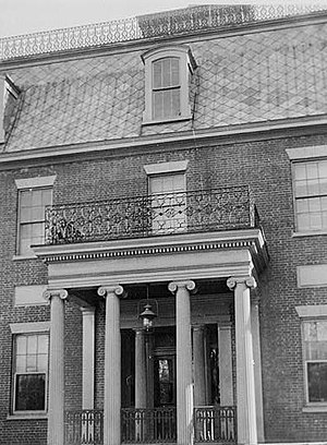
Mott House (Columbus, Georgia)
Historic house in Georgia, United States
Distance: Approx. 654 meters
Latitude and longitude: 32.47277778,-84.99416667
The Mott House was a historic residence constructed in 1839 in Columbus, Georgia. The building was listed on the National Register of Historic Places in 1974. It was destroyed by fire in 2014.
Battle of Columbus (1865)
Battle of the American Civil War
Distance: Approx. 571 meters
Latitude and longitude: 32.467,-84.997
The Battle of Columbus, Georgia (April 16, 1865), was the last conflict in the Union campaign through Alabama and Georgia, known as Wilson's Raid, in the final full month of the American Civil War. Maj. Gen.
Flowers Building
United States historic place
Distance: Approx. 898 meters
Latitude and longitude: 32.46861111,-84.99166667
The Flowers Building is a historic building constructed in 1902 in Columbus, Georgia. Its Chicago style design is by architect T. Firth Lockwood. It was listed on the National Register of Historic Places in 1980.
Broad Street Methodist Episcopal Church South
Historic church in Georgia, United States
Distance: Approx. 677 meters
Latitude and longitude: 32.47138889,-84.99361111
Broad Street Methodist Episcopal Church South ("Old" Broad Street Methodist Episcopal Church South) in Columbus, Georgia is a historic church built in 1873. It is one of the oldest buildings on Broadway (Columbus's main street) and is as the only Greek Revival church building surviving in Columbus. It has pilasters with corbelled brick capitals.
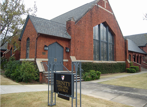
Trinity Episcopal Church (Columbus, Georgia)
Church in Columbus GA , United States
Distance: Approx. 978 meters
Latitude and longitude: 32.46777778,-84.99111111
Trinity Episcopal Church is an Episcopal church located in Columbus, Georgia.

City Fire Department (Columbus, Georgia)
United States historic place
Distance: Approx. 735 meters
Latitude and longitude: 32.47194444,-84.99305556
The City Fire Department in Columbus, Georgia, at 1338 and 1340 Broadway, is a former fire station which was built in 1920. It was listed on the National Register of Historic Places in 1980. It is Bungalow in style.
Brownville–Summerville Historic District
United States historic place
Distance: Approx. 840 meters
Latitude and longitude: 32.47777778,-85.00472222
The Brownville–Summerville Historic District is a historic district in Phenix City, Alabama. The district covers approximately 87 acres (35 ha) of mostly residential area to the west and northwest of the city's commercial core. The earliest houses in the district date from circa 1870, and are either Greek Revival or Saddlebag cottages.
Kid Alley Residential Historic District
United States historic place
Distance: Approx. 964 meters
Latitude and longitude: 32.46444444,-85.0075
The Kid Alley Residential Historic District is a historic district in Phenix City, Alabama. Located in the Girard section of the city, Kid Alley was developed in 1895 as a middle-class neighborhood of Victorian rental houses. Of the original 12 houses, seven remain, ranging from shotguns to large cottages, all with elaborate scrollwork.
Smith Residential Historic District
United States historic place
Distance: Approx. 971 meters
Latitude and longitude: 32.47972222,-85.00111111
The U. H. Smith Residential Historic District is a historic district in Phenix City, Alabama. The district consists of six late 19th century houses, centered on the house of U. H. Smith, who served as mayor of Phenix City from 1888 to 1891. The houses are primarily Victorian, some with Greek Revival details.
Snow Valley Residential Historic District
United States historic place
Distance: Approx. 770 meters
Latitude and longitude: 32.46777778,-85.00805556
The Snow Valley Residential Historic District is a historic district in Phenix City, Alabama. Located in the Girard section of the city, the land was originally owned by Bavarian immigrant farmer Henry C. Herman. Herman sold all but 2 acres (0.81 ha) of the land in 1883.
Upper Twentieth Street Residential Historic District
United States historic place
Distance: Approx. 964 meters
Latitude and longitude: 32.46444444,-85.0075
The Upper Twentieth Street Residential Historic District is a historic district in Phenix City, Alabama. The land was acquired in 1880 by Scottish mill worker and merchant John Baird from his father-in-law, S. M. Ingersoll. Baird gave his daughters two lots, and each built a house on them.
Weather in this IP's area
scattered clouds
25 Celsius
26 Celsius
25 Celsius
27 Celsius
1016 hPa
94 %
1016 hPa
1008 hPa
10000 meters
40 %
06:51:18
20:41:28