Country:
 USA
USARegion:
City:
Latitude and Longitude:
Time Zone:
Postal Code:
IP information under different IP Channel
ip-api
Country
Region
City
ASN
Time Zone
ISP
Blacklist
Proxy
Latitude
Longitude
Postal
Route
IPinfo
Country
Region
City
ASN
Time Zone
ISP
Blacklist
Proxy
Latitude
Longitude
Postal
Route
MaxMind
Country
Region
City
ASN
Time Zone
ISP
Blacklist
Proxy
Latitude
Longitude
Postal
Route
Luminati
Country
USRegion
al
City
tuscaloosa
ASN
Time Zone
America/Chicago
ISP
UNITI-FIBER
Latitude
Longitude
Postal
db-ip
Country
Region
City
ASN
Time Zone
ISP
Blacklist
Proxy
Latitude
Longitude
Postal
Route
ipdata
Country
Region
City
ASN
Time Zone
ISP
Blacklist
Proxy
Latitude
Longitude
Postal
Route
Popular places and events near this IP address

Cathedral of Saint Paul (Birmingham, Alabama)
Historic church in Alabama, United States
Distance: Approx. 373 meters
Latitude and longitude: 33.51779167,-86.80459444
The Cathedral of Saint Paul — informally known as Saint Paul's Cathedral — is the mother church of the Roman Catholic Diocese of Birmingham in Alabama in Birmingham, Alabama. Designed by Chicago architect Adolphus Druiding, the Victorian Gothic-style brick building was completed as a parish church in 1893. The parish it serves was established in 1872 and the cornerstone bears both dates.
Birmingham District
Distance: Approx. 510 meters
Latitude and longitude: 33.51666667,-86.8
The Birmingham District is a geological area in the vicinity of Birmingham, Alabama, where the raw materials for making steel - limestone, iron ore, and coal - are found together in abundance. The district includes Red Mountain, Jones Valley, and the Warrior and Cahaba coal fields in Central Alabama.
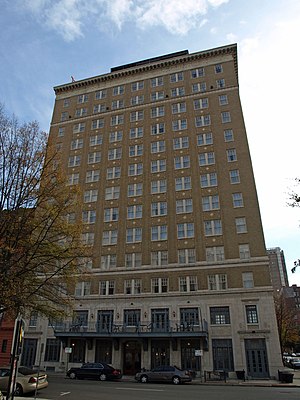
Redmont Hotel
United States historic place
Distance: Approx. 414 meters
Latitude and longitude: 33.51873333,-86.80639167
The Redmont Hotel Birmingham, or simply the Redmont Hotel, is a 14-story-tall (160 ft; 49 m), 120-room boutique hotel and conference center located on the corner of 5th Avenue North and 21st Street in Birmingham, Alabama, USA. The Redmont, named after Birmingham's Red Mountain is the oldest hotel in Birmingham still in use. It is currently owned by Bayshore Company Tampa, Florida, is managed by Rhaglan Hospitality LLC, and operates as a historic boutique hotel under the Curio Collection by Hilton brand.
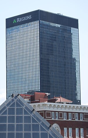
Regions Center (Birmingham)
Office tower in Birmingham, Alabama, US
Distance: Approx. 536 meters
Latitude and longitude: 33.5186,-86.8078
The Regions Center (formerly the AmSouth Center, before that the AmSouth-Sonat Tower, and originally the First National-Southern Natural Building) is a 390-foot (120-meter) tall, 30 story office tower located at the northwest corner of 20th Street and 5th Avenue North in Birmingham, Alabama, United States. The building served as the corporate headquarters for AmSouth Bancorporation from 1972 until 2006, and Sonat, Inc. and its subsidiaries from 1972 until 2007, when it relocated to the Colonial Brookwood Center.

Birmingham Terminal Station
Demolished train stop in Alabama
Distance: Approx. 380 meters
Latitude and longitude: 33.52245,-86.79908
The Birmingham Terminal Station (or simply Birmingham Terminal), completed in 1909, was the principal railway station for Birmingham, Alabama (United States) until the 1950s. It was demolished in 1969, and its loss still serves as a rallying image for local preservationists.

Birmingham Public Library
Public library in Birmingham, Alabama
Distance: Approx. 450 meters
Latitude and longitude: 33.520418,-86.807434
The Birmingham Public Library is one of the largest library systems in the southeastern United States. It consists of 19 branches, with a main or central library located in downtown Birmingham, Alabama. The main library is composed of two buildings, the East Building and the Linn-Henley Research Library containing the Tutwiler Collection of Southern History, and the Rucker Agee Map Collection.
Taste of 4th Avenue Jazz Festival
Distance: Approx. 39 meters
Latitude and longitude: 33.52055556,-86.80222222
The Taste of 4th Avenue Jazz Festival is a one-day jazz festival which has been presented annually since 2003 in Birmingham's Historic 4th Avenue District downtown. In past years, it was sponsored by the Alabama Jazz Hall of Fame (AJHoF) and Urban Impact. Beginning in 2011, the festival was presented by Magic City Smooth Jazz.
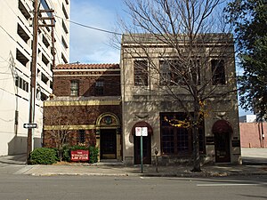
Whilldin Building
United States historic place
Distance: Approx. 438 meters
Latitude and longitude: 33.51916667,-86.80694444
The Whilldin Building is the former office of Alabama architect David Oliver Whilldin. Located on 21st Street North, now Richard Arrington Junior Boulevard North, in Birmingham, Alabama, the building was designed and built by Whilldin during 1923 and 1924 and added to the National Register of Historic Places in 1982. The site is now the office of the Wininger Law Firm.

First Presbyterian Church (Birmingham, Alabama)
Historic church in Alabama, United States
Distance: Approx. 419 meters
Latitude and longitude: 33.51833333,-86.80611111
First Presbyterian Church is an historic church at 2100 4th Avenue, North in Birmingham, Alabama. It was built in 1888 and added to the National Register of Historic Places in 1982. It is a member of the Presbytery of Sheppards & Lapsley.
Concord Center
Office building in Alabama, US
Distance: Approx. 453 meters
Latitude and longitude: 33.51733333,-86.80533333
The Concord Center is an 11-story, 145 foot-tall (44m), Class-A office building located in downtown Birmingham, Alabama. The building is located on the site of the former Jefferson County Courthouse, which was Birmingham's first skyscraper. The two 30-foot illuminated pyramids atop the building are meant to reflect the two pyramids that were atop the former Jefferson County Courthouse.
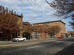
Morris Avenue–First Avenue North Historic District
Historic district in Alabama, United States
Distance: Approx. 523 meters
Latitude and longitude: 33.51611111,-86.80138889
The Morris Avenue Historic District is an industrial district in Birmingham, Alabama. The district covers Morris Avenue from 20th Street to 25th Street and First Avenue from 21st to 26th Street. The Morris Avenue section comprises a set of late 19th century masonry warehouses that were Birmingham's main food distribution center until the 1950s.

Age-Herald Building
Building in Birmingham, Alabama
Distance: Approx. 400 meters
Latitude and longitude: 33.51861111,-86.80611111
The Age-Herald Building, at 2107 5th Ave. N in Birmingham, Alabama, was built in 1910. It was listed on the National Register of Historic Places in 1984.
Weather in this IP's area
overcast clouds
25 Celsius
25 Celsius
23 Celsius
26 Celsius
1016 hPa
94 %
1016 hPa
995 hPa
10000 meters
1.2 m/s
2.42 m/s
47 degree
89 %
05:56:20
19:50:51