Country:
 USA
USARegion:
City:
Latitude and Longitude:
Time Zone:
Postal Code:
IP information under different IP Channel
ip-api
Country
Region
City
ASN
Time Zone
ISP
Blacklist
Proxy
Latitude
Longitude
Postal
Route
IPinfo
Country
Region
City
ASN
Time Zone
ISP
Blacklist
Proxy
Latitude
Longitude
Postal
Route
MaxMind
Country
Region
City
ASN
Time Zone
ISP
Blacklist
Proxy
Latitude
Longitude
Postal
Route
Luminati
Country
USRegion
la
City
neworleans
ASN
Time Zone
America/Chicago
ISP
UNITI-FIBER
Latitude
Longitude
Postal
db-ip
Country
Region
City
ASN
Time Zone
ISP
Blacklist
Proxy
Latitude
Longitude
Postal
Route
ipdata
Country
Region
City
ASN
Time Zone
ISP
Blacklist
Proxy
Latitude
Longitude
Postal
Route
Popular places and events near this IP address

Houma, Louisiana
City in Louisiana, United States
Distance: Approx. 977 meters
Latitude and longitude: 29.5875,-90.71611111
Houma ( HOH-mə) is the largest city in and the parish seat of Terrebonne Parish in the U.S. state of Louisiana. It is also the largest principal city of the Houma–Bayou Cane–Thibodaux metropolitan statistical area. The city's government was absorbed by the parish in 1984, which currently operates as the Terrebonne Parish Consolidated Government.
Vandebilt Catholic High School
Private, catholic, coeducational school in Houma, , Louisiana
Distance: Approx. 2958 meters
Latitude and longitude: 29.60361111,-90.74861111
Vandebilt Catholic High School is a private diocesan co-educational institution for grades 8-12 located in Terrebonne Parish, Louisiana and in the Roman Catholic Diocese of Houma-Thibodaux. It is located in the unincorporated area of Bayou Cane, near Houma.

Roman Catholic Diocese of Houma–Thibodaux
Latin Catholic jurisdiction in the United States
Distance: Approx. 977 meters
Latitude and longitude: 29.5875,-90.71611111
The Diocese of Houma–Thibodaux (Latin: Dioecesis Humensis–Thibodensis) is a Latin Church ecclesiastical territory or diocese of the Catholic Church in southeastern Louisiana. It covers Terrebonne, Lafourche, and the eastern part of St. Mary parishes, Morgan City, and Grand Isle in Jefferson Parish.
Houma Terrebonne Civic Center
Arena in Louisiana, United States
Distance: Approx. 1828 meters
Latitude and longitude: 29.580143,-90.725094
The Barry P. Bonvillain Civic Center, formerly known as the Houma-Terrebonne Civic Center, is a 5,000-seat multi-purpose arena in Houma, Louisiana, USA, that hosts corporate functions, such as meetings, training seminars, conferences, as well as formal banquets, wedding receptions, group conventions, consumer shows, professional wrestling, family theater and other performing arts, concerts, graduations, religious services, indoor and outdoor festivals. It is also home to the annual Ducks Unlimited banquet in Terrebonne Parish. It opened on January 6, 1999.
Terrebonne High School
Public school in Houma, Louisiana, United States
Distance: Approx. 1746 meters
Latitude and longitude: 29.59944444,-90.73694444
Terrebonne High School is a high school in Houma, Louisiana. It is a part of the Terrebonne Parish School District.

KJIN
Radio station in Houma, Louisiana
Distance: Approx. 2940 meters
Latitude and longitude: 29.57055556,-90.72833333
KJIN (1490 kHz) is a commercial AM radio station in Houma, Louisiana. It is owned by Lisa D. Stiglets, under the corporate name JLE, Incorporated, and airs an urban adult contemporary radio format. The studios and offices are on West Main Street in Houma.
Belle Grove (Terrebonne Parish, Louisiana)
Human settlement in Louisiana, United States of America
Distance: Approx. 2873 meters
Latitude and longitude: 29.57,-90.72
Belle Grove, was a sugarcane plantation, on the banks of the Bayou Black, Terrebonne Parish, Louisiana, built in 1847. In 1881, it was purchased by James M. McBride from the Marcellus Daunis heirs. It was demolished in the 1950s.
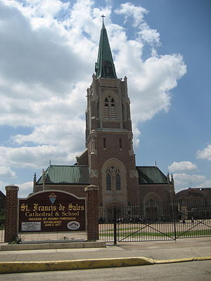
Cathedral of St. Francis de Sales (Houma, Louisiana)
Church in Louisiana, United States
Distance: Approx. 350 meters
Latitude and longitude: 29.59466,-90.72277
The Cathedral of St. Francis de Sales is a Catholic cathedral located in Houma, Louisiana, United States. Along with St.
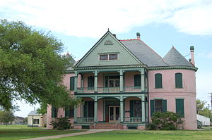
Southdown Plantation
Historic house in Louisiana, United States
Distance: Approx. 2168 meters
Latitude and longitude: 29.58875,-90.74027778
Southdown Plantation is a historic Southern plantation in Terrebonne Parish, Louisiana.
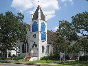
St. Matthew's Episcopal Church (Houma, Louisiana)
Historic church in Louisiana, United States
Distance: Approx. 123 meters
Latitude and longitude: 29.59666667,-90.71861111
St. Matthew's Episcopal Church is a parish of the Episcopal Church in Houma, Louisiana, in the Episcopal Diocese of Louisiana. It is noted for its historic church at 243 Barrow Street, which was built in 1892 and added to the National Register of Historic Places in 1989.
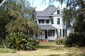
Clifford Percival Smith House
United States historic place
Distance: Approx. 439 meters
Latitude and longitude: 29.59972222,-90.71888889
The Clifford Percival Smith House, also known as the Walker House, is a historic house in Houma, Louisiana, U.S.. It was built circa 1905 for Clifford Percival Smith and his wife, Clara. It belonged to the Smith family until 1986.
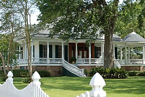
Residence Plantation House
United States historic place
Distance: Approx. 2937 meters
Latitude and longitude: 29.59805556,-90.68916667
The Residence Plantation House is a historic house on a former plantation in Houma, Louisiana, U.S.. It was built in 1898 for Roberta Barrow, the daughter of sugar planter Robert Ruffin Barrow. Her father lived in a house on the plantation; Roberta "demolished her father's antebellum home and built the current structure on its site." Her grandfather was the owner of Afton Villa.
Weather in this IP's area
clear sky
30 Celsius
37 Celsius
28 Celsius
32 Celsius
1016 hPa
80 %
1016 hPa
1016 hPa
10000 meters
2.74 m/s
3.7 m/s
232 degree
10 %
06:19:53
19:58:39