Country:
 USA
USARegion:
City:
Latitude and Longitude:
Time Zone:
Postal Code:
IP information under different IP Channel
ip-api
Country
Region
City
ASN
Time Zone
ISP
Blacklist
Proxy
Latitude
Longitude
Postal
Route
IPinfo
Country
Region
City
ASN
Time Zone
ISP
Blacklist
Proxy
Latitude
Longitude
Postal
Route
MaxMind
Country
Region
City
ASN
Time Zone
ISP
Blacklist
Proxy
Latitude
Longitude
Postal
Route
Luminati
Country
USRegion
fl
City
daytonabeach
ASN
Time Zone
America/New_York
ISP
UNITI-FIBER
Latitude
Longitude
Postal
db-ip
Country
Region
City
ASN
Time Zone
ISP
Blacklist
Proxy
Latitude
Longitude
Postal
Route
ipdata
Country
Region
City
ASN
Time Zone
ISP
Blacklist
Proxy
Latitude
Longitude
Postal
Route
Popular places and events near this IP address

Lakeside, Florida
Census-designated place in Florida
Distance: Approx. 6452 meters
Latitude and longitude: 30.13472222,-81.76583333
Lakeside is an unincorporated area and census-designated place in Clay County, Florida, United States. It is part of the greater Orange Park area and is included in the Jacksonville, Florida Metropolitan Statistical Area. The population was 31,275 at the 2020 census, up from 30,943 at the 2010 census.
St. Johns Country Day School
Private school in Florida
Distance: Approx. 6234 meters
Latitude and longitude: 30.1450904,-81.7432511
St. Johns Country Day School is an independent, coeducational private college preparatory school founded in 1953 in Orange Park, Florida, U.S.. It offers a PK–12 education, including a preschool, an elementary school, a middle school, and a high school, and maintains an enrollment of about 450 students each year.

Switzerland, Florida
Community in Florida, United States
Distance: Approx. 7186 meters
Latitude and longitude: 30.07611111,-81.64722222
Switzerland is an unincorporated community in northwest St. Johns County, Florida, United States, adjacent to Fruit Cove. Along with Fruit Cove, the community is associated to the zip code 32259.
Fleming Island, Florida
Census-designated place in Florida, United States
Distance: Approx. 6 meters
Latitude and longitude: 30.09305556,-81.71916667
Fleming Island is an unincorporated community and census-designated place (CDP) in Clay County, Florida, United States. It is located 21 miles (34 km) southwest of downtown Jacksonville, on the western side of the St. Johns River, off US 17.
Hibernia, Florida
Unincorporated community in Florida, United States
Distance: Approx. 3747 meters
Latitude and longitude: 30.065,-81.69777778
Hibernia is an unincorporated community in Clay County, Florida, United States. It is located off US 17, on the western bank of the St. Johns River.
Doctors Inlet, Florida
Unincorporated community in Florida, United States
Distance: Approx. 5561 meters
Latitude and longitude: 30.1,-81.77638889
Doctors Inlet is an unincorporated community in Clay County, Florida, United States. It is located near the intersection of County Roads 220 and 224, and is adjacent to the communities of Middleburg, Orange Park, and Lakeside.
Princess Mound
United States historic place
Distance: Approx. 354 meters
Latitude and longitude: 30.09,-81.72
The Princess Mound is a historic site near Green Cove Springs, Florida. It is located on Fleming Island, northwest of Green Cove Springs. On March 2, 1990, it was added to the U.S. National Register of Historic Places.
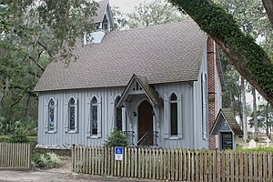
St. Margaret's Episcopal Church and Cemetery
Historic church in Florida, United States
Distance: Approx. 3607 meters
Latitude and longitude: 30.06722222,-81.69666667
St. Margaret's Episcopal Church and Cemetery is a historic Carpenter Gothic church and cemetery located at 6874 Old Church Road in Hibernia, in Fleming Island, near Green Cove Springs, Florida, in the United States. On June 4, 1973, the church and its cemetery, which is also known as the Hibernia Cemetery, were added to the National Register of Historic Places.

Doctors Lake (Florida)
Lake in the state of Florida, United States
Distance: Approx. 6757 meters
Latitude and longitude: 30.15277778,-81.70638889
Doctors Lake is a body of water located off the St. Johns River in Clay County, Florida. Despite its name, it is not a true lake, as it is actually an inlet, openly connected to the St.

Black Creek (Florida)
River in Florida, United States of America
Distance: Approx. 5699 meters
Latitude and longitude: 30.042424,-81.710815
Black Creek is a tributary of the St. Johns River in Clay County, Florida. It is formed by the confluence of North Fork Black Creek and South Fork Black Creek.
WAYR (AM)
Radio station in Fleming Island, Florida
Distance: Approx. 7160 meters
Latitude and longitude: 30.07277778,-81.78972222
WAYR (550 kHz) is a non-commercial radio station licensed to Fleming Island, Florida, and serving the Jacksonville metropolitan area. It broadcasts a Christian Talk and Teaching radio format, and is owned by Good Tidings Trust, Inc. WAYR calls itself "Way Radio" but it is not associated with another Christian radio organization, the Colorado Springs-based "WayFM Network." WAYR's studios and offices are on Russell Road in Green Cove Springs.
Fleming Island High School
School in the United States
Distance: Approx. 915 meters
Latitude and longitude: 30.0871,-81.7127
Fleming Island High School (FIHS) is a public senior high school located in Fleming Island, Florida and is part of the Clay County School District. The school opened in 2003 and has an enrollment of approximately 2,000 students. The team name is the Golden Eagles and the school colors are green and gold.
Weather in this IP's area
scattered clouds
30 Celsius
37 Celsius
29 Celsius
32 Celsius
1017 hPa
76 %
1017 hPa
1017 hPa
10000 meters
3.09 m/s
270 degree
40 %
06:42:54
20:23:37