Country:
 USA
USARegion:
City:
Latitude and Longitude:
Time Zone:
Postal Code:
IP information under different IP Channel
ip-api
Country
Region
City
ASN
Time Zone
ISP
Blacklist
Proxy
Latitude
Longitude
Postal
Route
IPinfo
Country
Region
City
ASN
Time Zone
ISP
Blacklist
Proxy
Latitude
Longitude
Postal
Route
MaxMind
Country
Region
City
ASN
Time Zone
ISP
Blacklist
Proxy
Latitude
Longitude
Postal
Route
Luminati
Country
USRegion
la
City
neworleans
ASN
Time Zone
America/Chicago
ISP
UNITI-FIBER
Latitude
Longitude
Postal
db-ip
Country
Region
City
ASN
Time Zone
ISP
Blacklist
Proxy
Latitude
Longitude
Postal
Route
ipdata
Country
Region
City
ASN
Time Zone
ISP
Blacklist
Proxy
Latitude
Longitude
Postal
Route
Popular places and events near this IP address

WWOZ
Community radio station in New Orleans
Distance: Approx. 269 meters
Latitude and longitude: 29.9571,-90.0754
WWOZ (90.7 FM) is a non-profit community-supported radio station in New Orleans. It is owned by the New Orleans Jazz & Heritage Foundation. The station specializes in music from or relating to the cultural heritage of New Orleans and the surrounding region of Louisiana.

Saenger Theatre (New Orleans)
Theatre
Distance: Approx. 249 meters
Latitude and longitude: 29.95579722,-90.07284444
Saenger Theatre is an atmospheric theatre in downtown New Orleans, Louisiana, which is on the National Register of Historic Places. Once the flagship of Julian and Abe Saenger's theatre empire, today it is one of only a handful of Saenger movie palaces that remain.

Charity Hospital (New Orleans)
Hospital in New Orleans, Louisiana
Distance: Approx. 290 meters
Latitude and longitude: 29.9554,-90.078
Charity Hospital was one of two teaching hospitals which were part of the Medical Center of Louisiana at New Orleans (MCLNO), the other being University Hospital. Three weeks after the events of Hurricane Katrina, then-Governor Kathleen Blanco said that Charity Hospital would not reopen as a functioning hospital. The Louisiana State University System, which owns the building, stated that it had no plans to reopen the hospital in its original location.

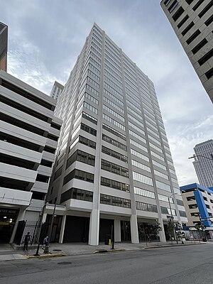
1010 Common
United States historic place
Distance: Approx. 188 meters
Latitude and longitude: 29.95361111,-90.07361111
1010 Common (formerly the Bank of New Orleans Building), located at 1010 Common Street in the Central Business District of New Orleans, Louisiana, is a 31-story skyscraper. The building, designed by Skidmore, Owings & Merrill and completed in 1970, is an example of the international style typical of the time. It is located adjacent to the 14-story Latter Center Garage & Annex.
New Orleans Exchange Centre
Building in LA , United States
Distance: Approx. 259 meters
Latitude and longitude: 29.953075,-90.073171
New Orleans Exchange Centre, formerly known as Chevron Place, located at 935 Gravier Street in the Central Business District of New Orleans, Louisiana, is a 21-story, 238 feet (73 m)-tall skyscraper designed in the international style by Stanley Muller & Associates. Kingfish Development purchased the building from Chevron in 2010, using it primarily as leasable office space for more than a dozen businesses.

Orpheum Theater (New Orleans)
United States historic place
Distance: Approx. 252 meters
Latitude and longitude: 29.95444444,-90.0725
The Orpheum Theater is a theater in the Central Business District of New Orleans, Louisiana. Also known as the RKO Orpheum, it was designed by G. Albert Lansburgh, built in 1918, and opened for vaudeville in 1921. The Beaux Arts style building has 1,500 seats, and went on to host silent movies, “talkies,” live music and a range of other shows.

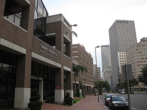
Tulane University School of Public Health and Tropical Medicine
Distance: Approx. 281 meters
Latitude and longitude: 29.95722,-90.07529
The Tulane School of Public Health and Tropical Medicine is part of Tulane University, located in New Orleans, in the U.S. state of Louisiana.

State Palace Theatre (New Orleans)
Distance: Approx. 185 meters
Latitude and longitude: 29.95546944,-90.0734
State Palace Theatre is a performing arts venue located in downtown New Orleans, Louisiana. It is located at the uptown lake corner of Canal Street and Rampart Street. The Saenger Theater is directly opposite the State Palace on Canal Street.
Tulane Medical Center
Hospital in Louisiana, United States
Distance: Approx. 131 meters
Latitude and longitude: 29.955658,-90.075884
The Tulane Medical Center is an Emergency Department located in New Orleans, Louisiana. The Tulane Medical Center has centers and clinics covering nearly all major specialties of medicine, and is the primary teaching hospital for the Tulane University School of Medicine. The hospital is jointly owned by LCMC Health and Tulane University (17.5%).

Southern Railway Terminal (New Orleans)
Distance: Approx. 278 meters
Latitude and longitude: 29.9565,-90.0731
The Southern Railway Terminal, originally officially "New Orleans Terminal", in New Orleans was constructed by the Southern Railway in 1908 on the neutral ground of Basin Street at the intersection of Canal Street. The building was designed by Daniel Burnham, who was also the architect for the Union Station in Washington D.C. The station also served the New Orleans and Northeastern Railroad and the New Orleans Terminal Company. It was the terminus for many of Southern's premier trains, most notably the Crescent.

Oil and Gas Building
Building in New Orleans, Louisiana, U.S.
Distance: Approx. 118 meters
Latitude and longitude: 29.95401004,-90.0741666
The Oil and Gas Building, or Oil & Gas Building, is a 14-story building, completed in 1959, at 1100 Tulane Avenue in the Central Business District of New Orleans, Louisiana, in the United States. Its original architects were August Perez / Edward B. Silverstein. It is now listed on the National Register of Historic Places.
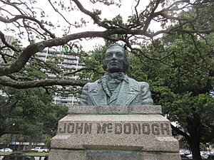
Bust of John McDonogh
Monument to American slave owner
Distance: Approx. 184 meters
Latitude and longitude: 29.9532,-90.0759
A bust of John McDonogh was installed in New Orleans, Louisiana, United States in 1938, as part of the Federal Art Project. It was created by Angela Gregory, a New Orleans native, and was erected at what was designated "McDonogh Place", a small park in Uptown New Orleans at St. Charles Avenue and Toledano Street.
Weather in this IP's area
thunderstorm
31 Celsius
37 Celsius
29 Celsius
33 Celsius
1015 hPa
71 %
1015 hPa
1015 hPa
10000 meters
4.12 m/s
30 degree
75 %
06:16:37
19:56:45