Country:
 New Zealand
Region:
City:
Latitude and Longitude:
Time Zone:
Postal Code:
IP information under different IP Channel
ip-api
Country
Region
City
ASN
Time Zone
ISP
Blacklist
Proxy
Latitude
Longitude
Postal
Route
IPinfo
Country
Region
City
ASN
Time Zone
ISP
Blacklist
Proxy
Latitude
Longitude
Postal
Route
MaxMind
Country
Region
City
ASN
Time Zone
ISP
Blacklist
Proxy
Latitude
Longitude
Postal
Route
Luminati
Country
NZRegion
auk
City
auckland
ASN
Time Zone
Pacific/Auckland
ISP
Cato Networks Ltd
Latitude
Longitude
Postal
db-ip
Country
Region
City
ASN
Time Zone
ISP
Blacklist
Proxy
Latitude
Longitude
Postal
Route
ipdata
Country
Region
City
ASN
Time Zone
ISP
Blacklist
Proxy
Latitude
Longitude
Postal
Route
Popular places and events near this IP address

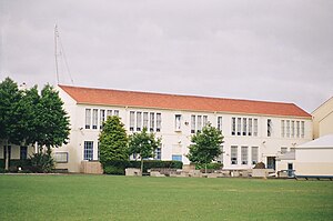
Auckland Grammar School
School in Auckland, New Zealand
Distance: Approx. 368 meters
Latitude and longitude: -36.86916667,174.76944444
Founded in 1869, Auckland Grammar School (often simplified to Auckland Grammar, or Grammar) is a state, day and boarding secondary school for boys in Epsom, Auckland, New Zealand. The school was originally situated on Howe Street in Freeman’s Bay, where Auckland Girls Grammar School is now located. It moved to its current site on Mountain Road in Epsom in 1916.

Mount Eden Prisons
Two prison facilities in Mount Eden, Auckland, New Zealand
Distance: Approx. 54 meters
Latitude and longitude: -36.8671543,174.7669029
Mount Eden Prisons consists of two separate facilities in the Auckland, New Zealand suburb of Mount Eden — the Mount Eden Prison and the Mount Eden Corrections Facility.
St Peter's College, Auckland
School in Auckland, New Zealand
Distance: Approx. 214 meters
Latitude and longitude: -36.8675,174.76888889
St Peter's College (Māori: Te Kura Teitei o Hāto Petera) is a Catholic secondary school for boys in the Edmund Rice tradition, and dedicated to St Peter. It is located in the central Auckland area of Grafton, Auckland, New Zealand. With a roll of over 1300, the school is one of the largest Catholic schools in New Zealand.

Colonial Ammunition Company
Former ammunition manufacturing company from New Zealand
Distance: Approx. 365 meters
Latitude and longitude: -36.868665,174.763421
The Colonial Ammunition Company (CAC) was an ammunition manufacturer in Auckland, New Zealand. Its predecessor, Whitney & Sons, was established by John Whitney with government encouragement in 1885 during the Russian Scare. Whitney later recruited investors to expand his factory in 1888.

Grafton railway station, Auckland
Railway station in New Zealand
Distance: Approx. 331 meters
Latitude and longitude: -36.8655,174.7701
Grafton railway station is a station serving the inner-city suburb of Grafton in Auckland, New Zealand. It is located on the Western Line of Auckland's passenger rail network and consists of an island platform located in a trench near the intersection of Khyber Pass Road and Park Road. The station opened on 11 April 2010.

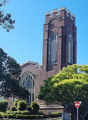
Church of the Holy Sepulchre, Auckland
Historic church in Auckland, New Zealand
Distance: Approx. 400 meters
Latitude and longitude: -36.864843,174.76285074
The Church of the Holy Sepulchre (Māori: Te Ana Tapu), commonly known as Holy Sep and St Sepulchre's, is an historic Anglican church located on Khyber Pass Road, Grafton, near the central business district of Auckland, New Zealand. The church and wider marae complex are also known as (Māori: Te Mīhana Māori o Tāmaki Makaurau or Te Mīhana Māori). Established in 1880, the church has played an important role in the history and development of the Anglican Church in Auckland, being first a central parish church, then the home of the Māori Anglican Mission (Te Mīhana Māori).

The Mind Lab
New Zealand Private Training Establishment
Distance: Approx. 291 meters
Latitude and longitude: -36.8649169,174.7643042
The Mind Lab is a New Zealand Private Training Establishment (PTE) that has degree awarding powers through the New Zealand Qualifications Authority (NZQA), identified as The Mind Lab Limited Partnership. It is based in Auckland.

The Powerstation
Music venue in Eden Terrace, Auckland
Distance: Approx. 494 meters
Latitude and longitude: -36.86624411,174.76118174
The Powerstation is a music venue in Eden Terrace, Auckland, it is one of the few remaining small music venues in New Zealand. The building has been used as multiple different music venues since the 1950s.

Khyber Pass Road
Street in central Auckland, New Zealand
Distance: Approx. 273 meters
Latitude and longitude: -36.8657,174.7695
Khyber Pass Road is a street in the Auckland City Centre, New Zealand, connecting Upper Symonds Street to Broadway in Newmarket. The road is intersected by both the Western Line and the Auckland Southern Motorway.

New North Road, New Zealand
Street in Auckland, New Zealand
Distance: Approx. 273 meters
Latitude and longitude: -36.8657,174.7695
New North Road is a street in the central and western Auckland isthmus, New Zealand, connecting Upper Symonds Street in Eden Terrace to Avondale. The road runs parallel to Great North Road, located to the north, and crosses Dominion Road, the Western Line at Morningside and runs above the Waterview Tunnel section of the Southwestern Motorway at Mount Albert.
Mount Eden shot tower
Former Colonial Ammunition Company Shot Tower
Distance: Approx. 365 meters
Latitude and longitude: -36.86865,174.7634
The Colonial Ammunition Company Shot Tower, also known as the Mount Eden shot tower was an early 20th century shot tower located in Mount Eden, Auckland, New Zealand and listed as a Category I building by Heritage New Zealand. The shot tower was originally owned by the Colonial Ammunition Company and was in use until the 1980s. In 2001 the rest of the buildings were demolished but the tower was spared due to popular support for it.
Kāhui St David's
Music and community centre in Auckland, New Zealand
Distance: Approx. 410 meters
Latitude and longitude: -36.8641,174.76344
Kāhui St David's is a music and community centre in Khyber Pass Road, Auckland, New Zealand. It is housed in the historic former St David's Presbyterian Church which was built as a memorial church to soldiers. It was also known as the Soldiers' Church or St David's Memorial Church.
Weather in this IP's area
scattered clouds
17 Celsius
16 Celsius
16 Celsius
17 Celsius
1022 hPa
62 %
1022 hPa
1012 hPa
10000 meters
4.02 m/s
5.36 m/s
326 degree
40 %
07:22:37
17:32:00