Country:
 The Philippines
Region:
City:
Latitude and Longitude:
Time Zone:
Postal Code:
IP information under different IP Channel
ip-api
Country
Region
City
ASN
Time Zone
ISP
Blacklist
Proxy
Latitude
Longitude
Postal
Route
IPinfo
Country
Region
City
ASN
Time Zone
ISP
Blacklist
Proxy
Latitude
Longitude
Postal
Route
MaxMind
Country
Region
City
ASN
Time Zone
ISP
Blacklist
Proxy
Latitude
Longitude
Postal
Route
Luminati
Country
PHRegion
00
City
manila
ASN
Time Zone
Asia/Manila
ISP
Cato Networks Ltd
Latitude
Longitude
Postal
db-ip
Country
Region
City
ASN
Time Zone
ISP
Blacklist
Proxy
Latitude
Longitude
Postal
Route
ipdata
Country
Region
City
ASN
Time Zone
ISP
Blacklist
Proxy
Latitude
Longitude
Postal
Route
Popular places and events near this IP address
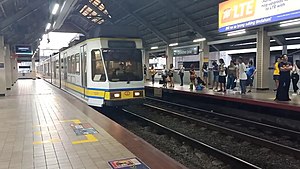
Doroteo Jose station
Train station in Manila, Philippines
Distance: Approx. 143 meters
Latitude and longitude: 14.605475,120.98206944
Doroteo Jose station is an elevated Light Rail Transit (LRT) station located on the LRT Line 1 (LRT-1) system in Santa Cruz, Manila. The station is situated on Rizal Avenue and slightly past Doroteo Jose Street. Both the station and the street are named after Doroteo Jose, a Filipino who was arrested by Spanish authorities in 1898 for leading a movement against a corrupt archbishop.

Recto station
LRT Line 2 station in Manila
Distance: Approx. 151 meters
Latitude and longitude: 14.60349722,120.98340278
Recto station is the western terminus of the Light Rail Transit Line 2 (LRT-2) system. It is situated on Recto Avenue at the district boundary of Santa Cruz and Quiapo, Manila.
Philippine College of Health Sciences
Private college in Manila, Philippines
Distance: Approx. 352 meters
Latitude and longitude: 14.60326,120.98532
The Philippine College of Health Sciences, Inc. (PCHS) is a private school located at 1813 Recto Avenue in Manila, Philippines. It was founded in 1993 by Dr.

Dr. Jose Fabella Memorial Hospital
Government hospital in Manila, Philippines
Distance: Approx. 312 meters
Latitude and longitude: 14.606223,120.984202
Dr. Jose Fabella Memorial Hospital, the National Maternity Hospital, is a maternal and newborn tertiary hospital located in Santa Cruz, Manila in the Philippines. It also houses the Jose Fabella Memorial Hospital School of Midwifery, one of the best-performing institutions recognized by the Professional Regulation Commission in the Midwife Licensure Examinations.
Manila Grand Opera House
Former opera house in Manila, Philippines
Distance: Approx. 158 meters
Latitude and longitude: 14.60548056,120.98156389
The Manila Grand Opera House (Filipino: Marangal na Bahay-Opera ng Maynila, abbreviated MGOH) was a theater and opera house located in the district of Santa Cruz in Manila on the intersection of Rizal Avenue and Doroteo Jose Street. It was the Philippines' premiere entertainment venue during the Spanish and American colonial periods and the most popular theater in the 1900s. It was also the site of historically significant political meetings.
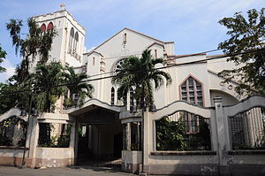
Knox United Methodist Church
United Methodist church in Manila, Philippines
Distance: Approx. 234 meters
Latitude and longitude: 14.60628,120.9825
Knox United Methodist Church is known to be the first Filipino United Methodist Church in the Philippines located along Rizal Avenue in Santa Cruz, Manila. The first Protestant worship service in the Philippines was held in Manila on August 28, 1898, officiated by Rev. George C. Stull, a Methodist chaplain and a member of the Montana Annual Conference.
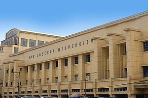
Far Eastern University
Private university in Manila, Philippines
Distance: Approx. 358 meters
Latitude and longitude: 14.6038,120.9855
Far Eastern University (Filipino: Pamantasan ng Malayong Silanganan), also referred to by its acronym FEU, is a private research non-sectarian university in Manila, Philippines. Created by the merger of Far Eastern College and the Institute of Accounts, Business and Finance, FEU became a university in 1934 during the term of its first president, Nicanor Reyes Sr. The first accountancy school for Filipinos, the university has expanded its course offerings to the arts and sciences, architecture, fine arts, education, engineering, computer studies, graduate studies, tourism and hotel management, law, nursing, and medicine.

Manila Patriotic School
Private Chinese school in Manila, Philippines
Distance: Approx. 254 meters
Latitude and longitude: 14.60315,120.98011
Manila Patriotic School is a Mandarin, Cantonese Chinese school located in Tomas Mapua Street, Santa Cruz, Manila, Philippines. It was founded in November 1912, and is recognized as one of the oldest Chinese Filipino schools City of Manila and in the Philippines. Private, non-sectarian and funded by alumni association of the school.

Philippine College of Criminology
Private college in Manila, Philippines
Distance: Approx. 275 meters
Latitude and longitude: 14.60194,120.98323
The Philippine College of Criminology (PCCR) is a private, non-sectarian, coeducational secondary and higher education institution located in Quiapo, Manila, Philippines. It is currently led by Ma. Angelica Lei Bautista as president.

Quezon Boulevard
Road in Manila, Philippines
Distance: Approx. 300 meters
Latitude and longitude: 14.60305556,120.98472222
Quezon Boulevard is a short stretch of highway in Manila, Philippines running north–south through the district of Quiapo. It is a six- to ten-lane 1.1-kilometer-long (0.68 mi) divided boulevard designated as a component of National Route 170 (N170) of the Philippine highway network, except for its service roads, and Radial Road 8 (R-8) of Manila's arterial road network which links the center of Manila to North Luzon Expressway in Quezon City in the north. The boulevard is the main access to the popular Quiapo Church and is one of the main thoroughfares of the University Belt area.

Manila City Jail
Jail in Manila
Distance: Approx. 172 meters
Latitude and longitude: 14.60485537,120.98364904
The Manila City Jail, popularly known as Old Bilibid Prison, is a detention center in Manila, Philippines. It is one of the most overcrowded jails in the world.

Ruby Tower
Former building in Manila, Philippines
Distance: Approx. 307 meters
Latitude and longitude: 14.60555556,120.97972222
The Ruby Tower was a six-story building in Manila, Philippines, completed c. 1965 that collapsed on August 2, 1968, during the Casiguran earthquake killing over 250 people.
Weather in this IP's area
light rain
28 Celsius
33 Celsius
27 Celsius
28 Celsius
1010 hPa
89 %
1010 hPa
1008 hPa
9000 meters
1.03 m/s
75 %
05:38:16
18:26:38