Country:
Region:
City:
Latitude and Longitude:
Time Zone:
Postal Code:
IP information under different IP Channel
ip-api
Country
Region
City
ASN
Time Zone
ISP
Blacklist
Proxy
Latitude
Longitude
Postal
Route
IPinfo
Country
Region
City
ASN
Time Zone
ISP
Blacklist
Proxy
Latitude
Longitude
Postal
Route
MaxMind
Country
Region
City
ASN
Time Zone
ISP
Blacklist
Proxy
Latitude
Longitude
Postal
Route
Luminati
Country
Region
nj
City
pleasantville
ASN
Time Zone
America/New_York
ISP
CL-1379-14537
Latitude
Longitude
Postal
db-ip
Country
Region
City
ASN
Time Zone
ISP
Blacklist
Proxy
Latitude
Longitude
Postal
Route
ipdata
Country
Region
City
ASN
Time Zone
ISP
Blacklist
Proxy
Latitude
Longitude
Postal
Route
Popular places and events near this IP address

Truckee Meadows
Valley in Nevada, US
Distance: Approx. 8347 meters
Latitude and longitude: 39.45,-119.75
The Truckee Meadows is a valley in Northern Nevada, named for the Truckee River, which collects and drains all water in the valley. Truckee Meadows is also colloquially used as a name for the Reno–Sparks metropolitan area, even though the metro area includes areas outside this valley. The name for the valley in the Washo language is Welganuk.

Steamboat Springs (Nevada)
Geothermal area in Nevada, United States
Distance: Approx. 4029 meters
Latitude and longitude: 39.388,-119.74
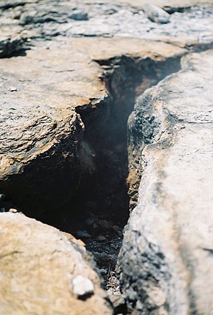
Steamboat Springs is a small volcanic field of rhyolitic lava domes and flows in western Nevada, located south of Reno. There is extensive geothermal activity in the area, including numerous hot springs, steam vents, and fumaroles. The residential portions of this area, located mostly east of Steamboat Creek and south of modern-day SR 341, are now known simply as Steamboat.

Pleasant Valley, Nevada
Unincorporated community in the state of Nevada, United States
Distance: Approx. 8222 meters
Latitude and longitude: 39.3525,-119.77611111
Pleasant Valley is a very small, unincorporated community in Washoe County, Nevada, United States. The ZIP Code for Pleasant Valley is 89521. The community is part of the Reno–Sparks Metropolitan Statistical Area.
Galena High School (Nevada)
Public secondary school in Reno, Nevada , United States
Distance: Approx. 7215 meters
Latitude and longitude: 39.387387,-119.777026
Galena High School is a public secondary school in Southwest Reno, Nevada that is a part of the Washoe County School District. The school mascot is the Grizzly Bear, and the school's colors are black and gold. Their sports teams are known as the "Galena Grizzlies".
Damonte Ranch High School
Public school
Distance: Approx. 4238 meters
Latitude and longitude: 39.424036,-119.713082
The Damonte Ranch High School (DRHS) opened in the Fall of 2003. Located in the Truckee Meadows, the school is the newest public high school in the Washoe County School District. Located in southeast Reno, the High School is named for the Damonte Ranch development during the rapid expansion of Reno NV. The Damonte Ranch High School DRHS opened as a combined middle school and high school, to help alleviate the overcrowding at Pine Middle School until Depoali Middle School was built.
Bishop Manogue High School
Private, coeducational school in Reno, Nevada, United States
Distance: Approx. 7227 meters
Latitude and longitude: 39.42361111,-119.76444444
Bishop Manogue Catholic High School is a Catholic high school in Reno, Nevada. It is the only Catholic high school in the Roman Catholic Diocese of Reno and one of only two Catholic high schools in the state of Nevada.
Shayden Summit
Shopping mall in Nevada, United States
Distance: Approx. 5215 meters
Latitude and longitude: 39.4045,-119.7505
Shayden Summit Reno (formerly The Summit Sierra and The Summit Reno) is an upscale lifestyle center located in Reno, Nevada, United States. The center opened in 2007 and is anchored by the Reno area's (and, to a fuller extent, northern Nevada's) only Dillard's. Shayden Summit is owned by Nevada-based Rhino Investments Group.

Alamo Ranchhouse
Historic house in Nevada, United States
Distance: Approx. 6004 meters
Latitude and longitude: 39.36416667,-119.755
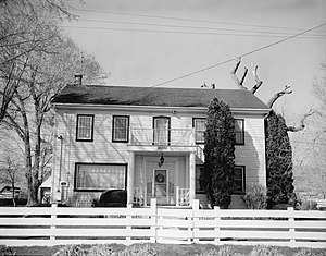
The Alamo Ranchhouse, near Steamboat, Nevada, is a historic "plantation style mansion" that was built in 1887. Also known as the Moffat Ranchhouse, it was listed on the National Register of Historic Places in 1979. The listing included one contributing building and one contributing structure.

Peleg Brown Ranch
United States historic place
Distance: Approx. 5439 meters
Latitude and longitude: 39.41194444,-119.74916667
The Peleg Brown Ranch, at 12945 Old Virginia Rd. in Reno, Nevada, dates from 1864. Also known as the Louis Damonte Ranch, it includes Bungalow/craftsman and Greek Revival architecture.
Mount Rose Station
Distance: Approx. 5093 meters
Latitude and longitude: 39.399659,-119.750834
Mount Rose Station is a proposed hotel and casino located at the intersection of Herz Boulevard and Mount Rose Highway next to The Summit in Reno, Nevada. The land is owned by Station Casinos and is located on 88 acres (36 ha) of land. The building design is similar to Aliante (formerly known as Aliante Station), Green Valley Ranch and Red Rock Resort.
Virginia City Highlands, Nevada
Unincorporated community in the state of Nevada, United States
Distance: Approx. 4344 meters
Latitude and longitude: 39.38083333,-119.64388889
Virginia City Highlands is an unincorporated community north of Virginia City, Nevada straddling the Storey County and Washoe County border. The community consists of widely dispersed residences. It can be accessed by Cartwright Road and Lousetown Road off Nevada State Route 341.

Damonte Ranch
Distance: Approx. 5541 meters
Latitude and longitude: 39.41244,-119.75016
The Damonte Ranch started in 1939 when Louis Damonte, an Italian immigrant farmed alfalfa and raised cattle. The original Damonte Ranch included about 620 acres (250 ha) known as the Peleg Brown Ranch, at 12945 Old Virginia Road in Reno, Nevada, back in 1864. Author Holly Walton-Buchanan, whose latest book, "Land of the Buckaroo: Historic Ranches of Western Nevada" includes a chapter in his book on the Brown-Damonte Ranch.
Weather in this IP's area
clear sky
16 Celsius
15 Celsius
13 Celsius
18 Celsius
1010 hPa
38 %
1010 hPa
816 hPa
10000 meters
3.13 m/s
8.49 m/s
4 degree
05:54:34
20:15:44