Country:
 USA
USARegion:
City:
Latitude and Longitude:
Time Zone:
Postal Code:
IP information under different IP Channel
ip-api
Country
Region
City
ASN
Time Zone
ISP
Blacklist
Proxy
Latitude
Longitude
Postal
Route
IPinfo
Country
Region
City
ASN
Time Zone
ISP
Blacklist
Proxy
Latitude
Longitude
Postal
Route
MaxMind
Country
Region
City
ASN
Time Zone
ISP
Blacklist
Proxy
Latitude
Longitude
Postal
Route
Luminati
Country
USRegion
nj
City
pleasantville
ASN
Time Zone
America/New_York
ISP
CL-1379-14537
Latitude
Longitude
Postal
db-ip
Country
Region
City
ASN
Time Zone
ISP
Blacklist
Proxy
Latitude
Longitude
Postal
Route
ipdata
Country
Region
City
ASN
Time Zone
ISP
Blacklist
Proxy
Latitude
Longitude
Postal
Route
Popular places and events near this IP address
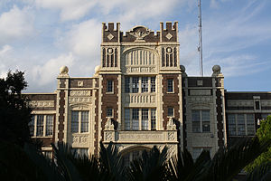
Baton Rouge Magnet High School
Public, magnet school in Baton Rouge, Louisiana, United States
Distance: Approx. 2834 meters
Latitude and longitude: 30.44531,-91.15967
Baton Rouge Magnet High School (BRMHS or Baton Rouge High) is a public magnet school in Baton Rouge, Louisiana, United States, founded in 1880. It is part of the East Baton Rouge Parish School System with a student body of approximately 1500 students. The current building was built in 1926, and, as Baton Rouge High School, was listed on the National Register of Historic Places in 1986.

Roman Catholic Diocese of Baton Rouge
Diocese of the Catholic Church
Distance: Approx. 1574 meters
Latitude and longitude: 30.45805556,-91.14027778
The Diocese of Baton Rouge (Latin Dioecesis Rubribaculensis; French Diocèse de Bâton-Rouge; Spanish: Diócesis de Baton Rouge), is a Latin Church ecclesiastical territory or diocese in the Florida Parishes region of the U.S. state of Louisiana. It is a suffragan in the ecclesiastical province of the Metropolitan Archdiocese of New Orleans. The current bishop is Michael Duca.
Independence Park Botanic Gardens
Distance: Approx. 2346 meters
Latitude and longitude: 30.4446,-91.1059
The Independence Park Botanic Gardens are botanical gardens located in Independence Park at 7950 Independence Boulevard, Baton Rouge, Louisiana. They are open during daylight hours without admission fee. The Gardens contain displays of blooming woody plants, ground covers, and wetland plants.

Battle of Baton Rouge (1779)
Distance: Approx. 456 meters
Latitude and longitude: 30.45,-91.1333
The Battle of Baton Rouge was a brief siege during the Anglo-Spanish War that was decided on September 21, 1779. Fort New Richmond (present-day Baton Rouge, Louisiana) was the second British outpost to fall to Spanish arms during Bernardo de Gálvez's march into West Florida.

Baton Rouge Community College
Public college in Baton Rouge, Louisiana, US
Distance: Approx. 560 meters
Latitude and longitude: 30.44888889,-91.13555556
Baton Rouge Community College is a public community college in Baton Rouge, Louisiana. Established on June 28, 1995, the college settled into a permanent location in 1998. The 60-acre (240,000 m2) campus consists of six main buildings: Governors Building, Louisiana Building, Cypress Building, Bienvenue Student Center, the Magnolia Library and Performing Arts Pavilion, and the Bonne Santé Wellness Center.
Catholic High School (Baton Rouge, Louisiana)
School in Baton Rouge, Louisiana, United States
Distance: Approx. 2603 meters
Latitude and longitude: 30.44083333,-91.15638889
Catholic High School is a private, Catholic college-preparatory day school run by the United States Province of the Brothers of the Sacred Heart in Baton Rouge, Louisiana. It was founded in 1894 as St. Vincent's Academy.
Garden District, Baton Rouge, Louisiana
United States historic place
Distance: Approx. 3509 meters
Latitude and longitude: 30.4399,-91.16585
The Garden District is a residential neighborhood located in Baton Rouge's Mid-City area where Park Boulevard intersects Government Street. The Garden District is an established historic area with many upscale homes and an active civic association [1]. The Garden District is actually a conglomerate of three historic districts as defined by the Louisiana National Register of Historic Places.
St. Joseph's Academy (Baton Rouge)
School in Baton Rouge, , Louisiana, United States
Distance: Approx. 2821 meters
Latitude and longitude: 30.43638889,-91.15694444
St. Joseph's Academy (SJA) is an all-girls Catholic school established in 1868 by the Sisters of St. Joseph of Medaille.
Baton Rouge General Medical Center – Mid-City Campus
Distance: Approx. 2214 meters
Latitude and longitude: 30.44938,-91.15309
Baton Rouge General - Mid City, also known as Mid City or The General, is a long term care, not-for-profit, community-owned hospital located in Baton Rouge, Louisiana. This hospital, established in the early 1900s, was the first official hospital to operate in the region. The hospital offers many services, including skilled nursing, wound care, and physical therapy.
Killing of Alton Sterling
2016 police killing of a black man in Baton Rouge, Louisiana, United States
Distance: Approx. 2514 meters
Latitude and longitude: 30.468,-91.13954
On July 5, 2016, Alton Sterling, a 37-year-old black man, was shot and killed by two Baton Rouge Police Department officers, Blane Salamoni and Howie Lake II, in Baton Rouge, Louisiana. The officers, who were attempting to control Sterling's arms, shot Sterling to death, which was preceded by Salamoni threatening Sterling with his gun before Sterling was restrained, yelling that he would "shoot [Sterling] in the fucking head" if he moved. Police alleged that Sterling had reached for the loaded handgun in his pants pocket.
East Baton Rouge Parish Library
Distance: Approx. 2318 meters
Latitude and longitude: 30.443034,-91.106471
East Baton Rouge Parish Library (EBRPL) is the public library system of East Baton Rouge Parish, Louisiana. It serves Baton Rouge and other cities in the parish.
Mid-City Tower
Skyscraper in Baton Rouge, Louisiana
Distance: Approx. 493 meters
Latitude and longitude: 30.4510094,-91.1321053
Mid-City Tower is a skyscraper in Mid-City Baton Rouge, Louisiana. Its exterior surface is wrapped entirely in concrete and glass. Completed in 1966, it has 14 floors and stands a height 53 meters (174 ft) tall.
Weather in this IP's area
clear sky
24 Celsius
25 Celsius
23 Celsius
25 Celsius
1016 hPa
93 %
1016 hPa
1014 hPa
10000 meters
06:20:30
20:01:17