Country:
 USA
USARegion:
City:
Latitude and Longitude:
Time Zone:
Postal Code:
IP information under different IP Channel
ip-api
Country
Region
City
ASN
Time Zone
ISP
Blacklist
Proxy
Latitude
Longitude
Postal
Route
IPinfo
Country
Region
City
ASN
Time Zone
ISP
Blacklist
Proxy
Latitude
Longitude
Postal
Route
MaxMind
Country
Region
City
ASN
Time Zone
ISP
Blacklist
Proxy
Latitude
Longitude
Postal
Route
Luminati
Country
USASN
Time Zone
America/Chicago
ISP
CL-1379-14537
Latitude
Longitude
Postal
db-ip
Country
Region
City
ASN
Time Zone
ISP
Blacklist
Proxy
Latitude
Longitude
Postal
Route
ipdata
Country
Region
City
ASN
Time Zone
ISP
Blacklist
Proxy
Latitude
Longitude
Postal
Route
Popular places and events near this IP address
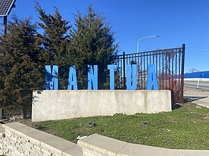
Mantua, Philadelphia
Neighborhood of Philadelphia
Distance: Approx. 534 meters
Latitude and longitude: 39.964,-75.194
Mantua is a neighborhood in the West Philadelphia section of Philadelphia, Pennsylvania. It is located north of Spring Garden Street, east of 40th Street, south of Mantua Avenue, and west of 31st Street. The neighborhood's northern and western reaches are predominantly working-class and African American, although its southern border with Powelton Village has seen recent gentrification and an influx of Drexel University and University of Pennsylvania student renters.

Penn Presbyterian Medical Center
Hospital in Pennsylvania, U.S.
Distance: Approx. 457 meters
Latitude and longitude: 39.95833333,-75.19916667
Penn Presbyterian Medical Center, sometimes called Presby, is a hospital located in the University City section of West Philadelphia. It was founded by Reverend Ephraim D. Saunders in 1871 and formally joined the University of Pennsylvania Health System in 1995. Penn Presbyterian is spread out on a campus bounded by Market Street, Powelton Avenue, 38th Street, and Sloan Street.

Black Bottom, Philadelphia
Historical neighborhood in Philadelphia, PA
Distance: Approx. 585 meters
Latitude and longitude: 39.9574,-75.1978
Black Bottom was a predominantly African American and poor neighborhood in West Philadelphia, Pennsylvania. It was mostly razed for urban renewal in the 1960s.

Belmont District, Pennsylvania
Former District in Pennsylvania, United States
Distance: Approx. 644 meters
Latitude and longitude: 39.96666667,-75.205
Belmont District was a district that existed briefly in Philadelphia County, Pennsylvania, United States. The district was created on April 14, 1853 from northern Blockley Township ceased to exist and on February 2, 1854 the district was incorporated into the City of Philadelphia following the passage of the Act of Consolidation, 1854. The name Belmont is still used as a neighborhood name for the area, although it no longer refers to any legal entity.

Saunders Park, Philadelphia
Neighborhood in Philadelphia, Pennsylvania, United States
Distance: Approx. 386 meters
Latitude and longitude: 39.959,-75.199
Saunders Park is a neighborhood in the West Philadelphia section of Philadelphia, Pennsylvania, United States. It is bounded by Powelton Avenue, 38th Street, Lancaster Avenue, and 40th Street. It is west of Powelton Village and north of Spruce Hill.

40th Street station (Market–Frankford Line)
Rapid transit station in Philadelphia
Distance: Approx. 627 meters
Latitude and longitude: 39.957,-75.202
40th Street station is an underground station on the SEPTA Market-Frankford Line, located the intersection of 40th Street and Market Street in Philadelphia, Pennsylvania, on the line between the Spruce Hill and Powelton Village neighborhoods in the University City District of West Philadelphia. The station serves a major shopping corridor of West Philadelphia on 40th Street, as well as the campus of the University of Pennsylvania, which lies three blocks south of the station. The station is served by SEPTA City Bus routes 30, 40 and LUCY. The station also serves as the inbound terminal for the SEPTA subway-surface trolley lines when services are diverted from the Market Street tunnels –– on Mondays from 12:00 a.m.

Drexel Dragons
Intercollegiate sports teams of Drexel University
Distance: Approx. 734 meters
Latitude and longitude: 39.96057,-75.20817
The Drexel Dragons are the athletic teams of Drexel University in Philadelphia, Pennsylvania. The school's athletic program includes eighteen NCAA Division I sports including nine men's and nine women's teams, with most sports teams competing in the Coastal Athletic Association (CAA). Drexel's athletic department was ranked first in gender equity by U.S. News.

Philadelphia Ronald McDonald House
Distance: Approx. 757 meters
Latitude and longitude: 39.955675,-75.201222
The Philadelphia Ronald McDonald House was the first of the Ronald McDonald House Charities and now stands at 39th and Chestnut Streets in West Philadelphia.
University City Science Center
Urban research park in Philadelphia, United States
Distance: Approx. 675 meters
Latitude and longitude: 39.956775,-75.196945
The University City Science Center (UCSC) is an urban research park in Philadelphia, Pennsylvania, United States. It was established as the first and largest urban research park in the United States. It was established in 1963, within the demolished Black Bottom neighborhood of Philadelphia, now known as University City.
Belmont Charter School
United States historic place
Distance: Approx. 644 meters
Latitude and longitude: 39.96666667,-75.205
The Belmont Charter School is a historic school building located in the Belmont neighborhood of Philadelphia, Pennsylvania, United States. It was added to the National Register of Historic Places in 1988.

Bell Telephone Exchange Building (Powelton Village, Philadelphia, Pennsylvania)
United States historic place
Distance: Approx. 630 meters
Latitude and longitude: 39.95777778,-75.20416667
Bell Telephone Exchange Building, also known as the Preston Telephone Exchange, is a historic telephone exchange located in the Powelton Village neighborhood of Philadelphia, Pennsylvania. It was built about 1900, by the Bell Telephone Company. It is a three-story, five-bay, brick building on a raised basement and once set within a set of rowhouses.
Haverford North
Neighborhood of Philadelphia in Pennsylvania, United States
Distance: Approx. 657 meters
Latitude and longitude: 39.9653,-75.2066
Haverford North is a neighborhood in the West Philadelphia section of Philadelphia, Pennsylvania, United States. It is located north of Haverford Avenue, east of 44th Street, south and west of Lancaster Avenue, and west of 40th Street. The neighborhood borders Mantua, Dunlap, and Powelton Village according to Google Maps.
Weather in this IP's area
few clouds
17 Celsius
17 Celsius
15 Celsius
19 Celsius
1021 hPa
87 %
1021 hPa
1017 hPa
10000 meters
20 %
05:55:57
20:18:24